
West Bromwich, commonly known as West Brom, is a market town in the borough of Sandwell, West Midlands, England. Historically part of Staffordshire, it is 7 miles northwest of Birmingham. West Bromwich is part of the area known as the Black Country, in terms of geography, culture and dialect. West Bromwich had a population of 103,112 in the 2021 Census.

Smethwick is an industrial town in Sandwell, West Midlands, England. It lies 4 miles (6 km) west of Birmingham city centre. Historically it was in Staffordshire and then Worcestershire before being placed into then West Midlands county.
Sandwell is a metropolitan borough of the West Midlands county in England. The borough is named after the Sandwell Priory, and spans a densely populated part of the West Midlands conurbation. Sandwell Metropolitan Borough Council defines the borough as the six amalgamated towns of Oldbury, Rowley Regis, Smethwick, Tipton, Wednesbury and West Bromwich. Rowley Regis includes the towns of Blackheath and Cradley Heath.

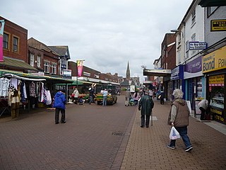
Oldbury is a market town in the Metropolitan Borough of Sandwell, West Midlands, England. It is the administrative centre of the borough. At the 2011 census, the town had a population of 13,606, while the 2017 population of the wider built-up area was estimated at 25,488. Sandwell Metropolitan Borough Council, which defines Oldbury Town as consisting of the wards of Bristnall, Langley, Oldbury, and Old Warley, gave the population as 50,641 in 2011.
Rowley Regis is a town and former municipal borough in Sandwell in the county of the West Midlands, England. It forms part of the area immediately west of Birmingham known as the Black Country and encompasses the three Sandwell council wards of Blackheath, Cradley Heath and Old Hill, and Rowley. At the 2011 census, the combined population of these wards was 50,257.

Sandwell Metropolitan Borough Council, or Sandwell Council, is the local authority of the Metropolitan Borough of Sandwell in the West Midlands, England. It is a metropolitan borough council and provides the majority of local government services in the borough. The council has been a member of the West Midlands Combined Authority since 2016.

Warley was a short-lived county borough and civil parish in the geographical county of Worcestershire, England, forming part of the West Midlands conurbation. It was formed in 1966 by the combination of the existing county borough of Smethwick with the municipal boroughs of Oldbury and Rowley Regis, by recommendation of the Local Government Commission for England. It was abolished just 8 years later in 1974 under the Local Government Act 1972, with its area passing to the Metropolitan Borough of Sandwell.

Brandhall is a suburb of Oldbury in the south of the Metropolitan Borough of Sandwell, West Midlands, bordering Birmingham and Halesowen. The development of the area commenced during the 1930s with the construction of several hundred private houses along the Hagley Road and Wolverhampton Road, as well as several side roads leading off the main dual carriageways. Oldbury Corporation founded a municipal farm in 1943. In 1949, the farm included a piggery, and fields growing wheat, potatoes, barley, hay, clover and oats. Oldbury Council placed a public notice for the demolition and removal of the farm buildings in February 1952. Most of Brandhall was developed in the 1950s and 1960s, when several thousand council houses, flats and bungalows were built by Oldbury Council on farmland to the south of Brand Hall. The Hall, which had become the clubhouse for Brandhall Golf Course, was demolished. Some of the first families moving on to the estate were relocating from Smethwick. Most of the high and medium-rise flats in Brandhall were demolished in the early 2000s and in their place housing associations built new low-rise homes.

Bearwood is the southern part of Smethwick, in the metropolitan borough of Sandwell, West Midlands, England. It lies north of the A456 Hagley Road. Bearwood Hill was the original name of the High Street from Smethwick Council House to Windmill Lane. The border at the Shireland Brook where Portland Road, Edgbaston becomes Shireland Road, Smethwick is signed "Bearwood" as of February 2014.

The Birmingham to Worcester via Kidderminster line is a railway line which runs from Birmingham Snow Hill to Worcester via Stourbridge and Kidderminster in the West Midlands, England. It is one of the Snow Hill Lines, with trains operated by West Midlands Trains and Chiltern Railways using a variety of rolling stock including Class 172 and Class 168 diesel units. It is a future aspiration of Network Rail to electrify the entire line, as well as the Chiltern Main Line to London Marylebone.

Sandwell College is the only College of Further Education in Sandwell, West Midlands, England. It predominantly serves Sandwell, West Birmingham and adjacent areas of Dudley, Walsall and Wolverhampton. Following seven years of growth in student numbers, some 6000 16–18-year-old students currently study in the college.
The BCN Main Line, or Birmingham Canal Navigations Main Line is the evolving route of the Birmingham Canal between Birmingham and Wolverhampton in England.
Spon Lane railway station was a railway station in England, built by the London and North Western Railway on their Stour Valley Line in 1852. It served the western part of Smethwick.
Cape Hill is an area of Smethwick, in the Metropolitan Borough of Sandwell, West Midlands, England, 2+3⁄4 miles (4.4 km) west of Birmingham City Centre. The area includes Waterloo Road near Shireland Collegiate Academy and the High Street near Victoria Park; it borders Birmingham at the A457 Dudley Road. Cape Hill is Smethwick's busiest shopping area.
Smethwick is a town in the Metropolitan Borough of Sandwell, in the West Midlands of England.
Warley College, originally called Warley College of Technology, was a college of further and higher education which served the vicinity of Oldbury in the West Midlands of England. It was formed in 1968 by the amalgamation of Oldbury College of Further Education and Chance Technical College in Smethwick and named in accordance with the recently created County Borough of Warley. It was located on the main Wolverhampton – Birmingham road.
Tony O'Connor was a Jamaican teacher. His 1967 appointment as a headteacher in Smethwick England—he was the first black person to hold such a post—caused a racist backlash.
