
A metro station or subway station is a train station for a rapid transit system, which as a whole is usually called a "metro" or "subway". A station provides a means for passengers to purchase tickets, board trains, and evacuate the system in the case of an emergency. In the United Kingdom, they are known as underground stations, most commonly used in reference to the London Underground.

The Stockholm Metro is a rapid transit system in Stockholm, Sweden. The first line opened in 1950 as the first metro line in the Nordic countries, and today the system has 100 stations in use, of which 47 are underground and 53 above ground. There are three coloured lines, as shown on the tube maps, which form seven numbered routes with different termini. Routes numbered 17, 18 and 19, 13 and 14 and 10 and 11 all go through the centre of the city, resulting in a very centralized system. All three lines and seven routes interchange at T-Centralen station. Apart from this, there are three other interchange between lines, at Fridhemsplan, Slussen and Gamla stan stations.

Södermalm, often shortened to just Söder, is the southern district of Stockholm City Centre.
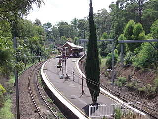
An island platform is a station layout arrangement where a single platform is positioned between two tracks within a railway station, tram stop or transitway interchange. Island platforms are popular on twin-track routes due to economic and land use reasons. They are also useful within larger stations where local and express services for the same direction of travel can be provided from opposite sides of the same platform thereby simplifying transfers between the two tracks. An alternative arrangement is to position side platforms on either side of the tracks. The historical use of island platforms depends greatly upon the location. In the United Kingdom the use of island platforms is relatively common when the railway line is in a cutting or raised on an embankment, as this makes it easier to provide access to the platform without walking across the tracks.
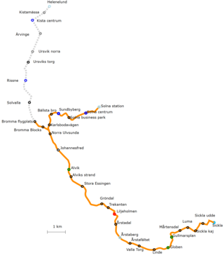
Tvärbanan is a light-rail line in Stockholm, Sweden. Its name literally translates to The transverse line, as it operates crosswise to the otherwise radial metro and commuter rail lines of Stockholm. It links together several transit lines through its connections with the southern, western and northern subway branches of the Stockholm Metro (Tunnelbana) as well as three branches of the Stockholm commuter rail (Pendeltåg). The possibility to travel between southern, western and northern greater Stockholm without having to enter the city centre significantly reduces the number of transit passengers, also reducing the number of trains having to pass through the Old Town bottleneck during peak hours. Near Liljeholmen the track is shared with freight traffic for a short section, this being the only place in Sweden where freight traffic and trams share the same track.

Nockebybanan is a tram line between Nockeby and Alvik in the western suburbs of Stockholm, Sweden. The 5.6 kilometers (3.5 mi) long line is part of the Storstockholms Lokaltrafik public transport network, and connects with the Stockholm metro and Tvärbanan tram at Alvik metro station. The Nockebybanan, also known as line 12, is operated by Arriva.
Stockholm commuter rail is the commuter rail system in Stockholm County, Sweden. The system is an important part of the public transport in Stockholm, and is controlled by Storstockholms Lokaltrafik. The tracks are state-owned and administered by the Swedish Transport Administration, while the operation of the Stockholm commuter rail services itself has been contracted to MTR Nordic since December 2016.

T-Centralen is a metro station that forms the heart of the Stockholm metro system, in the sense that it is the only station where all three of the system's lines meet. That, its central location, and its connections with other modes of transport make it the busiest station in the system. The station is located in the Norrmalm borough of Stockholm, between Sergels torg and the street of Vasagatan.
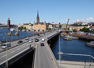
Centralbron is a major bridge in central Stockholm, Sweden, connecting the northern district Norrmalm to the southern Södermalm.

Rådmansgatan is an underground station on the Green line of the Stockholm metro. It lies below Sveavägen between its junctions with Rådmansgatan and Rehnsgatan in the district of Vasastaden and borough of Norrmalm in central Stockholm. The station has a single island platform, some 8 metres (26 ft) below street level, and is accessed via a pair of ticket halls at each end of the station. The ticket halls are accessed via staircases and lifts from the street above.

Norrström is one of the shortest rivers in Europe in central Stockholm. It connects Lake Mälaren with the Baltic Sea. It runs from Riddarfjärden, north of Gamla stan, to Stockholms ström. Two islands lie within it, Strömsborg and Helgeandsholmen. It is one of two natural waterways between Mälaren and the Baltic sea, the other being Söderström south of Gamla stan. Norrström is crossed by Centralbron and the adjacent pedestrian bridge, Vasabron, Riksbron north of Helgeandsholmen which continues into Riksgatan and Stallbron south of the island, Norrbro crossing Helgeandsholmen, and Strömbron.

Åkeshov is a station on the Green line of the Stockholm metro. It is located in the borough of Bromma in the west of the city of Stockholm. The station is at ground level, has two island platforms flanking three through tracks, and is one of the intermediate termini along the northern section of the Green line, with line 17 trains normally terminating. Access is by way of a pedestrian underpass that passes under both the metro line and the adjacent Bergslagsvägen street.

Abrahamsberg is a station on the Green line of the Stockholm metro. It is located on the border between the districts of Ulvsunda and Abrahamsberg, which are part of the borough of Bromma in the west of the city of Stockholm. The station is above ground and has a single island platform, with access from underpass carrying Abrahamsbergsvägen under the line.

Alvik metro station is a station on the Green line of the Stockholm metro, and on the Tvärbanan and Nockebybanan lines of Stockholm tramways. It is located on the border between the districts of Traneberg and Alvik, which are part of the borough of Bromma in the west of the city of Stockholm. The station is one of the intermediate termini along the northern section of the Green line, with line 18 trains normally terminating, and is also the terminus of the Nockebybanan.

Ängbyplan metro station, formerly known as Färjestadsvägen metro station, is a station on the Green line of the Stockholm metro. It is located in the district of Södra Ängby, which is part of the borough of Bromma in the west of the city of Stockholm. The station is above ground and has a single island platform, with access from the underpass taking Färjestadsvägen under the line. The distance to Slussen is 12.4 kilometres (7.7 mi).

Sankt Eriksplan is a station on the Green line of the Stockholm metro. It is entirely underground, and is located in the district of Vasastaden, which is in the borough of Norrmalm in central Stockholm. The station has a single island platform, some 8 metres (26 ft) below street level, and is accessed via a pair of ticket halls. One ticket hall is under Sankt Eriksplan itself, and the other under the intersection of Torsgatan and Sankt Eriksgatan. Both ticket halls are linked to the surface by entrance pavilions containing stairs and lifts. The distance to Slussen is 4.1 km (2.5 mi).

Hötorget, formerly known as Kungsgatan, is an underground station on the Green line of the Stockholm metro. It is situated near to the Hötorget square in the borough of Norrmalm in central Stockholm, and lies below Sveavägen between its junctions with Oxtorgsgatan and Apelbergsgatan. The station has three entrances, one at each end and one in the middle from Kungsgatan. The central entrance includes an underground square with several shops and stores. The distance to Slussen is 1.5 km (0.93 mi).

Medborgarplatsen, formerly known as Södra Bantorget, is a station on the Green line of the Stockholm metro. It is situated near to the Medborgarplatsen square in the district of Södermalm in central Stockholm, and lies below Götgatan between its junctions with Noe Arksgränden and Folkungagatan. The station has a single island platform, which is accessed by entrances at the junction of Götgatan with Folkungagatan, and in the Björns trädgård. The distance to Slussen is 0.6 km (0.37 mi).

The Red line, is one of the three Stockholm Metro lines. It has a total of 36 stations, of which four are cut and cover, 16 are tunneled, and 15 are on the surface. The line is a total of 41.238 kilometres (25.624 mi) long. It consists of four branches with terminals in Fruängen and Norsborg in the southwest and Mörby center and Ropsten in the northeast.

The Green Line is the oldest of the three Stockholm Metro lines. The 41.256-kilometre (25.635 mi) long line comprises a single double-tracked line north of the city centre, splitting into three branches south of the city centre. The first section of the line opened as a metro in 1950, making it the first and oldest metro line in the Nordic countries, although some parts of the line date back to the 1930s and were originally used by the Stockholm tramway.


