Ganda, Tibet

Last updated
Ganda
China Tibet location map.svg
Red pog.svg
Ganda
Location within Tibet
Coordinates: 31°30′N94°16′E / 31.500°N 94.267°E / 31.500; 94.267
Country China
Region Tibet
Population
  Total
       Major Nationalities Tibetan
       Regional dialect Tibetan language
    Time zone +8

    Coordinates: 31°30′N94°16′E / 31.500°N 94.267°E / 31.500; 94.267

    Geographic coordinate system Coordinate system

    A geographic coordinate system is a coordinate system that enables every location on Earth to be specified by a set of numbers, letters or symbols. The coordinates are often chosen such that one of the numbers represents a vertical position and two or three of the numbers represent a horizontal position; alternatively, a geographic position may be expressed in a combined three-dimensional Cartesian vector. A common choice of coordinates is latitude, longitude and elevation. To specify a location on a plane requires a map projection.

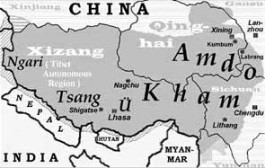
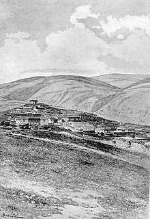
    Ganda is a town in Nagqu Prefecture in the Tibet Autonomous Region of China. It lies at an altitude of 12,750 ft (3,890 metres). [1] The Dzogchen Monastery is nearby.

    Tibet Autonomous Region Autonomous region

    The Tibet Autonomous Region (TAR) or Xizang Autonomous Region, called Tibet or Xizang for short, is a province-level autonomous region in southwest China. It was formally established in 1965 to replace the Tibet Area, an administrative division the People's Republic of China (PRC) took over from the Republic of China (ROC), about five years after the dismissal of the Kashag by the PRC following the 1959 Tibetan uprising, and about 13 years after Tibet's incorporation into the PRC in 1951.

    China Country in East Asia

    China, officially the People's Republic of China (PRC), is a country in East Asia and the world's most populous country, with a population of around 1.404 billion. Covering approximately 9,600,000 square kilometers (3,700,000 sq mi), it is the third- or fourth-largest country by total area. Governed by the Communist Party of China, the state exercises jurisdiction over 22 provinces, five autonomous regions, four direct-controlled municipalities, and the special administrative regions of Hong Kong and Macau.

    Dzogchen Monastery is one of the six great monasteries of the Nyingma tradition of Tibetan Buddhism. It is located in Kham within modern day Dêgê County, Garzê Tibetan Autonomous Prefecture, Sichuan, China.

    Related Research Articles

    Yarlung Tsangpo Grand Canyon canyon in Tibet, China

    The Yarlung Tsangpo Grand Canyon or Yarlung Zangbo Grand Canyon or simply the Tsangpo Canyon, Brahmaputra Canyon or Tsangpo Gorge, along the Yarlung Tsangpo River in Tibet Autonomous Region, China, is the deepest canyon in the world, and at 504.6 kilometres (313.5 mi) is slightly longer than the Grand Canyon in the United States, making it one of the world's largest. The Yarlung Tsangpo originates near Mount Kailash and runs east for about 1,700 kilometres (1,100 mi), draining a northern section of the Himalayas before it enters the gorge just downstream of Pei, Tibet near the settlement of Zhibe. The canyon has a length of about 240 kilometres (150 mi) as the gorge bends around Mount Namcha Barwa and cuts its way through the eastern Himalayan range. Its waters drop from about 2,900 metres (9,500 ft) near Pei to about 1,500 metres (4,900 ft) at the end of the Upper Gorge where the Po Tsangpo River enters. The river continues through the Lower Gorge to the Indian border at an elevation of 660 metres (2,170 ft). The river then enters Arunachal Pradesh and eventually becomes the Brahmaputra.

    Ü-Tsang Union of Ü and Tsang kingdoms in central Tibet, do not include Amdo (Qinghai) and Kham (Xikang) nor Ngari (western region, former Guge kingdom)

    Ü-Tsang or Tsang-Ü, is one of the four traditional provinces of Tibet, the other being Amdo in the North-East, the Kham in the East and the Ngari in the North-West. Geographically Ü-Tsang covered the south-central of the Tibetan cultural area, including the Brahmaputra River watershed. The western districts surrounding and extending past Mount Kailash are included in Ngari, and much of the vast Changtang plateau to the north. The Himalayas defined Ü-Tsang's southern border. The present Tibet Autonomous Region corresponds approximately to what was ancient Ü-Tsang and western Kham.

    Shigatse Prefecture-level city in Tibet Autonomous Region, Peoples Republic of China

    Shigatse, officially known as Xigazê, is a prefecture-level city of the Tibet Autonomous Region of China, with an area of 182,000 km2 (70,271 sq mi). It is located within the historical Tsang province of Tibet.

    Nyenchen Tanglha Mountains mountain range

    The Nyenchen Tanglha Mountains are a 700-kilometre (430 mi) long mountain range, and subrange of the Transhimalaya System, located in the Tibet region and the Tibet Autonomous Region of China.

    Qusum Town Place in Tibet Autonomous Region, China

    Qusum is a small Tibetan town and township in Qusum County in the Shannan Prefecture of Tibet, some 128km from Lhasa.

    Nyang River river of Tibet

    The Nyang River is a major river in south-west Tibet and the longest tributary of the Yarlung Tsangpo River.

    Dagring is a village in the Tibet Autonomous Region of China. It lies at an altitude of 4,433 metres. The village has a population of about 532.

    Dartang is a village in the Tibet Autonomous Region of China. It lies at an altitude of 4,144 metres. The village has a population of about 424.

    Doqemo is a village in the Tibet Autonomous Region of China. It lies at an altitude of 4,850 metres about halfway between Lhasa and Nagqu, to the east. The village has a population of about 238 people.

    Naixi is a village in the Tibet Autonomous Region of China.

    Gase Place in Tibet, China

    For the chemical compound, see Gallium(II) selenide. For the American football coach, see Adam Gase. For the American racing driver, see Joey Gase.

    Gongqên Place in Tibet, China

    Gongqen is a village in the Tibet Autonomous Region of China.

    Sato is a village in the Tibet Autonomous Region of China.

    Sêndo is a village in the Tibet Autonomous Region of China.

    Têmo is a village in the Tibet Autonomous Region of China.

    Kaika is a village in the Tibet Autonomous Region of China.

    Mamta is a village in the Tibet Autonomous Region of China.

    Xognga Place in Tibet, China

    Xognga is a village in the Tibet Autonomous Region of China.

    Gaocheng, Sichuan Town in Sichuan, China

    Litang Town is the administrative centre of Litang County in the southwest of the Garzê Tibetan Autonomous Prefecture in Sichuan Province of China.

    References

    1. McCue, Gary (1 October 2010). Trekking Tibet: A Traveler's Guide. The Mountaineers Books. p. 309. ISBN   978-1-59485-266-4 . Retrieved 13 March 2011.