
Tibet, or Greater Tibet, is a region in the western part of East Asia, covering much of the Tibetan Plateau and spanning about 2,500,000 km2 (970,000 sq mi). It is the homeland of the Tibetan people. Also resident on the plateau are some other ethnic groups such as the Monpa, Tamang, Qiang, Sherpa and Lhoba peoples and, since the 20th century, considerable numbers of Han Chinese and Hui settlers. Since the annexation of Tibet by the People's Republic of China in 1951, the entire plateau has been under the administration of the People's Republic of China. Tibet is divided administratively into the Tibet Autonomous Region, and parts of the Qinghai, Gansu, Yunnan and Sichuan provinces. Tibet is also constitutionally claimed by the Republic of China as the Tibet Area since 1912. Tibet is the highest region on Earth, with an average elevation of 4,380 m (14,000 ft). Located in the Himalayas, the highest elevation in Tibet is Mount Everest, Earth's highest mountain, rising 8,848 m (29,000 ft) above sea level.

The Tibet Autonomous Region, officially the Xizang Autonomous Region, often shortened to Tibet or Xizang, is an autonomous region of China and is part of Southwestern China.

The Potala Palace is a dzong fortress in Lhasa, capital of the Tibet Autonomous Region in China. It was the winter palace of the Dalai Lamas from 1649 to 1959, has been a museum since then, and a World Heritage Site since 1994.

The music of Tibet reflects the cultural heritage of the trans-Himalayan region centered in Tibet, but also known wherever ethnic Tibetan groups are found in Nepal, Bhutan, India and further abroad. The religious music of Tibet reflects the profound influence of Tibetan Buddhism on the culture.

The 13th Dalai Lama, Thubten Gyatso was the 13th Dalai Lama of Tibet, enthroned during a turbulent modern era. He presided during the Collapse of the Qing Dynasty, and is referred to as "the Great Thirteenth", responsible for redeclaring Tibet's national independence, and for his national reform and modernization initiatives.
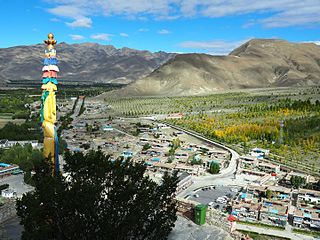
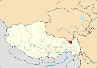
Shannan, also known as Lhoka, is a prefecture-level city in the southeastern Tibet Autonomous Region, China. Shannan includes Gonggar County within its jurisdiction with Gongkar Chö Monastery, Gonggar Dzong, and Gonggar Airport all located near Gonggar town.

Shipki La is a mountain pass and border post with a dozen buildings of significant size on the India-China border. The river Sutlej, which is called Langqên Zangbo in Tibet, enters India near this pass. A spur road on the Indian side rises to an altitude of 4,720 metres (15,490 ft) four km southwest of Shipki La.
Riwoche is a county under the administration of the prefecture-level city of Chamdo in the Tibet Autonomous Region, China. The county lies in eastern Tibet and borders Qinghai province to the north.
Dzongka or Zongga is a town and the administrative headquarters of Gyirong County in the southwestern Tibet region of China bordering Nepal. Being the administrative headquarters, it is also sometimes referred to as "Gyirong Dzong" or "Gyirong Town", but it is different from the original Kyirong Town in the southern part of the county.
Drakna, Drakne, or Chagnê is a township in Gyirong County, Tibet Autonomous Region of China.
Chamco is a village and township (村) in Tingri County, Tibet Autonomous Region of China.
Gyamco Township is a township of Tingri, Tibet Autonomous Region. Its downtown area, Guore village, also referred as Gyaco in English, is a village in the Tibet Autonomous Region of China.

Yatung or Yadong, also known as Shasima , is the principal town in the Chumbi Valley or Yadong County in the Tibet Autonomous Region of China. It is also its administrative headquarters.
Namling or Namlingxoi is a town and seat of Namling County in the Tibet Autonomous Region of China, about 72 kilometres (45 mi) by road northeast of Shigatse, north of Dobjoi.

Bhutan-China relations refer to the international relationship between the Kingdom of Bhutan and the People's Republic of China. As of present, Bhutan and China do not share an official diplomatic relationship with one another.

Tibet was a de facto independent state in East Asia that lasted from the collapse of the Qing dynasty in 1912 until its annexation by the People's Republic of China in 1951.
Lunana Gewog is a gewog of Gasa District, Bhutan. The village Lunana is the administrative center of Lunana Gewog.

The Yarlung dynasty, or Pre-Imperial Tibet, was a proto-historical dynasty in Tibet before the rise of the historical Tibetan Empire in the 7th century.

Demchok , previously called New Demchok, and called Parigas by the Chinese, is a village and military encampment in the Indian-administered Demchok sector, that is disputed between India and China. It is administered as part of the Nyoma tehsil in the Leh district of Ladakh by India, and claimed by China as part of the Tibet Autonomous Region.
The Demchok sector is a disputed area named after the villages of Demchok in Ladakh and Demchok in Tibet, situated near the confluence of the Charding Nullah and Indus River. It is a part of the greater Sino-Indian border dispute between China and India. Both China and India claim the disputed region, with a Line of Actual Control between the two nations situated along the Charding Nullah.

