Gara River Hydro-Electric Scheme

Last updated

Gara River Hydro-Electric Scheme
Australia New South Wales relief location map.png
Red pog.svg
Location of Gara River Hydro-Electric Scheme in New South Wales
Location10km southeast of Armidale, Castle Doyle, Armidale Regional Council, New South Wales, Australia
Coordinates 30°35′59″S151°48′29″E / 30.5996°S 151.8081°E / -30.5996; 151.8081 Coordinates: 30°35′59″S151°48′29″E / 30.5996°S 151.8081°E / -30.5996; 151.8081
Built18931895
ArchitectRichard Threlfall
Owner Office of Environment and Heritage
Official nameGara River Hydro-Electric Scheme
Typestate heritage (archaeological-terrestrial)
Designated2 April 1999
Reference no.986
TypeElectricity Generator/Power Station - hydro-electric
CategoryUtilities - Electricity
BuildersCrompton Power Company

Gara River Hydro-Electric Scheme is a heritage-listed former hydroelectric power station located at Castle Doyle, Armidale Regional Council, New South Wales, Australia. It was designed by Richard Threlfall and built from 1893 to 1895 by Crompton Power Company. The property is owned by the State Government's Office of Environment and Heritage. It was added to the New South Wales State Heritage Register on 2 April 1999. [1]

Contents

History

The Gara River scheme was the first substantial hydro-electric scheme to reach fruition in Australia. It began to generate power in March 1895 to light the town of Hillgrove, near Armidale in the New South Wales Central Tablelands. The scheme was instigated by the Australasian Rights Purchase Association, when they placed a petition for a bill before the Parliament of New South Wales, requesting the water rights to exploit the Gara River for the purposes of power generation. The bill was passed and on March 10, 1893, the Hillgrove and Armidale Water-Power Electrical Company (Ltd) Act, was passed. [2] [1]

Richard Threlfall, Professor of Physics at the University of Sydney, was brought in as the consultant on electrical engineering. He was regarded at the time as Australia's leading expert on electricity and is now thought to have been one of the first modern pure physicists in the world. He was involved in all phases of the design and construction and became mortgagee of the company. [3] [1]

The dam for the scheme was constructed at Blue Hole, a large natural pool of water off the Gara River. The generator site was situated at the foot of the Gara Falls. The site was only disadvantaged by its distance from the power consumers in the next gorge and the township. The system used DC (direct current) generators and briefly became one of the most important DC generation schemes in the world. [1]

Although the scheme was hailed as a technical triumph, it was plagued by financial trouble throughout the 1890s. This may have coincided with the economic decline that hailed the end of the goldrushes in the area. In 1896 the site was taken over by the Sandon County Electrical Light and Power Company and in 1899, the scheme was substantially rebuilt and reactivated with modifications to the flumes and machinery. The population of the area however, was dwindling due to reduced mineral production and the Sandon Company sold the plant to the International Railway Corporation of England. [4] By 1905 it was being leased or operated by a Mr Pinto who sold the electricity to local users. [1]

The last mention of the Gara River Hydro-Electric Scheme as a functioning enterprise was in 1907. The history of the site between 1907 and the later part of the twentieth century is unclear. The site now rests within the borders of the Oxley Wild Rivers National Park, under the management of the NSW National Parks and Wildlife Service. [1]

Description

The two ends of the rubble and earth dam at Blue Hole survive although it is not possible to determine which particular parts of the dam were built during the first or second phases of construction. Approximately 100m below the dam is a low concrete weir which spans the Gara River at one of its narrowest points. This was to divert water from the river into the flume at a certain rate to ensure constant supply. The weir remains intact and does not show any evidence of repair or alteration since its construction. [5] [1]

From the eastern end of the weir, a line of V sectioned concrete fluming extends southwards for 500m. After passing through a cutting the flume splits, with one half running on wooden trestles and the other following the fall of the land. The former is the original route of the flume. None of the timber fluming or framing of the trestles survives intact although many lie around the surface of the site. Stone footing supply the best evidence of the route. The second flume is represented by a narrow level surface about one metre across. [1]

At the end of the flume runs, a steep, poorly stabilized slope leads down to the powerstation below. The remains of the power station and sections of the power generating machinery are in various stages of decay. [6] [1]

Condition

The archaeological potential of the site was reported as being high as of 11 August 1997. [1]

Heritage listing

The Gara River hydro-electric scheme is of state and national significance because it was the first to light a township in Australia and the first to offer its power for commercial sale. As designed by Richard Threlfall, Professor of Physics at the University of Sydney, it incorporated technological innovations which made it one of the most advanced schemes in the world. [1]

It provides direct physical evidence of the changing economic fortunes of Hillgrove in the face of the 1890s depression, the drop in antimony prices and the drought. For modern Australian society, it provides a time depth for the environmental debates of hydro versus environment. [7] [1]

Gara River Hydro-Electric Scheme was listed on the New South Wales State Heritage Register on 2 April 1999 having satisfied the following criteria. [1]

The place is important in demonstrating the course, or pattern, of cultural or natural history in New South Wales.

The Gara River Hydro-electric scheme provides direct evidence for the early use of electricity in Australia. It was the first scheme in Australia to provide light to a town and the first to make its output commercially available for industry. It represents the only successful venture of the Australasian Purchase Rights Association. It has an association with the NSW parliamentarian, Frank Cotton, who acted as manager for the revived Gara River scheme. It also has an association with Richard Threlfall, Professor of physics at the University of Sydney. [8] [1]

The place has strong or special association with a particular community or cultural group in New South Wales for social, cultural or spiritual reasons.

The Gara River Hydro-electric scheme, represents a part of the historical heritage of the New England district and still has relevance to the local community. It has long been used as a recreational area by the residents of Armidale. It also provides a time depth for the wider community, for the development of hydro-electricity and its conflict with the environment. This has become increasingly relevant since the Franklin River dam protests in 1983–4. [9] [1]

The place has potential to yield information that will contribute to an understanding of the cultural or natural history of New South Wales.

The Gara River Hydro-electric scheme represents several technological firsts, such as the first use of tandem hydro-electric power generating machines in Australia. Technologically it was also a world leader in the use of high voltage power transmission. The overall design, the use of direct current generators and the changes in fluming to improve water flow also have high technological significance. The scheme represents the only known large scale design work carried out by Professor Threlfall, a significant early physicist. [1]

The Gara River Hydro-electric scheme also has research and educational potential. There is enough easily accessible material, visible on the surface to provide for straightforward interpretation. As the records of early hydro-electric development are patchy, the archaeological remains are an invaluable source of information about this technology. A study of the place also reveals how the end of the antimony boom and the collapse of the Australian economy in the 1890s, influenced the local economy of Hillgrove. [10] [1]

See also

Related Research Articles

Oxley Wild Rivers National Park Protected area in New South Wales, Australia

The Oxley Wild Rivers National Park is a protected national park that is located in the Northern Tablelands region of New South Wales, Australia in the Port Macquarie-Hastings City Council and Walcha Shire councils. The 145,223-hectare (358,850-acre) park is situated 445 kilometres (277 mi) north of Sydney and is named in memory of the Australian explorer John Oxley, who passed through the area in 1818 and is one of the largest national parks in New South Wales.

Snowy Mountains Scheme Dam in Kosciuszko National Park, New South Wales

The Snowy Mountains Scheme or Snowy scheme is a hydroelectricity and irrigation complex in south-east Australia. The Scheme consists of sixteen major dams; nine power stations; two pumping stations; and 225 kilometres (140 mi) of tunnels, pipelines and aqueducts that were constructed between 1949 and 1974. The Scheme was completed under the supervision of Chief Engineer, Sir William Hudson. It is the largest engineering project undertaken in Australia.

Armidale City in New South Wales, Australia

Armidale is a city in the Northern Tablelands, New South Wales, Australia. Armidale had a population of 24,504 as at June 2018. It is the administrative centre for the Northern Tablelands region. It is approximately halfway between Sydney and Brisbane at the junction of the New England Highway and Waterfall Way. The traditional owners of the land of Armidale are the Anaiwan Peoples.

Hydro Tasmania

Hydro Tasmania, known for most of its history as the Hydro-Electric Commission (HEC) or The Hydro, is the trading name of the Hydro-Electric Corporation, a Tasmanian Government business enterprise which is the predominant electricity generator in the state of Tasmania, Australia. The Hydro was originally oriented towards hydro-electricity, due to Tasmania's dramatic topography and relatively high rainfall in the central and western parts of the state. Today Hydro Tasmania operates thirty hydro-electric and one gas power station, and is a joint owner in three wind farms.

Waddamana Power Stations Hydro-electric power plant in Tasmania

Waddamana Hydro-Electric power station was the first hydro-electric power plant ever operated by the Tasmanian Hydro-Electric Department, opened in 1916.

Snowy Hydro Limited is an electricity generation and retailing company in Australia that owns, manages, and maintains the Snowy Mountains Hydro-electric Scheme which consists of nine hydro-electric power stations and sixteen large dams connected by 145 kilometres (90 mi) of tunnels and 80 kilometres (50 mi) of aqueducts located mainly in the Kosciuszko National Park. Snowy Hydro also owns and operates two gas-fired power stations in Victoria and one in New South Wales, three diesel power stations in South Australia, and owns two electricity retailing businesses.

Waterfall Way

The Waterfall Way is a road in New South Wales, Australia. It runs east-west from the Pacific Highway to the New England Highway at Armidale. The route passes through some of New South Wales' most scenic countryside and has become well known as its best and Australia's third most beautiful tourist drive. Seven national parks, of which three are listed as World Heritage Areas by UNESCO and form part of the Gondwana Rainforests of Australia, are located on or close to the route. Dorrigo National Park encompasses the waterfalls that give the route its name. It also provides one of the few road links between coastal and inland New South Wales, and is therefore more heavily trafficked than its condition might otherwise suggest.

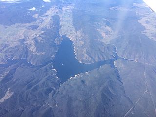
Lostock Dam is a minor rockfill and clay core embankment dam with a concrete lined, flip bucket spillway across the Paterson River upstream of the village of East Gresford in the Hunter region of New South Wales, Australia. The dam's purpose includes flood mitigation, irrigation, water supply and conservation. Mini hydro-power facilities were retrofitted in 2010. The impounded reservoir is also called Lostock Dam.

Burrinjuck Dam Dam in South West Slopes, New South Wales

Burrinjuck Dam is a heritage-listed major gated concrete-walled gravity hydro-electric dam at Burrinjuck, Yass Valley Shire, New South Wales, Australia. It has three spillways across the Murrumbidgee River located in the South West Slopes region of New South Wales, Australia. The dam's purpose includes flood mitigation, hydro-power, irrigation, water supply and conservation. The impounded reservoir is called Lake Burrinjuck. It was designed by Lawrence Augustus Burton Wade and built from 1907 to 1927 by Lane & Peters, Sydney. It is also known as Barren Jack Dam and Barrenjack. The property was owned by Department of Planning and Infrastructure. It was added to the New South Wales State Heritage Register on 2 April 1999.

Guthega, New South Wales Town in New South Wales, Australia

Guthega is a ski village and the site for a hydro electric dam located in the Kosciuszko National Park, on the upper reaches of the Snowy River, on the western face of Mount Blue Cow, Snowy Mountains of New South Wales, Australia.

The Shoalhaven Scheme is a dual-purpose water supply and Pumped-storage Hydroelectricity scheme located on the South Coast region of New South Wales, Australia.

Guthega Power Station Dam in Snowy Mountains, New South Wales

Guthega Power Station is located in the Snowy Mountains region of New South Wales, Australia. The power station's purpose is for the generation of electricity. It is the first to be completed and smallest of the initial seven hydroelectric power stations that comprise the Snowy Mountains Scheme, a vast hydroelectricity and irrigation complex constructed in south-east Australia between 1949 and 1974 and now run by Snowy Hydro.

Tumut Hydroelectric Power Station Power stations in New South Wales, Australia

Tumut Hydroelectric Power Station is a series of three of the original four, now five hydroelectric power stations on the Tumut River in New South Wales, Australia, that are part of the Snowy Mountains Scheme.

Northern Tablelands Region in New South Wales, Australia

The Northern Tablelands, also known as the New England Tableland, is a plateau and a region of the Great Dividing Range in northern New South Wales, Australia. It includes the New England Range, the narrow highlands area of the New England region, stretching from the Moonbi Range in the south to the Queensland border in the north. The region corresponds generally to the Bureau of Meteorology forecast area for the Northern Tablelands which in this case includes Inverell although it is significantly lower in elevation.

Chichester Dam Dam in Dungog, New South Wales

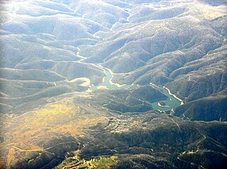
Chichester Dam is a minor concrete gravity dam across the Chichester and Wangat rivers, upstream of Dungog, in the Hunter Region of New South Wales, Australia. The dam's main purpose is water supply for the Lower Hunter region. A mini hydro-electric power station operates at times of peak flow and is connected to the national grid. The impounded reservoir is Lake Chichester.

Tooma River River in New South Wales, Australia

Tooma River, a perennial stream that has had some of its flow diverted as a result of the Snowy Mountains Scheme, is part of the Murray catchment within the Murray–Darling basin and is located in the Australian Alpine region of New South Wales, Australia.

Hillgrove, New South Wales

Hillgrove is a Northern Tablelands village with population of about 95. The village is located approximately 30 km east of Armidale and is 5 kilometres south of the Waterfall Way. Hillgrove is part of the Armidale Regional Council local government area and is in Sandon County. This historic goldmining town is situated at elevation of 1,000 metres on a granite plateau above Bakers Creek and near the Oxley Wild Rivers National Park.

Hydroelectricity in the United Kingdom

As of 2018, hydroelectric power stations in the United Kingdom accounted for 1.87 GW of installed electrical generating capacity, being 2.2% of the UK's total generating capacity and 4.2% of UK's renewable energy generating capacity. This includes four conventional hydroelectric power stations and run-of-river schemes for which annual electricity production is approximately 5,000 GWh, being about 1.3% of the UK's total electricity production. There are also pumped-storage hydroelectric power stations providing a further 2.8 GW of installed electrical generating capacity, and contributing up to 4,075 GWh of peak demand electricity annually.

Castle Doyle is a locality in the Armidale Regional Council region of New South Wales, Australia. It is bounded by Commissioners Waters to the north and the Gara River to the east. It had a population of 164 as of the 2016 census.

Mullumbimby Hydro-electric Power Station Complex Historic site in New South Wales, Australia

Mullumbimby Hydro-electric Power Station Complex is a heritage-listed former hydroelectric power station at Wilsons Creek Road, Mullumbimby, Byron Shire, New South Wales, Australia. It was designed by William Corin and built from 1924 to 1926. It is also known as Lavertys Gap Power Station and Mullumbimby Power Station and Substation. The property is owned by the Byron Shire Council and Essential Energy. It was added to the New South Wales State Heritage Register on 27 June 2014.

References

  1. 1 2 3 4 5 6 7 8 9 10 11 12 13 14 15 16 17 "Gara River Hydro-Electric Scheme". New South Wales State Heritage Register . Office of Environment & Heritage. H00986. Retrieved 28 May 2018.
  2. Gojack et.al. 1988: 15
  3. Gojak et.al 1988: 15
  4. Gojak et.al. 1988: 19
  5. Gojack et.al 1988: 22
  6. Gojak et.al. 1988: 24
  7. Gojak et.al. 1988: 32
  8. Gojak et.al. 1988: 27-8&32-3
  9. Gojak et.al. 1988: 26&32
  10. Gojak et.al. 198827&33

Bibliography

Attribution

CC BY icon-80x15.png This Wikipedia article was originally based on Gara River Hydro-Electric Scheme , entry number 00986 in the New South Wales State Heritage Register published by the State of New South Wales and Office of Environment and Heritage 2018 under CC-BY 4.0 licence , accessed on 28 May 2018.