Garibaldi, Rio Grande do Sul

Last updated
Garibaldi
Municipality of Garibaldi
Centro hs.jpg
Garibaldi rs.jpg
Est. Ferroviaria de Garibaldi 13.01.2016.jpg
Entree de Garibaldi.JPG
Maria fumaca e natureza em Garibaldi - RS.JPG
Garibaldi300000.jpg
Est. Ferroviaria de Garibaldi 13.01.2016 5.jpg
Bandeira Garibaldi.gif
Brasao Garibaldi.gif
RioGrandedoSul Municip Garibaldi.svg
Brazil State RioGrandedoSul.svg
Coordinates: 29°17′20″S51°33′51″W / 29.28889°S 51.56417°W / -29.28889; -51.56417
Country Flag of Brazil.svg  Brazil
Region South
State Bandeira do Rio Grande do Sul.svg  Rio Grande do Sul
FoundedOctober 31, 1900
Government
  MayorCirano Cisilotto (PT) (2009-2012)
Area
  Total169.7 km2 (65.5 sq mi)
Elevation
613 m (2,011 ft)
Population
 (2020 [1] )
  Total35,440
Time zone UTC−3 (BRT)
HDI (2010)0.786 – high [2]
Website www.garibaldi.rs.gov.br

Garibaldi is a municipality in Rio Grande do Sul, southern Brazil. It has a population of 35,440 people, most of them of Italian descent [ citation needed ]. The city is famous for its wine and sparkling wine productions. The name Garibaldi is a homage to the Italian revolutionary Giuseppe Garibaldi and his Brazilian wife, Anita Garibaldi. It was settled by Italian immigrants, predominantly Venetians and Prussians in the late 19th century. [3]

Contents

History

The beginning

In 1870, chairman Dr. João Sertório created the colony of Conde d'Eu, in honor of the emperor's son-in-law, who married Princess Isabel. The two colonies had 32 square leagues of land. The region did not attract much interest, because its lands were rugged. An infrastructure investment was necessary to attract settlers, but as the government was not willing to make such an investment, the settlement sought other resources to make the land habitable and arable. The government decided to populate the region with European immigrants.

The settlement of Colony Conde d'Eu occurred at the end of the imperial stage. The first immigrants arrived on July 9, 1870, and they were all Prussians (Germans). At the same period, some Amerindian families, or "Bugres" as they were commonly identified, also settled there. During this period of settlement, the Germans lived on subsistence agriculture. At that time, the only existing road, which was in terrible condition, connected Conde D'Eu to Montenegro through Maratá. Using this road, some Swiss, Italian, French, Austrian and Polish immigrants arrived in 1874 and 1875.

Italian settlement

The largest number of immigrants came from Italy. The Colony Conde d'Eu was the first nucleus of colonization in mountain region of Rio Grande do Sul. The population of the colony, which in 1875 was of only 720 inhabitants, reached 870 persons in 1876. From 1890, when the colony was established, the houses and buildings that today form the Historical Center were built. On October 31, 1900, the government raised the Colony Conde d'Eu to a municipality, which then became Garibaldi.

Today, almost all the inhabitants of the city are descended from immigrants [ citation needed ].

Wine and sparkling wine productions

When the Italian immigrants came to Garibaldi they brought vineyards. Over time, wine production became very important to the regional economy. More recently, sparkling wine also started to be produced there, and the town is now the main producer of the beverage in Brazil.

Social and Economic Information

Infra Structure

Number of Elementary Schools: 25; High School: Three; Number of Schools of Higher Education: One; Private Schools: Two; Number of schools in Child Education: Four; Sewerage system (% of households served): 90%; Supply of drinking water (% of households served): 98% ; Number of squares and parks of urban areas: 14 ;

Economy (2007)

Companies located in the city: Industry: 319, Commerce: 788; Services: 1152 and 220 professionals. Economic base: Industry

Geography

Altitude: 613m; Climate: Subtropical; Temperature: In summer reaches 33 °C (91 °F) in winter -3.5 °C (38.3 °F) ; No. of Districts: 27; Area of the city: 169.69 km2; Access: RSC 470 / RSC 453 - Route of the Sun / BR 116 / RSC 240 / RSC 446. [4]

Tourism

Route of the Sparkling Wines

Under coordination of the Secretary of Tourism, Sebrae and Atuaserra, seven wineries and beverage companies of Garibaldi are integrated to implement a roadmap that sought to explore the main product of Garibaldi: the champagne. In this route the tourist has the opportunity to taste the most famous and delicious Brazilian sparkling wines, in addition to knowing the location and process of preparing the drink in a city that is characterized by the charm of its historic architecture, beauty landscape and the friendliness of its people.

Road of Flavour

To offer to the visitors the pleasure of enjoying the passion for the things of earth, five communities developed the road of flavour project, a tour of vineyards and valleys through caves and churches, tasting the colonial products without forgetting the good wines of the land. All of that produced with raw materials grown on each property. [5]

Climate

Climate data for Garibaldi  (1961 - 1990)  
MonthJanFebMarAprMayJunJulAugSepOctNovDecYear
Average high °C (°F)27.0
(80.6)
26.1
(79.0)
26.1
(79.0)
23.0
(73.4)
20.0
(68.0)
17.7
(63.9)
18.0
(64.4)
18.9
(66.0)
20.4
(68.7)
22.7
(72.9)
25.1
(77.2)
27.2
(81.0)
22.7
(72.8)
Daily mean °C (°F)22.4
(72.3)
22.0
(71.6)
21.4
(70.5)
18.3
(64.9)
15.6
(60.1)
13.5
(56.3)
13.6
(56.5)
14.3
(57.7)
15.8
(60.4)
17.7
(63.9)
19.9
(67.8)
21.9
(71.4)
18.0
(64.4)
Average low °C (°F)17.7
(63.9)
17.9
(64.2)
16.6
(61.9)
13.6
(56.5)
11.2
(52.2)
9.2
(48.6)
9.1
(48.4)
9.7
(49.5)
11.1
(52.0)
12.6
(54.7)
14.6
(58.3)
16.5
(61.7)
13.3
(56.0)
Average precipitation mm (inches)136.4
(5.37)
129.9
(5.11)
177.4
(6.98)
127.9
(5.04)
138.2
(5.44)
152.8
(6.02)
135.9
(5.35)
121.8
(4.80)
155.8
(6.13)
147.5
(5.81)
99.9
(3.93)
122.7
(4.83)
1,646.2
(64.81)
Source: Clic RBS (in Portuguese) [6]

International relations

Twin towns - Sister cities

Garibaldi is twinned with:

Notable people

Related Research Articles

<span class="mw-page-title-main">Rio Grande do Sul</span> State of Brazil

Rio Grande do Sul is a state in the southern region of Brazil. It is the fifth-most-populous state and the ninth largest by area. Located in the southernmost part of the country, Rio Grande do Sul is bordered clockwise by Santa Catarina to the north and northeast, the Atlantic Ocean to the east, the Uruguayan departments of Rocha, Treinta y Tres, Cerro Largo, Rivera and Artigas to the south and southwest, and the Argentine provinces of Corrientes and Misiones to the west and northwest. The capital and largest city is Porto Alegre. The state has the highest life expectancy in Brazil, and the crime rate is relatively low compared to the Brazilian national average. Despite the high standard of living, unemployment is still high in the state, as of 2017. The state has 5.4% of the Brazilian population and it is responsible for 6.6% of the Brazilian GDP.

<span class="mw-page-title-main">Santa Catarina (state)</span> State of Brazil

Santa Catarina is a state in the South Region of Brazil. Of Brazil's 26 states, it is the seventh-smallest state in total area and the 11th most populous. Additionally, it is the ninth-largest settlement, with 295 municipalities. The state, with 3.4% of the Brazilian population, generates 3.8% of the national GDP.

<span class="mw-page-title-main">Caxias do Sul</span> Municipality in South, Brazil

Caxias do Sul is a city in Rio Grande do Sul, Southern Brazil, situated in the state's mountainous Serra Gaúcha region. It was established by Italian immigrants on June 20, 1890. Today it is the second largest city in the state of Rio Grande do Sul. In 2020, the population of Caxias do Sul was estimated at 517,451 people, many of whom are of Italian and German descent. The demonym of the citizens of Caxias do Sul is Caxiense.

<span class="mw-page-title-main">German Brazilians</span> Brazilian person of ethnic German ancestry or origin

German Brazilians refers to Brazilians of full or partial German ancestry. German Brazilians live mostly in the country's South Region, with a smaller but still significant percentage living in Southeast Region.

Talian, or Brazilian Venetian, is a dialect of the Venetian language, spoken primarily in the Serra Gaúcha region in the northeast of the state of Rio Grande do Sul in Brazil. It is also spoken in other parts of Rio Grande do Sul, as well as in parts of Espirito Santo and of Santa Catarina.

<span class="mw-page-title-main">Brazil socio-geographic division</span>

The Brazil socio-geographic division is a slightly different division than the Brazilian Division by Regions. It separates the country into three different and distinctive regions:

<span class="mw-page-title-main">Bento Gonçalves, Rio Grande do Sul</span> Municipality in South, Brazil

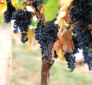
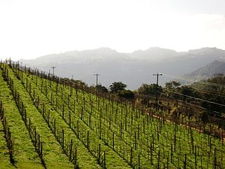
Bento Gonçalves is a municipality located in the state of Rio Grande do Sul, Brazil. Created in 1875, it is one of the centers of the Italian immigration in Brazil. It is also known as the 'wine capital of Brazil' due to its vineyards and wine production. In 2020, its estimated population was 121,803 inhabitants.

<span class="mw-page-title-main">Serra Gaúcha</span> Mountain range and cultural region in Rio Grande do Sul, Brazil

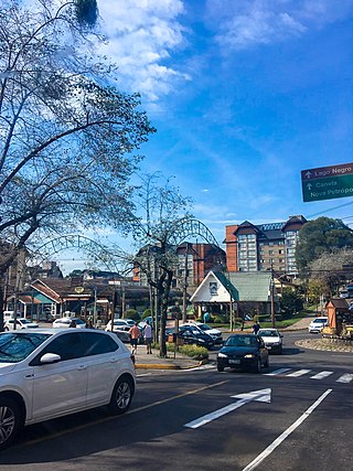
The Serra Gaúcha is a cultural region comprising the mountainous areas in the northeastern portion of Rio Grande do Sul state in southern Brazil. Most of its inhabitants are of German and Italian ancestry. Consequently, the cities in the Serra Gaúcha reflect German and Italian influences through their architecture, gastronomy, and culture. Geographically, it is part of the Serra Geral mountain range.

<span class="mw-page-title-main">Caminhos da Colônia</span> Scenic tourist route, Rio Grande do Sul, Brazil

Caminhos da Colônia, Portuguese for "Colony Pathway", is a scenic tourist route of four settlements in the Serra Gaúcha in the state of Rio Grande do Sul in southern Brazil. The 35 km route runs between the cities of Caxias do Sul, Flores da Cunha, Otávio Rocha and the old settlement of Santa Justina which never developed into a city like the other three.

<span class="mw-page-title-main">Augusto Pestana</span> Place in Rio Grande do Sul, Brazil

Augusto Pestana is a Brazilian municipality in the State of Rio Grande do Sul. It is located at 28°31′01″S 53°39′01″W, at an altitude of 390 m. The city is 320 km northwest of Porto Alegre, 1,540 km southwest of Brasília and just 120 km east of the border with Argentina.

<span class="mw-page-title-main">Languages of Brazil</span> Overview of the languages spoken in Brazil

Portuguese is the official and national language of Brazil being widely spoken by most of the population. Brazil is the most populous Portuguese-speaking country in the world, with its lands comprising the majority of Portugal’s former colonial holdings in the Americas.

<span class="mw-page-title-main">Barra Mansa</span> Municipality in Southeast, Brazil

Barra Mansa is a Brazilian municipality located in the south of the state of Rio de Janeiro.

The classification of wine is based on various criteria including place of origin or appellation, vinification method and style, sweetness and vintage, and the grape variety or varieties used. Practices vary in different countries and regions of origin, and many practices have varied over time. Some classifications enjoy official protection by being part of the wine law in their country of origin, while others have been created by, for example, growers' organizations without such protection.

<span class="mw-page-title-main">Morro Reuter</span> Municipality in Rio Grande do Sul, Brazil

Morro Reuter is a municipality in the state of Rio Grande do Sul, Brazil. Nestled in the Atlantic Forrest and located on the foothills of the Serra do Mar, it is considered the first step of the Serra Gaúcha.

Nova Bassano is a municipality and a city in the state of Rio Grande do Sul, south Brazil.

<span class="mw-page-title-main">Guaporé, Rio Grande do Sul</span> Municipality in South, Brazil

Guaporé is a Brazilian municipality located in the state of Rio Grande do Sul. It is the state's greatest jewelry and lingerie producer, ranking second in the country. The city was mainly colonized by Italian immigrants in the 19th century and still retains their traditions. The name comes from the Guaraní language and its meaning is disputed, most likely being Desert Valley.

<span class="mw-page-title-main">Demographics of Brazil</span>

Brazil had an official resident population of 203 million in 2022, according to IBGE. Brazil is the seventh most populous country in the world, and the second most populous in the Americas and Western Hemisphere.

<span class="mw-page-title-main">Italian Brazilians</span> Brazilians of Italian birth or descent

Italian Brazilians are Brazilians of full or partial Italian descent, whose ancestors were Italians who emigrated to Brazil during the Italian diaspora, or more recent Italian-born people who've settled in Brazil. Italian Brazilians are the largest number of people with full or partial Italian ancestry outside Italy, with São Paulo being the most populous city with Italian ancestry in the world. Nowadays, it is possible to find millions of descendants of Italians, from the southeastern state of Minas Gerais to the southernmost state of Rio Grande do Sul, with the majority living in São Paulo state and the highest percentage in the southeastern state of Espírito Santo (60-75%). Small southern Brazilian towns, such as Nova Veneza, have as much as 95% of their population of Italian descent.

<span class="mw-page-title-main">Nova Milano</span> Historic site on the municipality of Farroupilha, Brazil.

Nova Milano is a historic site and the seat of the fourth district of the Brazilian municipality of Farroupilha, considered the birthplace of Italian colonization in the state of Rio Grande do Sul. Originally the headquarters of the Caxias Colony, a pavilion was set up there in 1875 to welcome the immigrants who were waiting to be placed in the colonies in the region. In 1876 the colonial headquarters was transferred to Campo dos Bugres, but Nova Milano, on the margins of a very busy road, became a village, and in 1902 became the headquarters of the third district of Caxias. The arrival of railroads in 1910 determined a reorganization in the road and economic structure of the region, harming the growth of Nova Milano, which in 1934 was incorporated to the new municipality of Farroupilha as its fourth district, remaining until today with mainly rural characteristics.

<span class="mw-page-title-main">Italian immigration in Rio Grande do Sul</span> State in Southern Brazil

Italian immigration in Rio Grande do Sul was a process in which Italians emigrated to the southern state of Rio Grande do Sul, Brazil, through both private and government initiatives.

References

Notes
  1. IBGE 2020
  2. "Archived copy" (PDF). United Nations Development Programme (UNDP). Archived from the original (PDF) on July 8, 2014. Retrieved August 1, 2013.{{cite web}}: CS1 maint: archived copy as title (link)
  3. Garibaldi Official Site - City Profile Archived 2007-07-19 at the Wayback Machine , Original language: Portuguese. Translated on 28 February 2009.
  4. Garibaldi Official Site - Economic Information Archived 2007-07-19 at the Wayback Machine , Original language: Portuguese. Translated on 28 February 2009.
  5. Garibaldi Official Site - Tourist Routes Archived 2007-07-19 at the Wayback Machine , Original language: Portuguese. Translated on 28 February 2009.
  6. "Climatologia de Garibaldi - RS" (in Portuguese). Clic RBS. Retrieved 4 August 2011.