Related Research Articles

The Orange River is a river in Southern Africa. It is the longest river in South Africa. With a total length of 2,432 km (1,511 mi), the Orange River Basin extends from Lesotho into South Africa and Namibia to the north. It rises in the Drakensberg mountains in Lesotho, flowing westwards through South Africa to the Atlantic Ocean. The river forms part of the international borders between South Africa and Lesotho and between South Africa and Namibia, as well as several provincial borders within South Africa. Except for Upington, it does not pass through any major cities. The Orange River plays an important role in the South African economy by providing water for irrigation and hydroelectric power. The river was named the Orange River in honour of the Dutch ruling family, the House of Orange, by the Dutch explorer Robert Jacob Gordon. Other names include simply the word for river, in Khoekhoegowab orthography written as !Garib, which is rendered in Afrikaans as Gariep River with the intrusion of a velar fricative in place of the alveolar click, Groote River or Senqu River, derived from ǂNū "Black". It is known in isiZulu as isAngqu.

The Highveld is the portion of the South African inland plateau which has an altitude above roughly 1500 m, but below 2100 m, thus excluding the Lesotho mountain regions to the south-east of the Highveld. It is home to some of the country's most important commercial farming areas, as well as its largest concentration of metropolitan centres, especially the Gauteng conurbation, which accommodates one-third of South Africa's population.

The Caledon River is a major river located in central South Africa. Its total length is 642 km (399 mi), rising in the Drakensberg Mountains on the Lesotho border, flowing southwestward and then westward before joining the Orange River near Bethulie in the southern Free State.

The Harts River is a northern tributary of the Vaal River, which in turn is the largest tributary of the Orange River. Its source is in the North West Province, but the greater part of its basin is located in the Northern Cape Province, which it enters a few kilometers downstream from the Taung Dam.

The Gariep Dam is located in South Africa, near the town of Norvalspont, bordering the Free State and Eastern Cape provinces. Its primary purpose is for irrigation, domestic and industrial use as well as for power generation.

The Kosi or Koshi is a transboundary river which flows through China, Nepal and India. It drains the northern slopes of the Himalayas in Tibet and the southern slopes in Nepal. From a major confluence of tributaries north of the Chatra Gorge onwards, the Kosi River is also known as Saptakoshi for its seven upper tributaries. These include the Tamur River originating from the Kanchenjunga area in the east and Arun River and Sun Kosi from Tibet. The Sun Koshi's tributaries from east to west are Dudh Koshi, Likhu Khola, Tamakoshi River, Bhote Koshi, and Indravati. The Saptakoshi crosses into northern Bihar, India where it branches into distributaries before joining the Ganges near Kursela in Katihar district. Kosi is the 3rd largest tributary of the Ganges by water discharge after Ghaghra and Yamuna.
Babia Góra National Park is one of the 23 national parks in Poland, located in the southern part of the country, in Lesser Poland Voivodeship, on the border with Slovakia. Its headquarters are located in Zawoja. A Nature Reserve which roughly covered the area of the modern-day national park was created in 1933, with the actual park established on October 30, 1954. Since 1976, it has been designated by UNESCO as a biosphere reserve.

The Hottentots Holland Mountains are part of the Cape Fold Belt in the Western Cape, South Africa. The mountain range forms a barrier between the Cape Town metropolitan area and the southern Overberg coast.
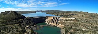
The Vanderkloof Dam is situated approximately 130 km (81 mi) downstream from Gariep Dam and is fed by the Orange River, South Africa's largest river. Vanderkloof Dam is the second-largest dam in South Africa, having the highest dam wall in the country at 108 metres (354 ft). The dam was commissioned in 1977; it has a capacity of 3,187.557 million cubic metres (2,584,195 acre⋅ft) and a surface area of 133.43 square kilometres (51.52 sq mi) when full. Other rivers flowing into this dam are the Berg River, two unnamed streams coming in from the direction of Reebokrand, the Knapsak River, Paaiskloofspruit, Seekoei River, Kattegatspruit and the Hondeblaf River, in a clockwise direction.
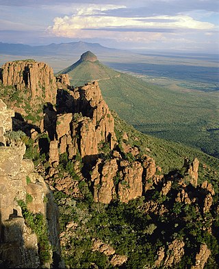
The Camdeboo National Park is located in the Karoo and almost completely surrounds the Eastern Cape town of Graaff-Reinet. It contains the Nqweba Dam.

The Orange–Fish Tunnel is a 82.8 kilometres long irrigation tunnel in central South Africa, built to divert water from the Orange River to the Fish River valley. It is the longest continuous enclosed aqueduct in the southern hemisphere.
Fort Fordyce Nature Reserve is a nature reserve in Eastern Cape Province, South Africa that is managed by Eastern Cape Parks, and has an area of 2,136 hectares.
Oviston Nature Reserve is a protected area in the Eastern Cape Province, South Africa. The nature reserve is managed by Eastern Cape Parks. It is located on the southern shores of the Gariep Dam.
Blyde River Canyon Nature Reserve is situated in the Drakensberg escarpment region of eastern Mpumalanga, South Africa. The reserve protects the Blyde River Canyon, including sections of the Ohrigstad and Blyde Rivers and the geological formations around Bourke's Luck Potholes, where the Treur River tumbles into the Blyde below. Southwards of the canyon, the reserve follows the escarpment, to include the Devil's and God's Window, the latter a popular viewpoint to the lowveld at the reserve's southern extremity.
Loskop Dam Nature Reserve is situated in northern Mpumalanga province, South Africa. The reserve covers approximately 22,850 ha, if the approximately 2,350 ha surface area of the reservoir is included. The Reserve is situated in the Olifants River valley, about 55 km north of Middelburg, and comprises a hilly bushveld region, centered on the Loskop reservoir.

Gariep Dam, founded as "Oranjekrag", is a settlement in Xhariep District Municipality in the Free State (province) of South Africa.

Venterstad is a settlement in Walter Sisulu Local Municipality in Joe Gqabi District Municipality in the Eastern Cape province of South Africa.

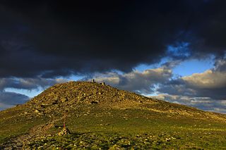
Klipriviersberg Nature Reserve is a nature reserve consisting of veld and koppies (hills) run by the Johannesburg City Parks. It is located 11 kilometres (6.8 mi) south of Johannesburg, in an area of 640 hectares. Home to many species of flora and bird life, it is also home to large and small mammals such as blesbok, zebra, wildebeest and duiker. The reserve has a number of hiking trails and archaeological sites, with the Bloubosspruit flowing through the area.
References
- ↑ "The BDI visits the Karoo Gariep Nature Reserve ..." BDI. 30 May 2019. Retrieved 9 October 2023.
- ↑ @NatGeoUK (4 April 2020). "Hitting the road in South Africa's largest province: eight spectacular routes exploring the Northern Cape". National Geographic. Retrieved 9 October 2023.

30°35′35″S25°32′04″E / 30.59299°S 25.53434°E
| | This South Africa location article is a stub. You can help Wikipedia by expanding it. |