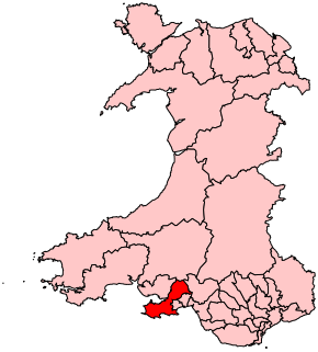
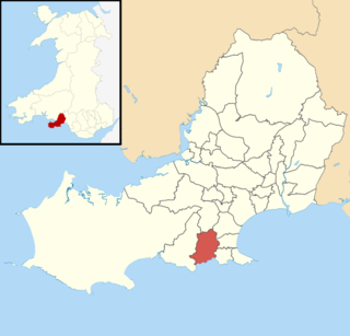
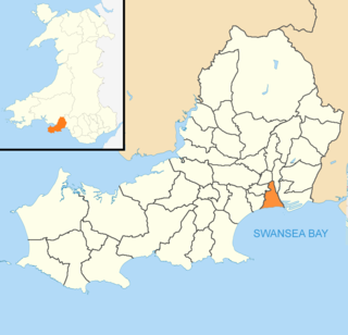
Gower is a constituency created in 1885 and represented in the House of Commons of the UK Parliament by one Member of Parliament (MP). Tonia Antoniazzi of the Labour Party became its MP after winning it from a Conservative in the 2017 UK general election. Her party had previously represented the seat from 1909 until 2015.
Dunvant is a suburban district and community (parish) in the City and County of Swansea, Wales, and falls within the Dunvant ward. It is situated in a valley some 4.5 miles west of Swansea city centre. The population as of the 2011 census was 4,383. It adjoins the area of Killay.

Newton is a village in the City of and County of Swansea, Wales. The village is located near the Mumbles just inland and uphill from Swansea Bay. The Newton ward was a part of the Mumbles community.

Mawr is a community of the City and County of Swansea, in south Wales, U.K. Mawr has its own elected community council. Its name simply means "large", and it was given the name because it was the largest piece of land in the former parish of Llangyfelach.

Penderry is the name of an electoral ward and a community in the City and County of Swansea, Wales, UK. Penderry does not have a community council.

Pennard is the name of an electoral ward in the City and County of Swansea, Wales, United Kingdom. It is coterminous with the community of Pennard.
Llwchwr is a community and electoral ward in the central western part of the City and County of Swansea, Wales, UK. It lies 9 km west-north-west of Swansea city centre and is bounded by the communities of Gorseinon to the north, Penllergaer to the east, and Gowerton to the south, as well as by the estuary of the River Loughor to the west, on the far side of which lies Bynea in Carmarthenshire, connected to Llwchwr by road and rail bridges.
Bishopston is the name of an electoral ward in the City and County of Swansea, Wales. Most of the area is rural consisting of farmland and small villages. The ward is named after the village of Bishopston which falls within the ward.

Morriston ( ) is an electoral ward in Swansea, Wales. It is coterminous with the Morriston community. Morriston is one of two five member wards in the City and County of Swansea local authority area. In population terms, it is the largest ward in the Welsh Assembly constituency of Swansea East and it is the largest ward the City and County of Swansea.
Pontarddulais is a name of an electoral ward and parish of the City and County of Swansea, south Wales. The parish of Pontarddulais has its own elected town council.
Clydach is the name of an electoral ward in the City and County of Swansea, Wales, UK.
Craig-cefn-parc is a village near Clydach, outside Swansea, Wales. It falls within the Mawr ward of Swansea. The name means "park ridge rock". Cwm Clydach RSPB nature reserve is located at the south of the village, near the New Inn Public House, at the boundary between Craig-cefn-parc and Clydach. Craig-cefn-parc is famous for its mining history with several large drift mines employing hundreds of men. In the heart of the Lower Clydach River are some of the old coal houses, there is also a coal tram located in the centre of the village to commemorate its mining history. Craig Cefn Parc school was closed in 2019. A small memorial garden was created lower down in the village for a place to reflect and sit for a while. The village has a small store, a community building and playing fields. In 2020 funding was obtained for a children's park and play area.

Cockett is the name of an electoral ward in the City and County of Swansea, Wales, UK. The ward is coterminous with the Cockett community. It elects three councillors.

Llangyfelach is an electoral ward in the county of Swansea, Wales, UK. It covers the communities of Llangyfelach and part of Mawr.
Pontardawe is the name of an electoral ward of Neath Port Talbot county borough, Wales. It is a division of the Pontardawe community and falls within the parliamentary constituency of Neath.

Pontlliw and Tircoed is a community and electoral ward in the north of the City and County of Swansea, Wales. It includes the villages of Pontlliw and Tircoed.
Castle is an electoral ward and community in the City and County of Swansea, Wales, UK. Castle covers most of the heart of the City of Swansea, with Swansea Castle at its centre.

Tawe-Uchaf is a community in Powys, Wales. Situated north-east of Ystradgynlais in the upper valley of the River Tawe, it includes the villages of Caehopkin, Coelbren, Glyntawe, Pen-y-cae, Penwyllt and Ynyswen. It had a population in 2001 of 1,516, increasing at the 2011 Census to 1,562.