
Clay County is located in the U.S. state of Missouri and is part of the Kansas City metropolitan area. As of the 2020 census, the county had a population of 253,335, making it the fifth-most populous county in Missouri. Its county seat is Liberty. The county was organized January 2, 1822, and named in honor of U.S. Representative Henry Clay from Kentucky, later a member of the United States Senate and United States Secretary of State.

Ray County is a county located in the northwestern portion of the U.S. state of Missouri and is part of the Kansas City metropolitan area. As of the 2020 census, the population was 23,158. Its county seat is Richmond. The county was organized November 16, 1820, and named for John Ray, a Missouri state legislator and member of the first state Constitutional Convention.

Adair County is a county located in the northeastern part of the U.S. state of Missouri. The population census for 2020 was 25,314. As of July 1, 2021, the U.S. Census Bureau's Population Estimates for the county is 25,185, a -0.5% change. Adair county seat is Kirksville. The county was first settled by immigrants from Kentucky and organized on January 29, 1841. Adair County comprises the Kirksville, MO Micropolitan Statistical Area.

Liberty is a city in and the county seat of Clay County, Missouri, United States and is a suburb of Kansas City, located in the Kansas City Metropolitan Area. As of the 2020 United States Census the population was 30,167. Liberty is home to William Jewell College.

Smithville is a city in Clay and Platte counties in the U.S. state of Missouri and is part of the Kansas City metropolitan area, along the Little Platte River. The population was 10,406 at the 2020 United States Census.

Sedalia is a city located approximately 30 miles south of the Missouri River and, as the county seat of Pettis County, Missouri, United States, it is the principal city of the Sedalia Micropolitan Statistical Area. As of the 2020 census, the city had a total population of 21,725. Sedalia is also the location of the Missouri State Fair and the Scott Joplin Ragtime Festival. U.S. Routes 50 and 65 intersect in the city.

William Jewell College is a private liberal arts college in Liberty, Missouri, United States. It was founded in 1849 by members of the Missouri Baptist Convention and endowed with $10,000 by William Jewell. It was associated with the Missouri Baptist Convention for over 150 years until it separated in 2003 and became independent. After becoming a nonsectarian institution, the college's enrollment fell by approximately 40% to 739 students in 2018. Jewell is accredited by the Higher Learning Commission.
This is a list of properties and historic districts in Arkansas that are listed on the National Register of Historic Places. There are more than 2,600 listings in the state, including at least 8 listings in each of Arkansas's 75 counties.

Liberty Corner is an unincorporated community and census-designated place (CDP) located in Bernards Township, in Somerset County, in the U.S. state of New Jersey. Liberty Corner is about 3+3⁄4 miles (6.0 km) south of Bernardsville. Liberty Corner has a post office with ZIP code 07938. The Liberty Corner Historic District was listed on the state and national registers of historic places in 1991.

This is a list of the National Register of Historic Places listings in Clay County, Missouri.

Harris–Stowe State University (HSSU) is a public university. It is in St. Louis, Missouri. It is an HBCU, a historically Black university. The university offers 50 majors, minors, and certificate programs in education, business, and arts & sciences. It is a member-school of the Thurgood Marshall College Fund. It is immediately east of the Saint Louis University campus. The school enrolled 1,098 students in 2023.

Frank Hughes Memorial Library is a historic library building located at Liberty, Clay County, Missouri. It was designed by the architectural firm Wight and Wight and built in 1940. It is a one-story, rectangular Classical Revival style brick building. It has a gable roof with a wide elaborate cornice. It features a flat-roofed portico feature a wide, simple wood entablature topped with a rooftop balustrade.

Arthur–Leonard Historic District is a national historic district located at Liberty, Clay County, Missouri. It encompasses 36 contributing buildings in a predominantly residential section of Liberty. The district developed between about 1868 and 1946, and includes representative examples of Greek Revival, Queen Anne, Prairie School, and Bungalow / American Craftsman style residential architecture.

Dougherty–Prospect Heights Historic District is a national historic district located at Liberty, Clay County, Missouri. It encompasses 139 contributing buildings in a predominantly residential section of Liberty. The district developed between about 1850 and 1946, and includes representative examples of Greek Revival, Queen Anne, Tudor Revival, Prairie School, American Foursquare / Shirtwaist and Bungalow / American Craftsman style residential architecture.

Jewell-Lightburne Historic District is a national historic district located at Liberty, Clay County, Missouri. It encompasses 236 contributing buildings in a predominantly residential section of Liberty. The district developed between about 1852 and 1946, and includes representative examples of Greek Revival, Queen Anne, Tudor Revival, Prairie School, and Bungalow / American Craftsman style residential architecture. Located in the district is the separately listed Frank Hughes Memorial Library.
South Liberty Courthouse Square Historic District is a national historic district located at Liberty, Clay County, Missouri. It encompasses nine contributing buildings in the central business district of Liberty. The district developed between about 1875 and 1942, and includes representative examples of Classical Revival, Late Victorian, and Modern Movement style architecture. Notable buildings include the Clay County Courthouse (1935–1936) by Wight and Wight and First National Bank (1923).
West Liberty Courthouse Square Historic District is a national historic district located at Liberty, Clay County, Missouri. It encompasses three contributing buildings in the central business district of Liberty. The adjoining buildings were built between 1877 and 1885, and are representative examples of Italianate style commercial architecture.

Odd Fellows Home District is a national historic district located at Liberty, Clay County, Missouri. It encompasses three contributing buildings, one contributing site, and four contributing structures associated with an institutional home and hospital. The district developed between about 1900 and 1935, and representative examples of Tudor Revival and Jacobethan Revival architecture. The contributing buildings are the Administration Building, the Old Folks Building (1907-1908), and the Old Hospital (1923). Also on the property is the historic Odd Fellows Home Cemetery.

The Elms Historic District is a national historic district located at Excelsior Springs, Clay County, Missouri, United States. It encompasses 31 contributing buildings, 1 contributing site, and 7 contributing structures in a predominantly residential section of Excelsior Springs. The district developed between about 1887 and 1963, and includes representative examples of Gothic Revival, Tudor Revival, and Bungalow style architecture. It is anchored by the separately listed Elms Hotel and consists of two historic residential plats: the Central Park and the Elms Addition.
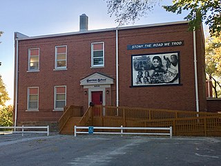
Garrison School was a school for African American students in Liberty, Missouri. The school was named for William Lloyd Garrison, an abolitionist who served in U.S. President Abraham Lincoln’s cabinet. One of the school's former buildings is now a cultural center. It is part of the National Register of Historic Places, since it is listed Garrison School Historic District. A historical marker was placed and dedicated in front of the school building in 2020.


