Bassano is a town in Alberta, Canada. It is located on the Trans-Canada Highway approximately 140 kilometres (87 mi) southeast of Calgary and 160 kilometres (99 mi) northwest of Medicine Hat. It is also on the main line of the Canadian Pacific Kansas City. A short distance south of the town is the Bassano Dam, serves as a diversion structure which routes water through a canal into Lake Newell Reservoir which supplies water to the majority of the County of Newell for purposes like irrigation, recreation, and the County's drinking water.

The District of Alberta was one of four districts of the Northwest Territories created in 1882. It was styled the Alberta Provisional District to distinguish it from the District of Keewatin which had a more autonomous relationship from the NWT administration. Present-day Province of Alberta takes in the District of Alberta and parts of the Districts of Athabasca, Assiniboia and Saskatchewan. Alberta became a province in 1905.

The County of Stettler No. 6 is a municipal district in central Alberta, Canada.
Endiang is a hamlet in Alberta, Canada within the County of Stettler No. 6. It is located approximately 80 kilometres (50 mi) southeast of Stettler.
There are several lakes named Mud Lake within the Canadian province of Alberta.
Byemoor is a hamlet in Alberta, Canada within the County of Stettler No. 6. It is located at the intersection of Highway 853 and Highway 589, approximately 70 kilometres (43 mi) southeast of Stettler and 80 kilometres (50 mi) northeast of Drumheller. It has an elevation of 845 metres (2,772 ft).

Horseshoe Canyon is a region of badlands surrounded by prairie in the province of Alberta, Canada. It is located about 17 km (11 mi) west of the town of Drumheller, Alberta, along Highway 9.

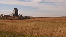
Retlaw is an unincorporated community located in the Municipal District of Taber, Alberta, Canada. The community once had a peak population of over 250 citizens and was even incorporated under the status of a village until it was dissolved into a hamlet under the jurisdiction of Improvement District No. 96 on March 1, 1939. Retlaw is located 2 km (1 mi) west of Highway 864 6 km (3 mi) west of Vauxhall and 42 km (26 mi) northwest of Taber and 75 km (46 mi) southwest of Brooks.

Rowley is a hamlet In Alberta, Canada within Starland County. It is located just north of Drumheller.

Cherhill is a hamlet in Alberta, Canada within Lac Ste. Anne County. It is located along Highway 43, approximately 35 kilometres (22 mi) east of Mayerthorpe and 82 kilometres (51 mi) northwest of Edmonton.
Bush Pass is a mountain pass in the Canadian Rockies, on the border between the Canadian provinces of Alberta and British Columbia. It is located at the headwaters of the Valenciennes River, formerly known as the South Fork Bush River; the North Fork Bush River is now known as the Bush River.
Simpson Pass, el. 2,107 m (6,913 ft), is a mountain pass on the border between the Canadian provinces of Alberta and British Columbia, in the area of the Ball Range. It is the prominence col for Mount Ball on the Continental Divide in the vicinity of Sunshine Village ski resort. Simpson River and Simpson Pass are named after Sir George Simpson who first explored the area in 1841.
Finnegan is an unincorporated community in southern Alberta in Special Area No. 2, located 14 kilometres (8.7 mi) west of Highway 36, 64 kilometres (40 mi) northwest of Brooks.
Hand Hills was a provincial electoral district in Alberta mandated to return a single member to the Legislative Assembly of Alberta from 1913 to 1963. It was abolished prior to the 1963 Alberta general election due to redistribution, in favour of the new electoral district of Hand Hills-Acadia.
Gatine is a locality in Alberta, Canada.
Fincastle is a locality in Alberta, Canada. It is located east of Taber in the southeastern portion of the province.

Horsethief Canyon is found 16 kilometres (9.9 mi) northwest of the town of Drumheller, in Starland County in the province of Alberta, Canada. It is on the east bank of the Red Deer River, along Highway 838. Both Horsethief Canyon and Horseshoe Canyon are distinctive features of the surrounding badlands of central Alberta. Although the two canyons look similar, they are separated by several kilometres and were created by different tributaries of the Red Deer River.
Ghostpine Creek is a stream in Alberta, Canada.
Hand Hills is a range of hills in Alberta, Canada.
Hand Hills-Acadia was a provincial electoral district in Alberta, Canada, mandated to return a single member to the Legislative Assembly of Alberta using the first-past-the-post method of voting from 1963 to 1971. It was formed prior to the 1963 Alberta general election from the previous electoral district of Hand Hills.