Gatcombe, Somerset

Last updated

Gatcombe
Geograph 2675312 Gatcombe Court.jpg
Location Long Ashton, Somerset, England
Coordinates 51°25′32″N2°40′56″W / 51.42556°N 2.68222°W / 51.42556; -2.68222
Official nameRoman settlement, part of an associated field system and earlier Iron Age settlement remains at Gatcombe Farm
Designated5 December 1955 [1]
Reference no.1011978
Listed Building – Grade II*
Official nameGatcombe Court
Designated16 March 1984 [2]
Reference no.1137925
Somerset UK location map.svg
Red pog.svg
Location of Gatcombe in Somerset

Gatcombe at Ashton Watering within the civil parish of Long Ashton, Somerset, England, is the location of a Grade II* listed building [2] which was built on the site of a Roman settlement.

Contents

It is close to the Land Yeo river, the A370 road and the Bristol to Exeter railway line.

Roman settlement

Roman remains were first identified at the site in 1839 when a railway cutting was being constructed. [3] Excavations in the 1960s showed that the site was occupied from the middle of the 1st century until at least the fifth century, demonstrated by the coins of Theodosius, Magnus Maximus and Arcadius which have been found. The full extent of the site is unclear, beyond a specific villa but there is some evidence that the site is much more extensive, possibly forming a village or even a town. It has been speculated that this may be the site of Iscalis as described by Ptolemy, [4] however it has also been suggested this may have been at Charterhouse Roman Town. [5]

The Roman site had a 15 feet (4.6 m) wide wall around it, [6] enclosing an area of around 16 acres (6.5 ha), although this is obscured on the southern side near the railway line, [4] A 60 feet (18 m) deep well has also been uncovered. [6]

At least nineteen agricultural buildings have been identified within the enclosure. In addition one building at the southern end of the site included a colonnade and mosaic and other features suggesting it was a sizeable Roman villa. [3] A magnetometry survey conducted during 2009 and 2010 identified several likely buildings outside the enclosed area. [7]

The site was connected to Abbots Leigh by a Roman road. [8]

Current building

Gatcombe Court was built in the late 14th century, [2] based on a solar built by John de Gatcombe before 1254. [9] The house was further altered in the late 17th century and again in the 20th century. [10] The two-storey house has tiled roofs with attics into two steep gables. [2]

The garden includes a yew hedge which is believed to be 400 years old and a recently added Roman herb garden designed by Jekka McVicar. [6] Near the house is an old mill on the Land Yeo. There is evidence of a snuff mill at the site in 1769, however the current building dates from the early 19th century. By 1846 it had been converted to grind mustard, annatto and drugs, but by 1874 was a flour mill. [11] The internal machinery is still in place and the mill has been designated as a Grade II listed building. [12]

It was the family home of the Somerset Cricketer Osbert Mordaunt and then the family of Charles Clarke, of the Bristol law firm Osborne Clarke. It is now home to Stella Clarke. [6]

In the 17th century a farmhouse was built on the site. This was altered in the 19th century. [13]

Related Research Articles

<span class="mw-page-title-main">Clevedon</span> Town and civil parish in Somerset, England

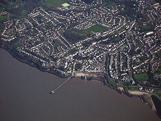
Clevedon is a seaside town and civil parish in the unitary authority of North Somerset, England. It recorded a parish population of 21,281 in the United Kingdom Census 2011, estimated at 21,442 in 2019. It lies along the Severn Estuary, among small hills that include Church Hill, Wain's Hill, Dial Hill, Strawberry Hill, Castle Hill, Hangstone Hill and Court Hill, a Site of Special Scientific Interest with overlaid Pleistocene deposits. It features in the Domesday Book of 1086. Clevedon grew in the Victorian period as a seaside resort.

<span class="mw-page-title-main">Long Ashton</span> Human settlement in England

Long Ashton is a village and civil parish in Somerset, England. It falls within the unitary authority of North Somerset and is one of a number of large villages just outside the boundary of city of Bristol urban area. The parish has a population of 6,044. The parish includes the hamlet of Yanley, and the residential area of Leigh Woods.

<span class="mw-page-title-main">Ashton Court</span> Mansion house and estate to the west of Bristol in England

Ashton Court is a mansion house and estate to the west of Bristol in England. Although the estate lies mainly in North Somerset, it is owned by the City of Bristol. The mansion and stables are a Grade I listed building. Other structures on the estate are also listed.

<span class="mw-page-title-main">Barrow Gurney</span> Human settlement in England

Barrow Gurney is a village and civil parish in Somerset, England, situated in the unitary authority of North Somerset on the B3130, midway between the A38 and A370 near the Long Ashton bypass and Bristol Airport, 5 miles (8.0 km) south west of Bristol city centre. The civil parish includes Barrow Common, and has a population of 349.

<span class="mw-page-title-main">Flax Bourton</span> Human settlement in England

Flax Bourton is a village and civil parish in Somerset, England. The parish, with a population of 715, is situated within the unitary authority of North Somerset, on the edge of Nailsea Moor on the A370 road 5 miles (8.0 km) south west of Bristol city centre.

<span class="mw-page-title-main">Wraxall, Somerset</span> Human settlement in England

Wraxall is a village in North Somerset, England, about 6 miles (10 km) west of Bristol. Until 1811 the parish of the same name also included Nailsea and Flax Bourton. The village is now within the parish of Wraxall and Failand.

<span class="mw-page-title-main">Clapton in Gordano</span> Human settlement in England

Clapton in Gordano is a village and civil parish in Somerset, England. It is situated within the unitary authority of North Somerset on the southern side of the Gordano Valley, immediately adjacent to the M5 motorway. The parish has a population of 348. There is a village football club, Clapton in Gordano FC. They currently run two sides with a view to continue progressing throughout the leagues. Their home ground is currently Clapton Lane, Portishead.

<span class="mw-page-title-main">Walton in Gordano</span> Human settlement in England

Walton in Gordano is a village and civil parish in North Somerset, England. It is situated in a small valley at the side of the south-western end of the Gordano Valley, about a mile from Clevedon. The parish has a population of 273.

<span class="mw-page-title-main">Camerton, Somerset</span> Human settlement in England

Camerton is a village and civil parish in Somerset, 6 miles (9.7 km) south west of Bath, lying on the Cam Brook. The parish has a population of 655.

<span class="mw-page-title-main">Brockley, Somerset</span> Human settlement in England

Brockley is a village and civil parish in Somerset, England. The parish is within the unitary authority of North Somerset, about 3 miles (4.8 km) south of Nailsea, and includes the village of Chelvey. According to the 2011 census it had a population of 277.

<span class="mw-page-title-main">Priston</span> Human settlement in England

Priston is a civil parish and village 4 miles (6 km) south west of Bath in Bath and North East Somerset, which is within the English ceremonial county of Somerset. The parish includes the hamlet of Wilmington.

<span class="mw-page-title-main">Timsbury, Somerset</span> Human settlement in England

Timsbury is a village and civil parish in England, in the Bath and North East Somerset unitary authority of the county of Somerset. It lies 8 miles (13 km) south-west of Bath, close to the Cam Brook river. The parish, which includes the hamlets of Radford and Wall Mead, and part of Meadgate hamlet, had a population of 2,624 in 2011.

<span class="mw-page-title-main">Cleeve, Somerset</span> Human settlement in England

Cleeve is a village and civil parish in the ceremonial county of Somerset, England. It is situated within the unitary authority of North Somerset, 9 miles (14 km) south west of Bristol and has a population of 902.

Iscalis was a Roman settlement described by Ptolemy. The exact location has not been clearly identified but the possible sites are in the modern ceremonial county of Somerset, England.

<span class="mw-page-title-main">Grade I listed buildings in Somerset</span> Buildings of exceptional interest in Somerset

The Grade I listed buildings in Somerset, England, demonstrate the history and diversity of its architecture. The ceremonial county of Somerset consists of a non-metropolitan county, administered by Somerset County Council, which is divided into five districts, and two unitary authorities. The districts of Somerset are West Somerset, South Somerset, Taunton Deane, Mendip and Sedgemoor. The two administratively independent unitary authorities, which were established on 1 April 1996 following the breakup of the county of Avon, are North Somerset and Bath and North East Somerset. These unitary authorities include areas that were once part of Somerset before the creation of Avon in 1974.

<span class="mw-page-title-main">Cheddar Yeo</span> River in Somerset, England

The Cheddar Yeo is a small river in Somerset, England. Beneath the limestone of the Mendip Hills it forms the largest underground river system in Britain. After emerging into Cheddar Gorge it flows through the village of Cheddar, where it has been used in the past to power mills. From the Middle Ages until the 19th century the river had ports for seagoing vessels but is no longer navigable. Some of the water, which is of good quality, is diverted into Cheddar Reservoir to provide drinking water for Bristol.

<span class="mw-page-title-main">Land Yeo</span> River in north Somerset, England

The Land Yeo is a small river which flows through North Somerset, England. It rises on Dundry Hill and supplies Barrow Gurney Reservoirs before flowing through various villages to Clevedon where it drains into the Severn Estuary. During the past 1,000 years it has powered at least ten watermills, however only one is still functional. Since 2003 initiatives have been undertaken to clean up the river, improving water quality and encouraging wildlife.

References

  1. Historic England. "Roman settlement, part of an associated field system and earlier Iron Age settlement remains at Gatcombe Farm (1011978)". National Heritage List for England . Retrieved 29 October 2023.
  2. 1 2 3 4 "Gatcombe Court". historicengland.org.uk. English Heritage . Retrieved 30 April 2011.
  3. 1 2 "Gatcombe Settlement". National Monuments Record. English Heritage . Retrieved 30 April 2011.
  4. 1 2 Cunliffe, Barry (1967). "Excavations at Gatcombe, Somerset, in 1965 and 1966" (PDF). Proceedings of the University of Bristol Spelæological Society. 11 (2): 126–160. Retrieved 30 April 2011.
  5. Rivet, A. L. F.; Smith, Colin (1979). The Place-Names of Roman Britain. London: B. T. Batsford.
  6. 1 2 3 4 jpazucha (15 August 2008). "Tea and history". Western Daily Press. Archived from the original on 5 May 2013. Retrieved 30 April 2011.
  7. Smisson; The Gatcombe Environs Research Team, RPM. "Extract from Gatcombe Roman Settlement Geophysical Surveys 2009/2010 Second Progress Report North of the Railway" (PDF). Yatton, Congresbury, Claverham and Cleeve Archaeological Research Team. Retrieved 21 October 2017.
  8. "Roman Road from Gatcombe to Abbot's Leigh". National Monuments Record. English Heritage . Retrieved 30 April 2011.
  9. "Gatcombe Court". Gatcombe Court. Retrieved 30 April 2011.
  10. "Gatcombe Court". National Monuments Record. English Heritage . Retrieved 30 April 2011.
  11. Bodman, Martin. "Mills on the Land Yeo" (PDF). Nailsea and District Local History Society. Retrieved 28 April 2011.
  12. "Gatcombe Mill". historicengland.org.uk. English Heritage . Retrieved 29 April 2011.
  13. "Gatcombe Farm". National Monuments Record. English Heritage . Retrieved 30 April 2011.