
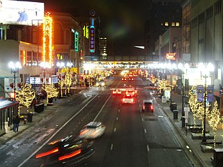
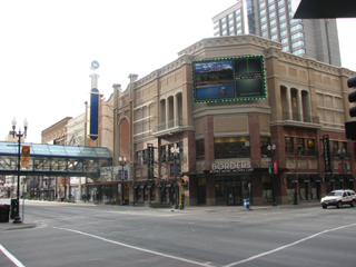
Nicollet Mall is a twelve-block portion of Nicollet Avenue running through downtown Minneapolis, Minnesota, United States. It is the shopping and dining district of the city, and also a pedestrian and transit mall. Along with Hennepin Avenue to the west, Nicollet Mall forms a cultural and commercial center of Minneapolis.
Nicollet Avenue is a major street in Minneapolis, Richfield, Bloomington, and Burnsville in the U.S. state of Minnesota. It passes through a number of locally well-known neighborhoods and districts, notably Eat Street in south Minneapolis and the traffic-restricted Nicollet Mall in downtown Minneapolis.
The city of Minneapolis, Minnesota, United States is officially defined by the Minneapolis City Council as divided into eleven communities, each containing multiple official neighborhoods. Informally, there are city areas with colloquial labels. Residents may also group themselves by their city street suffixes, North, Northeast, South, Southeast, and Southwest.

Nicollet Island is an island in the Mississippi River just north of Saint Anthony Falls in central Minneapolis, Minnesota. According to the United States Census Bureau the island has a land area of 194,407 square metres (0.075 sq mi) and a 2000 census population of 144 persons. The island makes up a large part of the city-designated Nicollet Island/East Bank neighborhood. The island is named for cartographer Joseph Nicollet, who mapped the Upper Mississippi in the 1830s.

Lowry Hill East is a neighborhood in southwest Minneapolis, Minnesota, United States, part of the Calhoun Isles community. It is bounded on the east by Lyndale Avenue, on the west by Hennepin Avenue and on the south by Lake Street. Lyndale and Hennepin intersect on the northern side at Interstate 94. This creates a neighborhood roughly triangular in shape, which is how it gets its nickname, "the Wedge." It is part of a larger area south of Franklin Avenue and west of Nicollet Avenue that is often considered Uptown, although officially Uptown is a smaller area centered on the intersection of Hennepin and Lake.

The Federal Reserve Bank of Minneapolis, located in Minneapolis, Minnesota, in the United States, covers the 9th District of the Federal Reserve, which is made up of Minnesota, Montana, North and South Dakota, northwestern Wisconsin, and the Upper Peninsula of Michigan. Although its geographical territory is the third largest of the 12 Federal Reserve banks, it serves the smallest population base of the system. It has one branch, which is in Helena, Montana.

Saint Anthony Main refers to an area of buildings with multiple owners located on Main Street across from St Anthony falls in the Nicollet Island/East Bank, Minneapolis section of Southeast, Minneapolis in the U.S. state of Minnesota. Commonly the area is associated with Northeast, Minneapolis as it is actually northeast of downtown on the east side of the Mississippi River. It opened as a festival marketplace in the 1980s.
Hennepin Avenue is a major street in Minneapolis, Minnesota, United States. It runs from Lakewood Cemetery, north through the Uptown District of Southwest Minneapolis, through the Virginia Triangle, the former "Bottleneck" area west of Loring Park. It then goes through the North Loop in the city center, to Northeast Minneapolis and the city's eastern boundary, where it becomes Larpenteur Avenue as it enters Lauderdale in Ramsey County at Highway 280. Hennepin Avenue is a Minneapolis city street south/west of Washington Avenue, and is designated as Hennepin County Road 52 from Washington Avenue to the county line.

Stadium Village is an area of Minneapolis, Minnesota near the East Bank campus of the University of Minnesota. While not an official neighborhood of Minneapolis, the area is an important commercial district that serves university students with many bars and restaurants. There are plans to incorporate it into an official neighborhood of Minneapolis along with the surrounding area. It is part of Southeast Minneapolis, that part of Minneapolis on the East Bank of the Mississippi River and south of Hennepin Avenue

The Hennepin County Law Library is a law library located in Minneapolis, Minnesota, founded in 1883.
Nicollet Island/East Bank is a neighborhood in Minneapolis, Minnesota, situated just across the Mississippi River from Downtown, one of six in the University community. It comprises Nicollet Island and the portion of the eastern riverbank located between Central Avenue and the Burlington Northern-Santa Fe Railroad line. The "East Bank" portion of the neighborhood is commonly referred to as a part of Northeast or Old St. Anthony, as this area was the location of the town of St. Anthony, which was annexed by Minneapolis in 1872.
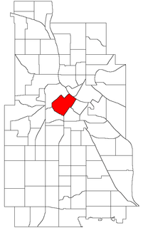
Downtown West is an official neighborhood in Minneapolis, part of the larger Central community. It is the heart of downtown Minneapolis, containing the bulk of high-rise office buildings in the city, and is what comes to mind when most Minneapolitans think of "downtown". Its boundaries are as follows : 12th Street to the southwest, 3rd Avenue North, Washington Avenue North, and Hennepin Avenue to the northwest, the Mississippi River to the northeast, and Portland Avenue, 5th Street South, and 5th Avenue South to the southeast. It is bordered by the North Loop, Nicollet Island/East Bank, Downtown East, Elliot Park, and Loring Park neighborhoods. Downtown West is home to most of Minneapolis's most notable buildings like the Foshay Tower and IDS Center. Being next to the neighborhood Loring Park which has a substantial population of gay people, it is unsurprising that Downtown West has a few gay bars such as The Saloon.
Block E is a block in downtown Minneapolis bounded by Hennepin Avenue, 6th Street, 7th Street, and 1st Avenue North. It is part of the Downtown West neighborhood in Minneapolis. It is one block south of the Warehouse District/Hennepin Avenue light rail station on the METRO Blue and Green lines.
Washington Avenue is a major thoroughfare in Minneapolis, Minnesota, United States. Starting north of Lowry Avenue, the street runs straight south, with Interstate 94 running alongside it until just south of West Broadway, when the freeway turns to the west. Washington continues running straight until just south of Plymouth Avenue, where it turns in a southeasterly direction heading for Downtown Minneapolis. It forms the main thoroughfare through the Warehouse District.

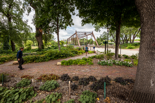
The Mill District is a neighborhood within Minneapolis, Minnesota, United States, and a part of the larger Downtown East neighborhood. Its approximate boundaries are the Mississippi River to the north, the I-35W Mississippi River bridge to the east, Washington Avenue to the south, and 5th Avenue to the west. It is bounded by Downtown West as well as the rest of the Downtown East neighborhoods. The Marcy-Holmes neighborhood is on the other side of the river, but there is no direct automobile connection between the two neighborhoods. There is a pedestrian and bicycle connection via the Stone Arch Bridge.

The Minneapolis Great Northern Depot, also known as Great Northern Station, was a passenger railroad station which served Minneapolis, Minnesota, USA. It was built in 1913 and demolished in 1978. It was located on Hennepin Avenue next to the Hennepin Avenue Bridge and across the street from the main Minneapolis Post Office.

The Minneapolis Post Office is the central post office for the city of Minneapolis, Minnesota in the United States. Located on the west bank of the Mississippi River, the facility extends west to east from Hennepin Avenue Bridge to the Third Avenue Bridge and north to south from the West River Parkway on the Grand Rounds Scenic Byway to First Street. Its ZIP code is 55401.

Minneapolis Central Library, a library in downtown Minneapolis, Minnesota, United States, is the largest library of the Hennepin County Library public library system. It bills itself as having "the third largest per capita public library collection of any major city in America with a collection of more than 2.4 million items—including books, DVDs, music, government documents." The 353,000-square-foot (32,800 m2) building at 300 Nicollet Mall with two levels of underground parking was designed by César Pelli and opened on May 20, 2006. It has over 300 computers for use by the public, an 8,140-square-foot (756 m2) atrium, an 18,560-square-foot (1,724 m2) green roof planted with low-growing ground cover designed to "be sun- and drought-resistant", and a host of energy-efficiency measures.

The Northwestern National Life Insurance Company Home Office, was also known as the Loring Park Office Building, and is now a 75 unit boutique apartment complex known as 430 Oak Grove located in Minneapolis, Minnesota. It was designed by the architecture firm of Hewitt and Brown in the Beaux-Arts style. The building was listed on the National Register of Historic Places on July 16, 2012.

The Nicollet Hotel, in downtown Minneapolis, was located on a slightly irregular block bounded by Hennepin Avenue, Washington Avenue, Nicollet Avenue and 3rd Street South adjacent to Gateway Park.


