Air Vanuatu is an airline with its head office in Air Vanuatu House, Port Vila, Vanuatu. It is Vanuatu's national flag carrier, formerly operating to Australia, New Zealand, New Caledonia and points in the South Pacific. Its main base is Bauerfield International Airport, Port Vila. In May 2024 operations ceased with the airline placed into liquidation by the Government of Vanuatu. Limited domestic services resumed in August 2024.

Torba is the northernmost and least populous province of Vanuatu. It consists of the Banks Islands and the Torres Islands.
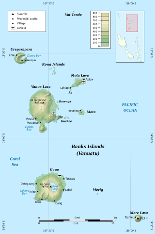
The Banks Islands are a group of islands in northern Vanuatu. Together with the Torres Islands to their northwest, they make up the northernmost province of Torba. The island group lies about 40 km (25 mi) north of Maewo, and includes Gaua and Vanua Lava, two of the 13 largest islands in Vanuatu. In 2009, the islands had a population of 8,533. The island group's combined land area is 780 km2 (300 sq mi).

Gaua is the largest and second most populous of the Banks Islands in Torba Province in northern Vanuatu. It covers 342 km2.
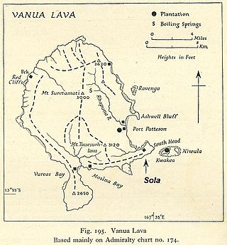
Vanua Lava is the second largest of the Banks Islands in Torba Province, Vanuatu, after slightly larger Gaua.

Mota Lava or Motalava is an island of the Banks group, in the north of Vanuatu. It forms a single coral system with the small island of Ra.
Mota Lava Airport is an airport located on the island of Mota Lava, one of the Banks Islands in the Torba province in Vanuatu. Also known as Valua Airport, it is located on the eastern end of Motalava island, near the village of Aplow.
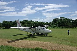
Vanua Lava Airport, also known as Sola Airport, is an airport near Sola on the island of Vanua Lava, one of the Banks Islands in the Torba province in Vanuatu.
Torres Airport is an airfield serving the Torres Islands in the Torba province in Vanuatu. It is located on Linua island, just north of Lo island.

Hiw is the northernmost island in Vanuatu, located in Torba Province.

Severe Tropical Cyclone Funa was the second strongest tropical cyclone during the 2007–08 South Pacific cyclone season, causing heavy flood and wind damage to areas of Vanuatu. The third tropical cyclone and second severe tropical cyclone of the season to form to the west of 160°E, Funa formed from an area of disturbed weather within the monsoon trough northeast of Vanuatu on January 16, 2008. Steadily intensifying as it moved to the east and subsequently south, Funa reached peak intensity with 10-minute sustained winds of 175 km/h (110 mph). However, the cyclone encountered unfavorable conditions as it progressed further south, before transitioning into an extratropical cyclone on January 21.

Merelava is an island in the Banks Islands of the Torba Province of northern Vanuatu.
Merig is a small island located 20 kilometres east of Gaua, in the Banks Islands of northern Vanuatu.
Koro is an Oceanic language spoken on Gaua island in Vanuatu. Its 280 speakers live in the village of Koro, on the south coast of Gaua.
Dorig(formerly called Wetamut) is a threatened Oceanic language spoken on Gaua island in Vanuatu.
Nume is an Oceanic language spoken on Gaua island in Vanuatu. Its 700 speakers live on the northeast coast of Gaua.
Olrat was an Oceanic language of Gaua island, in northern Vanuatu. It became extinct in 2009, with the death of its last speaker Maten Womal.
Ngwel is an uninhabited island in Torba Province of Vanuatu in the Pacific Ocean. The island is a part of the Torres Islands archipelago.
Leneu is a small uninhabited island in Torba Province of Vanuatu in the Pacific Ocean. Leneu lies close to Sola on Vanua Lava and is a part of Banks Islands archipelago.