Gee Cross

Last updated

Gee Cross
Gee Cross signpost.jpg
Gee Cross village centre
Greater Manchester UK location map 2.svg
Red pog.svg
Gee Cross
Location within Greater Manchester
OS grid reference SJ9593
Metropolitan borough
Metropolitan county
Region
Country England
Sovereign state United Kingdom
Post town Hyde
Postcode district SK14
Dialling code 01611
Police Greater Manchester
Fire Greater Manchester
Ambulance North West
UK Parliament
List of places
UK
England
Greater Manchester
53°26′17″N2°04′04″W / 53.4380°N 2.0677°W / 53.4380; -2.0677

Gee Cross is a village and suburb of Hyde within Tameside Metropolitan Borough, in Greater Manchester, England.

Contents

History

Gee Cross well dressing festival, 2003 Gee Cross Well Dressing 2003 - geograph.org.uk - 1071853.jpg
Gee Cross well dressing festival, 2003

Gee Cross village centre dates back to the times of the Domesday Book. Originally, Gee Cross was the larger village in the immediate area; however, Hyde grew during the Industrial Revolution and is now the major town, having merged into the north of Gee Cross. [1]

The village contains modern day Hyde's first place of Christian worship, Hyde Chapel, built in 1708. This would serve as the main church in the area for over a century until St George's Church was built in the centre of Hyde in 1832. [1]

Historically, the village, latterly as part of the borough of Hyde, was a part of Cheshire until the creation of Greater Manchester in 1974. The village has neither statutory boundaries nor civil parish status. Tradition would dictate that the northern boundary is at a location known as the Big Tree, just past Lilly Street, which now commemorates those that lost their lives in the Falklands War of 1982.

Gee Cross is home to a recently instituted well dressing festival, which is an ancient custom in the Pennines. Another recent addition is the annual village fete, which is a major fundraising event for local charities; it is held on the site of the former reservoir, the Queen Adeleide Reservoir, now known as Sam Redfern Green, which is now classified as the village green.

Geography

Werneth Low Werneth Low from near Windy Harbour.JPG
Werneth Low

Gee Cross is built on the side of a hill called Werneth Low, a part of the Pennines, which surrounds the village to the south and east. Werneth Low is a protected country park that was first created as a war memorial by the people of Hyde. The park has a visitors centre and ranger service. On a clear day, there are views across the Greater Manchester, as well as Lancashire and Merseyside; the Welsh mountains are sometimes visible. Sightseers can view Manchester city centre, including the tallest tower in the UK outside of London - Deansgate Square South Tower. The Hare and Hounds pub sits on the top of Werneth Low, as does Hyde Cricket and Squash Club and Werneth Low Golf Club.

To the south-west, the village borders Woodley in the Metropolitan Borough of Stockport. Within Tameside, Hyde town centre merges with Gee Cross along its northern border and the village of Godley, also a part of Hyde, is found to the north-east. Across Werneth Low, Hattersley lies to the east and Romiley to the south.

Amenities

The centre of the village hosts a small commercial district, which has grown in recent years to include some office-based businesses; these include an estate agents, hairdressing salons and barbers, a pharmacy, laundrette, bakers, florists, tattooist, cafes, bistros, takeaways and a wine bar. In addition, at the bottom of Stockport Road, is a large car dealership currently run by Audi. [2] The local Post Office was formerly located on the corner of School Lane and Stockport Road, but was closed in the phasing out of smaller branches; it has now become a private house.
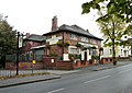
Pubs

Grapes Hotel - geograph.org.uk - 1011513.jpg
Cheshire Cheese - geograph.org.uk - 1011523.jpg
Queen Adelaide - geograph.org.uk - 892352.jpg
Lamb Inn - geograph.org.uk - 1024603.jpg
Pubs of Gee Cross include (clockwise): The Grapes Hotel, The Cheshire Cheese, The Lamb Inn (now closed) and The Queen Adelaide.

The village is a popular social venue, featuring numerous pubs alongside newer restaurants and bars. These include The Buxton, The Queen Adelaide, The Werneth and The Cheshire Cheese.

In 1817, the Cheshire Cheese premises were three private cottages owned by Bristowe Cooper. Behind them was a small dingle called Sugar Loaf Wood and one could walk down a path through this to a plantation which was owned by Samuel Ashton, the cotton magnate. The cottages were later transformed into a school for the children of Gee Cross and Bristowe Cooper became the schoolmaster. Around 1857, the school was closed and the premises became a butcher's shop, a beerhouse and a grocer's shop. The three cottages were then owned by Benjamin Cocker, who was also the first licensee of the beerhouse and who gave it the sign of the Cheshire Cheese. After Benjamin left, Betsy Emery ran the three shops single handedly for many years. The Emery family occupied the "Cheese" until around 1974, the butchers became part of the pub in 1919 and the grocer's shop closed in 1959. It was a freehouse until 1943, when it was bought by Yates Brewery and then it later came under the John Smiths banner. Under new management in 2020, the "Cheese" has once again started to be the heart of the Gee Cross community and the Grapes Hotel. The former Lamb Inn has been converted to a day nursery. Another addition to the already thriving Gee Cross pub scene is the Joshua Bradley. Named after the former Mayor of Hyde and situated on the borders of the village, this 19th-century former private hall (Bamford Hall in its previous incarnation) has been subject to a £3 million transformation by Hydes brewery.[ citation needed ]

Education

Gee Cross contains two primary schools: Dowson Primary [3] and Gee Cross Holy Trinity (CofE). [4] Just outside Gee Cross is Alder Community High School, which is a new secondary school built in 2004. It is a computing and maths specialist school, which teaches over 800 11-16 year olds. [5]

Religion

Hyde Chapel - geograph.org.uk - 1089798.jpg
Holy Trinity - geograph.org.uk - 1075033.jpg
Churches in Gee Cross include Hyde Chapel (left) and Gee Cross Holy Trinity (right).

There are three churches in Gee Cross: an Anglican, Methodist and Unitarian Church. The Unitarian Church in the centre of the village is called Hyde Chapel. [6] The Anglican Church is called Gee Cross Holy Trinity and is affiliated with the primary school. [7] Gee Cross Methodist Church is the other church in the village. [8]

Notable people

Related Research Articles

<span class="mw-page-title-main">Disley</span> Village in Cheshire, England

Disley is a village and civil parish in Cheshire, England. It is located on the edge of the Peak District in the Goyt valley, south of Stockport and close to the county boundary with Derbyshire at New Mills. The population at the 2011 Census was 4,294. To the north, the River Goyt and the Peak Forest Canal, which opened in 1800, pass along the edge of the village. Today, it is a dormitory village retaining a semi-rural character.

<span class="mw-page-title-main">Tameside</span> Borough in Greater Manchester, England

Tameside is a metropolitan borough of Greater Manchester, England, named after the River Tame, which flows through it, and includes the towns of Ashton-under-Lyne, Audenshaw, Denton, Droylsden, Dukinfield, Hyde, Mossley and Stalybridge. Tameside is bordered by the metropolitan boroughs of Stockport to the south, Oldham to the north and northeast, Manchester to the west, and to the east by the Borough of High Peak in Derbyshire. As of 2021, the population of Tameside was 231,199, making it the 8th-most populous borough of Greater Manchester by population.

<span class="mw-page-title-main">Stalybridge</span> Town in Greater Manchester, England

Stalybridge is a town in Tameside, Greater Manchester, England, with a population of 23,731 at the 2011 Census.

<span class="mw-page-title-main">Mottram in Longdendale</span> Human settlement in England

Mottram in Longdendale is a village in Tameside, Greater Manchester, England. At the 2011 census, the population for the ward of Longdendale, which includes Mottram and the surrounding area, was 9,950.

<span class="mw-page-title-main">Denton, Greater Manchester</span> Town in Greater Manchester, England

Denton is a town in Tameside, Greater Manchester, England, five miles (8 km) east of Manchester city centre. Historically part of Lancashire, it had a population of 36,591 at the 2011 Census.

<span class="mw-page-title-main">Stockport</span> Town in Greater Manchester, England

Stockport is an industrial town in Greater Manchester, England, 7 miles (11 km) south-east of Manchester, 9 miles (14 km) south-west of Ashton-under-Lyne and 12 miles (19 km) north of Macclesfield. The River Goyt and Tame merge to create the River Mersey here. It is the main settlement of the wider Metropolitan Borough of Stockport.

<span class="mw-page-title-main">Ashton-under-Lyne</span> Market town in Greater Manchester, England

Ashton-under-Lyne is a market town in Tameside, Greater Manchester, England. The population was 48,604 at the 2021 census. Historically in Lancashire, it is on the north bank of the River Tame, in the foothills of the Pennines, 6 miles (9.7 km) east of Manchester.

<span class="mw-page-title-main">River Tame, Greater Manchester</span> River in Greater Manchester, England

The River Tame flows through Greater Manchester, England. It rises on Denshaw Moor and flows to Stockport where it joins the River Goyt to form the River Mersey.

<span class="mw-page-title-main">Reddish</span> Suburb of Stockport, in Greater Manchester, England

Reddish is an area in Metropolitan Borough of Stockport, Greater Manchester, England. 4.6 miles (7.4 km) south-east of Manchester city centre. At the 2011 census, the population was 28,052. Historically part of Lancashire, Reddish grew rapidly in the Industrial Revolution and still retains landmarks from that period, such as Houldsworth Mill, a former textile mill.

<span class="mw-page-title-main">Dukinfield</span> Town in Greater Manchester, England

Dukinfield is a town in Tameside, Greater Manchester, England, on the south bank of the River Tame opposite Ashton-under-Lyne, 6.3 miles (10.1 km) east of Manchester. At the 2011 Census, it had a population of 19,306.

<span class="mw-page-title-main">Hyde, Greater Manchester</span> Town in Tameside, Greater Manchester, England

Hyde is a town in Tameside, Greater Manchester, England, which had a population of 35,890 in 2021.

<span class="mw-page-title-main">Flowery Field</span> Human settlement in England

Flowery Field is an area of Hyde, Greater Manchester, England.

<span class="mw-page-title-main">Mossley</span> Town in Tameside, Greater Manchester, England

Mossley (/ˈmɒzli/) is a town and civil parish in Tameside, Greater Manchester, England. It is located in the upper Tame Valley and the foothills of the Pennines, 3 miles (4.8 km) south-east of Oldham and 8.9 miles (14.3 km) east of Manchester.

<span class="mw-page-title-main">Werneth Low</span>

Werneth Low is a hill in Greater Manchester, England, and a part of the Pennines. It is located on the borders of Stockport and Tameside, rising to a height of 279 metres (915 ft). The villages of Woodley, Greave, Gee Cross, Mottram and Romiley lie on the sides of the low.

<span class="mw-page-title-main">Woodley, Greater Manchester</span> Human settlement in England

Woodley is a suburb in the Metropolitan Borough of Stockport, Greater Manchester, England. It is situated on the east side of the Peak Forest Canal, next to Bredbury, Romiley and the boundary with Tameside, at Gee Cross.

<span class="mw-page-title-main">Romiley</span> Human settlement in England

Romiley is a village in the Metropolitan Borough of Stockport, Greater Manchester, England. Historically part of Cheshire, it borders Marple, Bredbury and Woodley. At the 2011 census, the Romiley ward, which includes Compstall, Bredbury Green and a large part of Bredbury, had a population of 14,139.

<span class="mw-page-title-main">Mellor, Greater Manchester</span> Human settlement in England

Mellor is a village in Greater Manchester, England, lying between Marple Bridge and New Mills, Derbyshire.

<span class="mw-page-title-main">Ashton-under-Lyne bus station</span> Bus station in Ashton-under-Lyne, Greater Manchester, England

Ashton-under-Lyne bus station is a bus station that is located in the town of Ashton-under-Lyne in Greater Manchester, run by Transport for Greater Manchester. The bus station is situated on Wellington Road and adjoins the Arcades Shopping Centre. The bus station was opened in 2020 and replaced the previous bus station that was built on the current site.

<span class="mw-page-title-main">Grade I listed churches in Greater Manchester</span>

Greater Manchester is a metropolitan county in North West England. It was created by the Local Government Act 1972, and consists of the metropolitan boroughs of Bolton, Bury, Oldham, Rochdale, Stockport, Tameside, Trafford, Wigan and the cities of Manchester and Salford. This is a complete list of the Grade I listed churches in the metropolitan county as recorded in the National Heritage List for England. Buildings are listed by the Secretary of State for Culture, Media and Sport on the recommendation of English Heritage. Grade I listed buildings are defined as being of "exceptional interest, sometimes considered to be internationally important"; only 2.5 per cent of listed buildings are included in this grade.

References

  1. 1 2 "Township Information - Hyde". www.tameside.gov.uk.
  2. author, Audi. "Audi Approved Hyde". Audi UK.{{cite web}}: |last= has generic name (help)
  3. "Dowson Primary Academy". www.dowson.tameside.sch.uk.
  4. "Gee Cross Holy Trinity Church of England (VC) Primary and Nursery School - Home". www.geecross.tameside.sch.uk.
  5. "Alder Community High School". www.aldercommunityhighschool.org.uk.
  6. "Hyde Chapel – Gee Cross".
  7. "HOME". HolyTrinityGx.
  8. "Gee Cross Methodist Church". Archived from the original on 13 January 2012.
  9. https://www.waiyin.org.uk/2017/07/cycling-social-inclusion/
  10. Wisden Cricket Monthly. "Nigel Howard player profile". Cricinfo.com. Retrieved 28 August 2007.