Geithain

Last updated
Geithain
Geithain Nikolaikirche Stadttor.jpg
Saint Nicholas Church
Wappen Geithain.svg
Location of Geithain within Leipzig district
Geithain in L.svgBornaBrandis
Germany adm location map.svg
Red pog.svg
Geithain
Saxony location map.svg
Red pog.svg
Geithain
Coordinates: 51°3′N12°41′E / 51.050°N 12.683°E / 51.050; 12.683 Coordinates: 51°3′N12°41′E / 51.050°N 12.683°E / 51.050; 12.683
Country Germany
State Saxony
District Leipzig
Subdivisions10
Government
   Mayor (202229) Frank Rudolph [1]
Area
  Total54.71 km2 (21.12 sq mi)
Elevation
225 m (738 ft)
Population
 (2021-12-31) [2]
  Total6,775
  Density120/km2 (320/sq mi)
Time zone UTC+01:00 (CET)
  Summer (DST) UTC+02:00 (CEST)
Postal codes
04643
Dialling codes 034341
Vehicle registration L, BNA, GHA, GRM, MTL, WUR
Website www.geithain.de

Geithain is a town in the Leipzig district, in Saxony, Germany.

Contents

Geography

Geithain is 30 km (19 mi) northwest of Chemnitz and 40 km (25 mi) southeast of Leipzig. It lies in hilly country by the wooded area Wickershain and the river Eula.

History

The first documented mention of the town was in the year 1186 in a document, which described the donation of earnings from the Wickershainer Marion Church to the Bishop of Merseburg through the Duke Dedo III (Lausitz).

The name of the town has its origins in the Old Sorbian word "Chytan" (Chyten) and describes the place of Chyten, where "Chyt" (Chit) is a Sorbian first name.

In 1209 there was another documented mention of Geithain and the already established Nicolai Church. In this year the establishment of a hospital and a chapel (of St. James) was ordered by Duke Dedo III (1190–1210), the Margrave of Lausitz. Also, although Geithain is described as a town in this document, a charter with the first mayor (Hermanus Hongil [3] ) is first evident for the year 1335. From 1346 cisterns and wooden water conduits were constructed in Geithain, which were used until 1904.

Geithain was administered in the Middle Ages by a Vogt, who had his seat in the Freihof, first mentioned in 1349. The Geithain powder-tower, today one of the sights of the town, was part of the Freihof and was inserted with this into the town's fortifications.

1936 was the 750th anniversary of Geithain. They had a celebration for 3 days around 1 September.

In World War II the town had 219 dead. On 13 April 1945 alone 13 people were killed in a single air raid on the town. The target of the low-flying aircraft was the railway station. On 14 April the Second World War ended for Geithain with the arrival of American troops.

As of 1 July 2017 Narsdorf has been incorporated into Geithain together with its parts Bruchheim, Dölitzsch, Kolka, Narsdorf, Niederpickenhain, Oberpickenhain, Ossa, Rathendorf, and Wenigossa [4]

Transport

Geithain is located on Neukieritzsch–Chemnitz and Leipzig–Geithain railway lines, which connect at Geithain station.

In 2013 another section of federal motorway A 72 was opened, also connecting Geithain with exit no 23 and via B 7.

Notable people

Related Research Articles

<span class="mw-page-title-main">Strehla</span> Town in Saxony, Germany

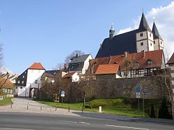
Strehla is a small town in the district of Meißen, Saxony, Germany. It is located on the river Elbe, north of Riesa. This place name means arrow in Sorbian. Strehla includes the following subdivisions:

<span class="mw-page-title-main">Döbeln</span> Town in Saxony, Germany

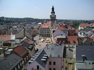
Döbeln is a town in Saxony, Germany, part of the Mittelsachsen district, on both banks of the river Freiberger Mulde.

<span class="mw-page-title-main">Bad Muskau</span> Town in Saxony, Germany

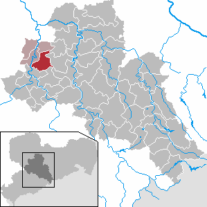
Bad Muskau is a spa town in the historic Upper Lusatia region in Germany, at the border with Poland. It is part of the Görlitz district in the State of Saxony.

<span class="mw-page-title-main">Hochkirch</span> Municipality in Saxony, Germany

Hochkirch (German) or Bukecy is a municipality in the district of Bautzen, in Saxony, Germany. It is known for the 1758 Battle of Hochkirch, part of the Seven Years' War.

<span class="mw-page-title-main">Grimma</span> Town in Saxony, Germany

Grimma is a town in Saxony, Central Germany, on the left bank of the Mulde, 25 kilometres (16 mi) southeast of Leipzig. Founded in c. 1170, it is part of the Leipzig district.

<span class="mw-page-title-main">Oschatz</span> Municipality in Saxony, Germany

Oschatz is a town in the district Nordsachsen, in Saxony, Germany. It is located 60 km east of Leipzig and 60 km west of Dresden.

<span class="mw-page-title-main">Borna, Leipzig</span> Town in Saxony, Germany

Borna is a town in Saxony, Germany, capital of the Leipzig district. It is situated approximately 30 km southeast of Leipzig city. It has approx. 19,000 inhabitants. The town is the district seat of the district of Leipzig.

<span class="mw-page-title-main">Rochlitz</span> Town in Saxony, Germany

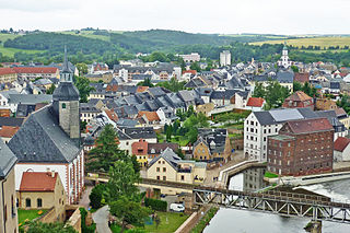
Rochlitz is a major district town in the district of Mittelsachsen, in Saxony, Germany. Rochlitz is the head of the "municipal partnership Rochlitz" with its other members being the municipalities of Königsfeld, Seelitz and Zettlitz.

<span class="mw-page-title-main">Bad Lausick</span> Town in Saxony, Germany

Bad Lausick is a town in the Leipzig district, in Saxony, Germany. It is situated 12 km southwest of Grimma, and 29 km southeast of Leipzig.

<span class="mw-page-title-main">Frohburg</span> Town in Saxony, Germany

Frohburg is a town in the Leipzig district, in Saxony, Germany. It is situated 11 km northeast of Altenburg, and 34 km southeast of Leipzig. It includes the village of Flößberg and the town Kohren-Sahlis.

<span class="mw-page-title-main">Groitzsch</span> Town in Saxony, Germany

Groitzsch is a town in the Leipzig district, in Saxony, Germany.

<span class="mw-page-title-main">Königsbrück</span> Town in Saxony, Germany

Königsbrück is a town in the Bautzen district, in Saxony, Germany. It is situated 14 km (8.7 mi) west of Kamenz, and 27 km (17 mi) northeast of the Saxon capital Dresden. Königsbrück is known as the western gate of the historic Upper Lusatia region.

<span class="mw-page-title-main">Oederan</span> Town in Saxony, Germany

Oederan is a town in the district of Mittelsachsen, in Saxony, Germany.

<span class="mw-page-title-main">Sebnitz</span> Town in Saxony, Germany

Sebnitz is a town in the Sächsische Schweiz-Osterzgebirge district, in Saxony, Germany.

<span class="mw-page-title-main">Neukirch/Lausitz</span> Town in Saxony, Germany

Neukirch/Lausitz (German) or Wjazońca is a municipality in Upper Lusatia in the district of Bautzen, in the state of Saxony in eastern Germany. It belongs to the district of Bautzen and is situated in several valleys of the mountain region Lausitzer Bergland, near the hill "Valtenberg" that reaches about 587 metres. It has about 5,066 inhabitants in an area of 21.32 km², a population density of 240 per km². The German name Lausitz means Lusatia.

<span class="mw-page-title-main">Belgershain</span> Municipality in Saxony, Germany

Belgershain is a town in the Leipzig district in Saxony. It is part of the municipal association of Naunhof.

<span class="mw-page-title-main">Nebelschütz</span> Municipality in Saxony, Germany

Nebelschütz (German) or Njebjelčicy is a Sorbian village in the district of Bautzen of Saxony in south-east Germany. It lies to the south-east of Kamenz.

<span class="mw-page-title-main">Neukieritzsch</span> Municipality in Saxony, Germany

Neukieritzsch is a municipality in the Leipzig district, in Saxony, Germany. On 1 April 2008, the former municipality of Lobstädt was incorporated into Neukieritzsch. On 1 July 2014, the former municipality of Deutzen was incorporated into Neukieritzsch.

<span class="mw-page-title-main">Seelitz</span> Municipality in Saxony, Germany

Seelitz is a municipality in the district of Mittelsachsen, in Saxony, Germany. It is part of the administrative partnership Verwaltungsgemeinschaft Rochlitz based in the eponymous town.

<span class="mw-page-title-main">Otterwisch</span> Municipality in Saxony, Germany

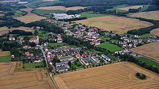
Otterwisch is a municipality in the Leipzig district in Saxony, Germany.

References

  1. Gewählte Bürgermeisterinnen und Bürgermeister im Freistaat Sachsen, Stand: 17. Juli 2022, Statistisches Landesamt des Freistaates Sachsen.
  2. "Bevölkerung des Freistaates Sachsen nach Gemeinden am 31. Dezember 2021" (XLS) (in German). Statistisches Landesamt des Freistaates Sachsen. 2022.
  3. https://ul.qucosa.de/api/qucosa%3A12858/attachment/ATT-0/
  4. "Eingemeindung Narsdorf". Stadt Geithein. Retrieved 24 July 2017.