Geographic routing

Last updated

Geographic routing (also called georouting [1] or position-based routing) is a routing principle that relies on geographic position information. It is mainly proposed for wireless networks and based on the idea that the source sends a message to the geographic location of the destination instead of using the network address. In the area of packet radio networks, the idea of using position information for routing was first proposed in the 1980s [2] for interconnection networks. [3] Geographic routing requires that each node can determine its own location and that the source is aware of the location of the destination. With this information, a message can be routed to the destination without knowledge of the network topology or a prior route discovery.

Contents

Approaches

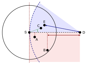
There are various approaches, such as single-path, multi-path and flooding-based strategies (see [4] for a survey). Most single-path strategies rely on two techniques: greedy forwarding and face routing. Greedy forwarding tries to bring the message closer to the destination in each step using only local information. Thus, each node forwards the message to the neighbor that is most suitable from a local point of view. The most suitable neighbor can be the one who minimizes the distance to the destination in each step (Greedy). Alternatively, one can consider another notion of progress, namely the projected distance on the source-destination-line (MFR, NFP), or the minimum angle between neighbor and destination (Compass Routing). Not all of these strategies are loop-free, i.e. a message can circulate among nodes in a certain constellation. It is known that the basic greedy strategy and MFR are loop free, while NFP and Compass Routing are not. [5]

Georouting greedy variants.svg
Greedy forwarding variants: The source node (S) has different choices to find a relay node for further forwarding a message to the destination (D). A = Nearest with Forwarding Progress (NFP), B = Most Forwarding progress within Radius (MFR), C = Compass Routing, E = Greedy
Georouting face routing.svg
Face routing: A message is routed along the interior of the faces of the communication graph, with face changes at the edges crossing the S-D-line (red). The final routing path is shown in blue.

Greedy forwarding can lead into a dead end, where there is no neighbor closer to the destination. Then, face routing helps to recover from that situation and find a path to another node, where greedy forwarding can be resumed. A recovery strategy such as face routing is necessary to assure that a message can be delivered to the destination. The combination of greedy forwarding and face routing was first proposed in 1999 under the name GFG (Greedy-Face-Greedy). [6] It guarantees delivery in the so-called unit disk graph network model. Various variants, which were proposed later [7] , also for non-unit disk graphs, are based on the principles of GFG . [1]

Face routing depends on a planar subgraph in general; however distributed planarization is difficult for real wireless sensor networks and does not scale well to 3D environments. [8]

Greedy embedding

Although originally developed as a routing scheme that uses the physical positions of each node, geographic routing algorithms have also been applied to networks in which each node is associated with a point in a virtual space, unrelated to its physical position. The process of finding a set of virtual positions for the nodes of a network such that geographic routing using these positions is guaranteed to succeed is called greedy embedding. [9]

See also

Related Research Articles

Routing is the process of selecting a path for traffic in a network or between or across multiple networks. Broadly, routing is performed in many types of networks, including circuit-switched networks, such as the public switched telephone network (PSTN), and computer networks, such as the Internet.

Link-state routing protocols are one of the two main classes of routing protocols used in packet switching networks for computer communications, the others being distance-vector routing protocols. Examples of link-state routing protocols include Open Shortest Path First (OSPF) and Intermediate System to Intermediate System (IS-IS).

<span class="mw-page-title-main">Distributed hash table</span> Decentralized distributed system with lookup service

A distributed hash table (DHT) is a distributed system that provides a lookup service similar to a hash table. Key–value pairs are stored in a DHT, and any participating node can efficiently retrieve the value associated with a given key. The main advantage of a DHT is that nodes can be added or removed with minimum work around re-distributing keys. Keys are unique identifiers which map to particular values, which in turn can be anything from addresses, to documents, to arbitrary data. Responsibility for maintaining the mapping from keys to values is distributed among the nodes, in such a way that a change in the set of participants causes a minimal amount of disruption. This allows a DHT to scale to extremely large numbers of nodes and to handle continual node arrivals, departures, and failures.

<span class="mw-page-title-main">Wireless mesh network</span> Radio nodes organized in a mesh topology

A wireless mesh network (WMN) is a communications network made up of radio nodes organized in a mesh topology. It can also be a form of wireless ad hoc network.

<span class="mw-page-title-main">Mesh networking</span> Network with multiple links between nodes

A mesh network is a local area network topology in which the infrastructure nodes connect directly, dynamically and non-hierarchically to as many other nodes as possible and cooperate with one another to efficiently route data to and from clients.

<span class="mw-page-title-main">Optimized Link State Routing Protocol</span> IP routing protocol optimized for mobile ad hoc networks

The Optimized Link State Routing Protocol (OLSR) is an IP routing protocol optimized for mobile ad hoc networks, which can also be used on other wireless ad hoc networks. OLSR is a proactive link-state routing protocol, which uses hello and topology control (TC) messages to discover and then disseminate link state information throughout the mobile ad hoc network. Individual nodes use this topology information to compute next hop destinations for all nodes in the network using shortest hop forwarding paths.

Wireless sensor networks (WSNs) refer to networks of spatially dispersed and dedicated sensors that monitor and record the physical conditions of the environment and forward the collected data to a central location. WSNs can measure environmental conditions such as temperature, sound, pollution levels, humidity and wind.

Dynamic Source Routing (DSR) is a routing protocol for wireless mesh networks. It is similar to AODV in that it forms a route on-demand when a transmitting node requests one. However, it uses source routing instead of relying on the routing table at each intermediate device.

Delay-tolerant networking (DTN) is an approach to computer network architecture that seeks to address the technical issues in heterogeneous networks that may lack continuous network connectivity. Examples of such networks are those operating in mobile or extreme terrestrial environments, or planned networks in space.

In computer networking, linear network coding is a program in which intermediate nodes transmit data from source nodes to sink nodes by means of linear combinations.

<span class="mw-page-title-main">Flooding (computer networking)</span> Simple routing algorithm sending incoming packets to all other links than the sender

Flooding is used in computer networks routing algorithm in which every incoming packet is sent through every outgoing link except the one it arrived on.

A wireless ad hoc network (WANET) or mobile ad hoc network (MANET) is a decentralized type of wireless network. The network is ad hoc because it does not rely on a pre-existing infrastructure, such as routers or wireless access points. Instead, each node participates in routing by forwarding data for other nodes. The determination of which nodes forward data is made dynamically on the basis of network connectivity and the routing algorithm in use.

<span class="mw-page-title-main">B.A.T.M.A.N.</span> Routing protocol for multi-hop mobile ad hoc networks

The Better Approach to Mobile Ad-hoc Networking (B.A.T.M.A.N.) is a routing protocol for multi-hop mobile ad hoc networks which is under development by the German "Freifunk" community and intended to replace the Optimized Link State Routing Protocol (OLSR).

Extremely Opportunistic Routing (ExOR) is a combination of routing protocol and media access control for a wireless ad hoc network, invented by Sanjit Biswas and Robert Morris of the MIT Artificial Intelligence Laboratory, and described in a 2005 paper. A very similar opportunistic routing scheme was also independently proposed by Zhenzhen Ye and Yingbo Hua from University of California, Riverside and presented in a paper in 2005. Previously open source, ExOR was available in 2005 but is no longer obtainable. The broadcast and retransmission strategies used by the algorithm were already described in the literature. ExOR is valuable because it can operate available digital radios to use some previously impractical algorithmic optimizations.

Routing in delay-tolerant networking concerns itself with the ability to transport, or route, data from a source to a destination, which is a fundamental ability all communication networks must have. Delay- and disruption-tolerant networks (DTNs) are characterized by their lack of connectivity, resulting in a lack of instantaneous end-to-end paths. In these challenging environments, popular ad hoc routing protocols such as AODV and DSR fail to establish routes. This is due to these protocols trying to first establish a complete route and then, after the route has been established, forward the actual data. However, when instantaneous end-to-end paths are difficult or impossible to establish, routing protocols must take to a "store and forward" approach, where data is incrementally moved and stored throughout the network in hopes that it will eventually reach its destination. A common technique used to maximize the probability of a message being successfully transferred is to replicate many copies of the message in hopes that one will succeed in reaching its destination.

Scalable Source Routing (SSR) is a routing protocol for unstructured networks such as mobile ad hoc networks, mesh networks, or sensor networks. It combines source routing with routing along a virtual ring, and is based on the idea of "pushing Chord into the underlay".

A mobile wireless sensor network (MWSN) can simply be defined as a wireless sensor network (WSN) in which the sensor nodes are mobile. MWSNs are a smaller, emerging field of research in contrast to their well-established predecessor. MWSNs are much more versatile than static sensor networks as they can be deployed in any scenario and cope with rapid topology changes. However, many of their applications are similar, such as environment monitoring or surveillance. Commonly, the nodes consist of a radio transceiver and a microcontroller powered by a battery, as well as some kind of sensor for detecting light, heat, humidity, temperature, etc.

In distributed computing and geometric graph theory, greedy embedding is a process of assigning coordinates to the nodes of a telecommunications network in order to allow greedy geographic routing to be used to route messages within the network. Although greedy embedding has been proposed for use in wireless sensor networks, in which the nodes already have positions in physical space, these existing positions may differ from the positions given to them by greedy embedding, which may in some cases be points in a virtual space of a higher dimension, or in a non-Euclidean geometry. In this sense, greedy embedding may be viewed as a form of graph drawing, in which an abstract graph is embedded into a geometric space.

Opportunistic mobile social networks are a form of mobile ad hoc networks that exploit the human social characteristics, such as similarities, daily routines, mobility patterns, and interests to perform the message routing and data sharing. In such networks, the users with mobile devices are able to form on-the-fly social networks to communicate with each other and share data objects.

References

  1. 1 2 Ruehrup, Stefan (2009). Liu; Chu; Leung (eds.). Theory and Practice of Geographic Routing (PDF). Ad Hoc and Sensor Wireless Networks: Architectures, Algorithms and Protocols. Bentham Science.
  2. Takagi, H.; Kleinrock, L. (March 1984). "Optimal transmission ranges for randomly distributed packet radio terminals". IEEE Transactions on Communications. 32 (3): 246–257. CiteSeerX   10.1.1.64.9747 . doi:10.1109/TCOM.1984.1096061.
  3. Finn, Gregory G. (March 1987). "Routing and Addressing Problems in Large Metropolitan-Scale Internetworks" (PDF). University of Southern California, ISI/RR-87-180.
  4. Stojmenovic, Ivan (2002). "Position based routing in ad hoc networks". IEEE Communications Magazine. 40 (7): 128–134. CiteSeerX   10.1.1.6.6012 . doi:10.1109/MCOM.2002.1018018.
  5. Stojmenovic, Ivan; Lin, Xu (2001). "Loop-free hybrid single-path/flooding routing algorithms with guaranteed delivery for wireless networks". IEEE Transactions on Parallel and Distributed Systems. 12 (10): 1023–1032. CiteSeerX   10.1.1.67.7527 . doi:10.1109/71.963415.
  6. Bose, P.; Morin, P.; Stojmenovic, I.; Urrutia, J. (1999). "Routing with guaranteed delivery in ad hoc wireless networks". Proc. of the 3rd international workshop on discrete algorithms and methods for mobile computing and communications (DIALM '99). pp. 48–55. doi: 10.1145/313239.313282 .
  7. Djenouri, Djamel; Balasingham, Ilangko (2011). "Traffic-Differentiation-Based Modular QoS Localized Routing for Wireless Sensor Networks". IEEE Transactions on Mobile Computing. 10 (6): 797–809. doi:10.1109/TMC.2010.212. S2CID   11139687.
  8. Kim, Y; Ramesh Govindan; Karp, Brad.; Scott Shenker (2005). "On the Pitfalls of Geographic Face Routing". Proceedings of the 2005 Joint Workshop on Foundations of Mobile Computing. pp. 34–43. doi:10.1145/1080810.1080818.
  9. Rao, Ananth; Ratnasamy, Sylvia; Papadimitriou, Christos H.; Shenker, Scott; Stoica, Ion (2003), "Geographic routing without location information", Proc. 9th ACM Mobile Computing and Networking (MobiCom), pp. 96–108.