Geography of Shanghai

Last updated
Geography of Shanghai
Shanghai Landsat-7 2005-08-15.jpg
Continent Asia
Location Yangtze River Delta
Coordinates 31°12′N121°30′E / 31.200°N 121.500°E / 31.200; 121.500
AreaTotal: 6,340 km2 (2,450 sq mi)
- Land: 6,218 km2 (2,401 sq mi)
- Water: 121 km2 (47 sq mi)
Average elevation4 m (13 ft) above sea level

The geography of Shanghai is characterised by its location on the Yangtze River Delta on China's east coast and its proximity to the Pacific Ocean via the East China Sea. The city is centred on the Huangpu River, a tributary of the Yangtze River, and extends outwards in all directions, with the suburbs and satellite towns reaching east to the East China Sea, north and west to Jiangsu province, and south to Zhejiang province over Hangzhou Bay.

Contents

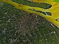
The vast majority of Shanghai's land area is flat, apart from a few hills in the southwest corner, due to its location on the alluvial plain of the Yangtze's river delta. The city has many rivers and lakes and is known for its rich water resources, and thanks to its coastal, riverside location and warm climate ensuring ice-free waters, provides easy access to China's interior, resulting in Shanghai being the world's largest port. [1]

Statistics

Location

Shanghai is located in the middle of China's east coast, near the mouth of the Yangtze River, being one of the core cities in the Yangtze River Delta region and one of the coastal cities in China. It is bordered by the Yangtze River to the north, the East China Sea to the east, Hangzhou Bay to the south, and Jiangsu and Zhejiang Provinces to the west. The city is roughly equidistant to Beijing and Hong Kong, and is located at 31°12′N121°30′E / 31.200°N 121.500°E / 31.200; 121.500 , roughly the same latitude as San Diego, New Orleans, Bermuda, Marrakech, Cairo, Jerusalem, and Lahore. Cities within mainland China that lie on approximately the same longitude include Fuxin, Jinzhou, Dalian, Yantai, Ningbo, and Taizhou (Zhejiang). The municipality lies about due north of Taipei and Manila.

Area

Waterways

Shanghai contains 53.1 km (33.0 mi) of rivers and streams and is part of the Lake Tai drainage area. Suzhou Creek is 125 km (78 mi) long and has an average width of 70 to 80 meters, while the Huangpu River is 80 km (50 mi) long and is around 400 meters wide. [2]

Shanghai's development of the deep-water port of Yangshan in Zhejiang was made necessary by the increasing size of container ships but also the silting of the Yangtze, which narrows to less than 20 meters (66 ft) as far out as 45 miles (70 km) from Hengsha. [3]

Islands

The Municipality of Shanghai administers a number of islands around its peninsula, including most of Chongming Island (1,267 km2 or 489 sq mi), the second-largest island of mainland China. Chongming, Changxing (88.54 km2 or 34.19 sq mi), and Hengsha (55.74 km2 or 21.52 sq mi) comprise the permanently inhabited islands of Shanghai, while the city's 19 uninhabited islands covered 226.27 km2 (87.36 sq mi) in 2006, with a total coastline of 309 kilometers (192 mi). [4]

Most of Shanghai's islands are small alluvial islands ( ) created by the natural deposition of vast amounts of silt by the Yangtze River. The major islands ( ) of Chongming, Changxing, and Hengsha in Chongming County were formed in this way, as were the shoals of Jiuduansha (114.6 km2 or 44.2 sq mi) off of Pudong. The natural expansion of these islands has been greatly accelerated by reclamation projects, with Chongming more than doubling in size between 1950 and 2010. [5] Unlike the islands of Chongming County, Jiuduansha was expanded and protected as an uninhabited nature reserve [6] to make up for the wetlands destroyed by the creation of Pudong International Airport. [7] It is an important spawning ground for Shanghai's hairy crab community, [8] as well as other maritime [8] [9] [10] and avian species. [11] A few islands in Hangzhou Bay off Jinshan District are rocky islands (also ). Dajinshan, Xiaojinshan, and Fushan are municipal nature reserves. [4] The peak of Dajinshan is the highest point in the Municipality of Shanghai, with altitude of 103.4 meters (339 ft).

Shanghai does not administer the islands of Greater and Lesser Yangshan, the site of the Port of Shanghai's Yangshan Deep-Water Port. Instead, the belong to Zhejiang Province, despite being linked via the Donghai Bridge to Pudong. Similarly, Chongming's absorption of Jiangsu's Yonglongsha shoal produced a long but narrow exclave of that province on its northern shore.

Climate

Shanghai
Climate chart (explanation)
J
F
M
A
M
J
J
A
S
O
N
D
 
 
74
 
 
8
2
 
 
59
 
 
10
4
 
 
94
 
 
14
7
 
 
74
 
 
20
12
 
 
85
 
 
25
17
 
 
182
 
 
28
22
 
 
146
 
 
32
26
 
 
214
 
 
32
26
 
 
87
 
 
28
22
 
 
56
 
 
23
17
 
 
52
 
 
17
11
 
 
44
 
 
11
5
Average max. and min. temperatures in °C
Precipitation totals in mm
Source: CMA
Imperial conversion
JFMAMJJASOND
 
 
2.9
 
 
47
36
 
 
2.3
 
 
50
39
 
 
3.7
 
 
57
44
 
 
2.9
 
 
67
53
 
 
3.3
 
 
77
63
 
 
7.2
 
 
82
71
 
 
5.7
 
 
90
78
 
 
8.4
 
 
89
78
 
 
3.4
 
 
82
72
 
 
2.2
 
 
73
62
 
 
2.1
 
 
63
51
 
 
1.7
 
 
52
40
Average max. and min. temperatures in °F
Precipitation totals in inches
A rare snowfall in Shanghai 2008 Shanghai Snow.jpg
A rare snowfall in Shanghai
The Bund and the skyline behind it during a rainy evening Shanghai night skyline.jpg
The Bund and the skyline behind it during a rainy evening

Shanghai has a humid subtropical climate (Köppen climate classification Cfa) and experiences four distinct seasons. In winter, cold northerly winds from Siberia can cause nighttime temperatures to drop below freezing, and although not usually associated with snow, the city can receive one or two days of snowfall per year. In contrast, and in spite of being the peak tourist season, summer in Shanghai is very warm and humid, with occasional downpours or freak thunderstorms. The city is also susceptible to typhoons, none of which in recent years has caused considerable damage. [12] The most pleasant seasons are Spring, although changeable, and Autumn, which is generally sunny and dry.

Climate statistics of 2013: [13]

Climate data for Shanghai (Pudong) (normals 1991–2020, extremes 1951–present)
MonthJanFebMarAprMayJunJulAugSepOctNovDecYear
Record high °C (°F)22.1
(71.8)
27.0
(80.6)
29.6
(85.3)
34.3
(93.7)
36.4
(97.5)
37.5
(99.5)
40.9
(105.6)
39.9
(103.8)
38.2
(100.8)
36.0
(96.8)
28.7
(83.7)
23.4
(74.1)
40.9
(105.6)
Average high °C (°F)8.9
(48.0)
10.7
(51.3)
15.1
(59.2)
20.7
(69.3)
25.4
(77.7)
28.0
(82.4)
32.8
(91.0)
32.3
(90.1)
28.4
(83.1)
23.6
(74.5)
18.1
(64.6)
11.6
(52.9)
21.3
(70.3)
Daily mean °C (°F)5.1
(41.2)
6.7
(44.1)
10.6
(51.1)
15.9
(60.6)
20.9
(69.6)
24.2
(75.6)
28.7
(83.7)
28.5
(83.3)
24.7
(76.5)
19.7
(67.5)
13.9
(57.0)
7.6
(45.7)
17.2
(63.0)
Average low °C (°F)2.1
(35.8)
3.4
(38.1)
6.9
(44.4)
11.8
(53.2)
17.1
(62.8)
21.2
(70.2)
25.5
(77.9)
25.6
(78.1)
21.7
(71.1)
16.2
(61.2)
10.4
(50.7)
4.3
(39.7)
13.9
(56.9)
Record low °C (°F)−10.1
(13.8)
−7.9
(17.8)
−5.4
(22.3)
−0.5
(31.1)
6.9
(44.4)
12.3
(54.1)
16.3
(61.3)
18.8
(65.8)
10.8
(51.4)
1.7
(35.1)
−4.2
(24.4)
−8.5
(16.7)
−10.1
(13.8)
Average precipitation mm (inches)77.2
(3.04)
69.8
(2.75)
85.1
(3.35)
87.1
(3.43)
91.1
(3.59)
231.1
(9.10)
154.2
(6.07)
227.0
(8.94)
136.3
(5.37)
78.1
(3.07)
70.4
(2.77)
57.1
(2.25)
1,364.5
(53.72)
Average precipitation days (≥ 0.1 mm)10.610.812.211.011.314.412.213.310.77.59.79.0132.7
Average relative humidity (%)73747271748278797773757175
Mean monthly sunshine hours 107.1111.1147.0168.4173.1120.0189.8191.4156.8152.3122.7123.41,763.1
Percent possible sunshine 33353943412844474344394040
Source: China Meteorological Administration [14] [15]

Cityscape

Shanghai city proper is bisected by the Huangpu River: Puxi, on the west side, is the historic center of the city, and includes the districts of Yangpu, Hongkou, Putuo, Changning, Xuhui, Jing'an, and Huangpu. Pudong is located on the east side and is the location of Shanghai's rapid development, including its new famous skyline and the Lujiazui financial district.

The outer districts, or suburbs, surround the city proper, and are Baoshan, Minhang, Jiading, Jinshan, Songjiang, Qingpu, Fengxian, and the rural eastern and southern part of Pudong.

Chongming is Shanghai's only current county and lies north of the Shanghai Peninsula on three inhabited islands in the Yangtze estuary: Chongming, Changxing, and Hengsha. Historical counties have included Nanhui and Chuansha.

Environment

Xintiandi, a pedestrian-only area of Shanghai Shanghai-Xintandi.jpg
Xintiandi, a pedestrian-only area of Shanghai

Public awareness of the environment is growing, and the city is investing in a number of environmental protection projects. A 10-year, US$1 billion cleanup of Suzhou Creek, which runs through the city center, is expected to be finished in 2008, [16] and the government also provides incentives for transportation companies to invest in LPG buses and taxis. Air pollution in Shanghai is low compared to other Chinese cities such as Beijing, but the rapid development over the past decades means it is still high on worldwide standards, comparable to Los Angeles. [17]

Maps and satellite images

See also

Related Research Articles

<span class="mw-page-title-main">Chongming District</span> District in Shanghai, Peoples Republic of China

Chongming District is northernmost district of the provincial-level municipality of Shanghai. Chongming consists of three low-lying inhabited alluvial islands at the mouth of the Yangtze north of the Shanghai peninsula: Chongming, Changxing, and Hengsha. Following its massive expansion in the 20th century, Chongming is now the 2nd-largest island administered by the People's Republic of China and the 2nd-largest in Greater China, after Hainan. Chongming does not, however, administer all of the island: owing to its continual expansion from sediment deposited by the Yangtze, it has merged with formerly separate islands and now includes Jiangsu province's pene-exclave townships of Haiyong and Qilong. Chongming proper covers an area of 1,411 km2 (545 sq mi) and had a population of 704 000 at the time of the Sixth National Census in 2010.

<span class="mw-page-title-main">Pudong</span> District in Shanghai, Peoples Republic of China

Pudong is a district of Shanghai located east of the Huangpu, the river which flows through central Shanghai. The name Pudong was originally applied to the Huangpu's east bank, directly across from the west bank or Puxi, the historic city center. It now refers to the broader Pudong New Area, a state-level new area which extends all the way to the East China Sea.

<span class="mw-page-title-main">Taicang</span> County-level city in Jiangsu, Peoples Republic of China

Taicang is a county-level city under the jurisdiction of Suzhou, Jiangsu province, China. The city located in the south of the Yangtze River estuary opposite Nantong, being bordered by Shanghai proper to the south, while the river also delineates much of its northeastern boundary along Chongming Island.

<span class="mw-page-title-main">Nanhui District</span> Former district of Shanghai, China (2001–2009)

Nanhui District, formerly romanized as Nanhwei, was a district of Shanghai until it was merged into Pudong New Area in May 2009. It had a land area of about 809.5 km2 (312.5 sq mi) and a 59.5 km (37.0 mi) coastline. The population of Nanhui was 975,017 as of August 2006. On May 6, 2009, it was announced that the State Council of China had approved the proposal to merge Nanhui District into Pudong, which is also a district of Shanghai.

<span class="mw-page-title-main">Songjiang District</span> District in Shanghai, Peoples Republic of China

Songjiang is a suburban district of Shanghai. It has a land area of 605.64 km2 (233.84 sq mi) and a population of 1,582,398 (2010). Owing to a long history, Songjiang is known as the cultural root of Shanghai.

<span class="mw-page-title-main">Nantong</span> Prefecture-level city in Jiangsu, Peoples Republic of China

Nantong is a prefecture-level city in southeastern Jiangsu province, China. Located on the northern bank of the Yangtze River, near the river mouth. Nantong is a vital river port bordering Yancheng to the north; Taizhou to the west; Suzhou, Wuxi and Shanghai to the south across the river; and the East China Sea to the east. Its population was 7,726,635 as of the 2020 census, 3,766,534 of whom lived in the built-up area made up of three urban districts.

<span class="mw-page-title-main">Chongming Island</span> Northernmost part of Shanghai

Chongming, formerly known as Chungming, is an alluvial island at the mouth of the Yangtze River in eastern China covering 1,267 square kilometers (489 sq mi) as of 2010. Together with the islands Changxing and Hengsha, it forms Chongming District, the northernmost area of the provincial-level municipality of Shanghai. At the time of the 2010 Chinese census, its population was 660,000.

<span class="mw-page-title-main">Qidong, Jiangsu</span> County-level city in Jiangsu, Peoples Republic of China

Qidong is a county-level city under the administration of the prefecture-level city of Nantong in southeastern Jiangsu province, China. It is located on the north side of the Yangtze River opposite Shanghai and forms a peninsula jutting out into the East China Sea. It has a population of 1.12 million.

<span class="mw-page-title-main">Expressways of Shanghai</span> Overview of transport in Shanghai

Shanghai has an expansive grade-separated highway and expressway network consisting of 16 municipal express roads, 10 provincial-level expressways, and 8 national-level expressways. Three municipal expressways and four provincial-level expressways are also under construction.

<span class="mw-page-title-main">Cixi, Zhejiang</span> County-level city in Zhejiang, Peoples Republic of China

Cixi, alternately romanized as Tzeki, is a county-level city under the jurisdiction of the sub-provincial city of Ningbo, in the north of Zhejiang province, China. As of the 2020 census, its population was 1,829,488. Its urban agglomeration built-up area, largely contiguous with Cixi plus the county-level city of Yuyao, had 3,083,520 inhabitants.

<span class="mw-page-title-main">Port of Shanghai</span> Port in China

The Port of Shanghai, located in the vicinity of Shanghai, comprises a deep-sea port and a river port.

<span class="mw-page-title-main">Shanghai Yangtze River Tunnel and Bridge</span> Fixed link between Chongming Island and Pudong, eastern China

The Shanghai Yangtze River Tunnel and Bridge is a bridge–tunnel complex across the south fork of the Yangtze River near the river mouth in Shanghai. The tunnel connects the Pudong District of Shanghai on the south bank of the river with Changxing Island, while the bridge connects Changxing Island with Chongming Island. In combination with the Chongqi Bridge, which connects Chongming Island to the north bank of the Yangtze, the bridge–tunnel complex forms the final crossing of the Yangtze before it empties into the East China Sea.

<span class="mw-page-title-main">Suzhou Creek</span> River in Shanghai, China

Suzhou Creek, also called the Wusong (Woosung) River, is a river that passes through the Shanghai city center. It is named after the neighboring city of Suzhou (Soochow), Jiangsu, the predominant settlement in this area prior to the rise of Shanghai as a metropolis.

<span class="mw-page-title-main">Islands of Shanghai</span> Geographic features in China

The islands of Shanghai are those under the jurisdiction of the Shanghai municipal government. They comprise three large inhabited islands and a shifting number of smaller, uninhabited ones. Most are alluvial islands in the Yangtze River Delta in China, although a number of islands in Hangzhou Bay off Jinshan District are also administered by Shanghai. The alluvial islands are relatively young and their number varies over time. In 2006, the city's 19 uninhabited islands covered 226.27 square kilometers (87.36 sq mi), with a total coastline length of 309 kilometers (192 mi).

<span class="mw-page-title-main">Hengsha Island</span>

Hengsha is a low-lying alluvial island at the mouth of the Yangtze River in eastern China. Together with the islands of Chongming and Changxing, it forms Chongming District, the northernmost area of the provincial-level municipality of Shanghai. Its population was 33,400 in 2008.

<span class="mw-page-title-main">Shengsi County</span> County in Zhejiang, Peoples Republic of China

Shengsi County is a county in the northeast of Zhejiang province consisting of an archipelago islands located to the east of Hangzhou Bay. It is under the administration of Zhoushan City and is the easternmost county-level division in the province. The islands of Greater and Lesser Yangshan are connected with Shanghai's Pudong New Area by the Donghai Bridge and their port forms part of the Port of Shanghai. They are, however, not counted among the islands of Shanghai.

<span class="mw-page-title-main">G15 Shenyang–Haikou Expressway</span> Motorway in eastern China

The Shenyang–Haikou Expressway, designated as G15 and commonly referred to as the Shenhai Expressway is an expressway in China that connects the cities of Shenyang, Liaoning, and Haikou, Hainan. When fully complete, it will be 3,710 km (2,310 mi) in length. One of its oldest portions is the Shenyang–Dalian Expressway, or Shenda Expressway is a 400 km (250 mi) expressway that connects Shenyang and Dalian, the two largest cities of China's Liaoning province.

<span class="mw-page-title-main">Jiuduansha</span> Intertidal wetlands of Shanghai

Jiuduansha is a collection of four intertidal wetland shoals at the mouth of China's Yangtze River. They are administered as an island region of the municipality of Shanghai's Pudong New Area.

Haiyong is a town of Haimen District in Nantong, Jiangsu, China. Together with neighboring Qilong, it forms a pene-enclave of the province on Chongming Island, most of which belongs to the province-level municipality of Shanghai. Haiyong presently covers about 12.5 square kilometers (5 sq mi) and had a population of 5,004 during the year 2000 census.

References

  1. "Shanghai now the world's largest cargo port !". Asia Times Online. 2006-01-07. Archived from the original on 2006-02-08. Retrieved 2008-03-16.{{cite web}}: CS1 maint: unfit URL (link)
  2. 1 2 Shanghai Statistical Bureau Yearbook 2007 [ permanent dead link ]
  3. Wijnolst, N. & al. Malacca-Max (2): Container Shipping Network Economy, p. 115. DUP Satellite, 2000. ISBN   9040721246.
  4. 1 2 Xiao Fu."Small islands to beat summer heat". Shanghai Daily . Hosted at China Daily , 28 Jun 2006. Accessed 12 Jan 2015.
  5. "Chongming Island" in the Encyclopedia of Shanghai, p. 52. Archived January 13, 2015, at the Wayback Machine Shanghai Scientific & Technical Publishers (Shanghai), 2010. Hosted by the Municipality of Shanghai.
  6. "Introduction Archived 2015-01-08 at the Wayback Machine ". The Shanghai Jiuduansha Wetland Nature Reserve (Shanghai), 2014.
  7. "Fourth Island Wetland Emerging", pp. 12. Shanghai Daily . 8 Dec 2009. Hosted at China.org.
  8. 1 2 "Zoobenthos Archived 2015-01-09 at the Wayback Machine ". The Shanghai Jiuduansha Wetland Nature Reserve (Shanghai), 2014.
  9. "Fish Archived 2015-01-09 at the Wayback Machine ". The Shanghai Jiuduansha Wetland Nature Reserve (Shanghai), 2014.
  10. "Mammals Archived 2015-01-09 at the Wayback Machine ". The Shanghai Jiuduansha Wetland Nature Reserve (Shanghai), 2014.
  11. "Birds Archived 2015-01-09 at the Wayback Machine ". The Shanghai Jiuduansha Wetland Nature Reserve (Shanghai), 2014.
  12. Spencer, Richard (2007-09-19). "1.6m flee Shanghai typhoon". London: The Daily Telegraph. Archived from the original on 2007-10-13. Retrieved 2008-03-20.
  13. Shanghai Statistical Bureau Yearbook 2014
  14. 中国地面国际交换站气候标准值月值数据集 (in Chinese). China Meteorological Administration . Retrieved 2014-06-11.
  15. CMA台站气候标准值(1991-2020) (in Chinese). China Meteorological Administration . Retrieved 2023-04-11.
  16. "Suzhou Creek clean-up on track". People's Daily Online. 2006-12-07. Retrieved 2008-05-11.
  17. "Environmental Protection in China's Wealthiest City". The American Embassy in China. July 2001. Archived from the original on 2007-10-30. Retrieved 2008-05-11.