Related Research Articles
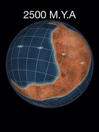
Kenorland was one of the earliest known supercontinents on Earth. It is thought to have formed during the Neoarchaean Era c. 2.72 billion years ago by the accretion of Neoarchaean cratons and the formation of new continental crust. It comprised what later became Laurentia, Baltica, Western Australia and Kalaharia.
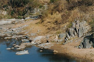
Greenstone belts are zones of variably metamorphosed mafic to ultramafic volcanic sequences with associated sedimentary rocks that occur within Archaean and Proterozoic cratons between granite and gneiss bodies.

The Yilgarn Craton is a large craton that constitutes the bulk of the Western Australian land mass. It is bounded by a mixture of sedimentary basins and Proterozoic fold and thrust belts. Zircon grains in the Jack Hills, Narryer Terrane have been dated at ~4.27 Ga, with one detrital zircon dated as old as 4.4 Ga.

The Slave Craton is an Archaean craton in the north-western Canadian Shield, in Northwest Territories and Nunavut. The Slave Craton includes the 4.03 Ga-old Acasta Gneiss which is one of the oldest dated rocks on Earth. Covering about 300,000 km2 (120,000 sq mi), it is a relatively small but well-exposed craton dominated by ~2.73–2.63 Ga greenstones and turbidite sequences and ~2.72–2.58 Ga plutonic rocks, with large parts of the craton underlain by older gneiss and granitoid units. The Slave Craton is one of the blocks that compose the Precambrian core of North America, also known as the palaeocontinent Laurentia.
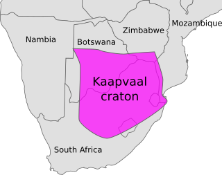
The Kaapvaal Craton, along with the Pilbara Craton of Western Australia, are the only remaining areas of pristine 3.6–2.5 Ga crust on Earth. Similarities of rock records from both these cratons, especially of the overlying late Archean sequences, suggest that they were once part of the Vaalbara supercontinent.

The Churchill Craton is the northwest section of the Canadian Shield and stretches from southern Saskatchewan and Alberta to northern Nunavut. It has a very complex geological history punctuated by at least seven distinct regional tectonometamorphic intervals, including many discrete accretionary magmatic events. The Western Churchill province is the part of the Churchill Craton that is exposed north and west of the Hudson Bay. The Archean Western Churchill province contributes to the complicated and protracted tectonic history of the craton and marks a major change in the behaviour of the Churchill Craton with many remnants of Archean supracrustal and granitoid rocks.

The Temagami Greenstone Belt (TGB) is a small 2.7 billion year old greenstone belt in the Temagami region of Northeastern Ontario, Canada. It represents a feature of the Superior craton, an ancient and stable part of the Earth's lithosphere that forms the core of the North American continent and Canadian Shield. The belt is composed of metamorphosed volcanic rocks that range in composition from basalt to rhyolite. These form the east-northeast trend of the belt and are overlain by metamorphosed sedimentary rocks. They were created during several volcanic episodes involving a variety of eruptive styles ranging from passive lava eruptions to viscous explosive eruptions.
The Trans-Hudson orogeny or Trans-Hudsonian orogeny was the major mountain building event (orogeny) that formed the Precambrian Canadian Shield and the North American Craton, forging the initial North American continent. It gave rise to the Trans-Hudson orogen (THO), or Trans-Hudson Orogen Transect (THOT), which is the largest Paleoproterozoic orogenic belt in the world. It consists of a network of belts that were formed by Proterozoic crustal accretion and the collision of pre-existing Archean continents. The event occurred 2.0–1.8 billion years ago.

The Algoman orogeny, known as the Kenoran orogeny in Canada, was an episode of mountain-building (orogeny) during the Late Archean Eon that involved repeated episodes of continental collisions, compressions and subductions. The Superior province and the Minnesota River Valley terrane collided about 2,700 to 2,500 million years ago. The collision folded the Earth's crust and produced enough heat and pressure to metamorphose the rock. Blocks were added to the Superior province along a 1,200 km (750 mi) boundary that stretches from present-day eastern South Dakota into the Lake Huron area. The Algoman orogeny brought the Archean Eon to a close, about 2,500 million years ago; it lasted less than 100 million years and marks a major change in the development of the Earth's crust.
The Wopmay orogen is a Paleoproterozoic orogenic belt in northern Canada which formed during the collision between the Hottah terrane, a continental magmatic arc, and the Archean Slave Craton at about 1.88 Ga. The collision lead to the short-lived Calderian orogeny. The formation was named for Wilfrid Reid "Wop" May, OBE, DFC, a Canadian flying ace in the First World War and a leading post-war aviator.

The geology of Zimbabwe in southern Africa is centered on the Zimbabwe Craton, a core of Archean basement composed in the main of granitoids, schist and gneisses. It also incorporates greenstone belts comprising mafic, ultramafic and felsic volcanics which are associated with epiclastic sediments and iron formations. The craton is overlain in the north, northwest and east by Proterozoic and Phanerozoic sedimentary basins whilst to the northwest are the rocks of the Magondi Supergroup. Northwards is the Zambezi Belt and to the east the Mozambique Belt. South of the Zimbabwe Craton is the Kaapvaal Craton separated from it by the Limpopo Mobile Belt, a zone of deformation and metamorphism reflecting geological events from Archean to Mesoproterozoic times. The Zimbabwe Craton is intruded by an elongate ultramafic/mafic igneous complex known as the Great Dyke which runs for more than 500 km along a SSW/NNE oriented graben. It consists of peridotites, pyroxenites, norites and bands of chromitite.

The Barberton greenstone belt (BGB) is located in the Kapvaal craton of southeastern Africa. It characterizes one of the most well-preserved and oldest pieces of continental crust today by containing rocks in the Barberton Granite Greenstone Terrain (3.55–3.22 Ga). The BGB is a small, cusp-shaped succession of volcanic and sedimentary rocks, surrounded on all sides by granitoid plutons which range in age from >3547 to <3225 Ma. It is commonly known as the type locality of the ultramafic, extrusive volcanic rock, the komatiite. Greenstone belts are geologic regions generally composed of mafic to ultramafic volcanic sequences that have undergone metamorphism. These belts are associated with sedimentary rocks that occur within Archean and Proterozoic cratons between granitic bodies. Their name is derived from the green hue that comes from the metamorphic minerals associated with the mafic rocks. These regions are theorized to have formed at ancient oceanic spreading centers and island arcs. In simple terms, greenstone belts are described as metamorphosed volcanic belts. Being one of the few most well-preserved Archean portions of the crust, with Archean felsic volcanic rocks, the BGB is well studied. It provides present geologic evidence of Earth during the Archean (pre-3.0 Ga). Despite the BGB being a well studied area, its tectonic evolution has been the cause of much debate.
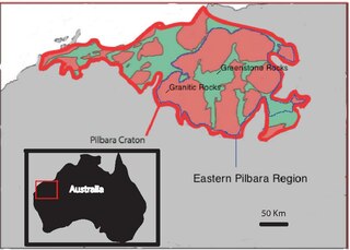
The Eastern Pilbara Craton is the eastern portion of the Pilbara Craton located in Western Australia. This region contains variably metamorphosed mafic and ultramafic greenstone belt rocks, intrusive granitic dome structures, and volcanic sedimentary rocks. These greenstone belts worldwide are thought to be the remnants of ancient volcanic belts, and are subject to much debate in today's scientific community. Areas such as Isua and Barberton which have similar lithologies and ages as Pilbara have been argued to be subduction accretion arcs, while others suggest that they are the result of vertical tectonics. This debate is crucial to investigating when/how plate tectonics began on Earth. The Pilbara Craton along with the Kaapvaal Craton are the only remaining areas of the Earth with pristine 3.6–2.5 Ga crust. The extremely old and rare nature of this crustal region makes it a valuable resource in the understanding of the evolution of the Archean Earth.

Eoarchean geology is the study of the oldest preserved crustal fragments of Earth during the Eoarchean era from 4.031 to 3.6 billion years ago. Major well-preserved rock units dated Eoarchean are known from three localities, the Isua Greenstone Belt in Southwest Greenland, the Acasta Gneiss in the Slave Craton in Canada, and the Nuvvuagittuq Greenstone Belt in the eastern coast of Hudson Bay in Quebec. From the dating of rocks in these three regions scientists suggest that plate tectonics could go back as early as Eoarchean.

The geology of Sierra Leone is primarily very ancient Precambrian Archean and Proterozoic crystalline igneous and metamorphic basement rock, in many cases more than 2.5 billion years old. Throughout Earth history, Sierra Leone was impacted by major tectonic and climatic events, such as the Leonean, Liberian and Pan-African orogeny mountain building events, the Neoproterozoic Snowball Earth and millions of years of weathering, which has produced thick layers of regolith across much of the country's surface.

Archean felsic volcanic rocks are felsic volcanic rocks that were formed in the Archean Eon. The term "felsic" means that the rocks have silica content of 62–78%. Given that the Earth formed at ~4.5 billion year ago, Archean felsic volcanic rocks provide clues on the Earth's first volcanic activities on the Earth's surface started 500 million years after the Earth's formation.
The geology of Nunavut began to form nearly three billion years ago in the Archean and the territory preserves some of the world's oldest rock units.

The Eastern Block of the North China Craton is one of the Earth's oldest pieces of continent. It is separated from the Western Block by the Trans-North China Orogen. It is situated in northeastern China and North Korea. The Block contains rock exposures older than 2.5 billion years. It serves as an ideal place to study how the crust was formed in the past and the related tectonic settings.
The Superior Craton is a stable crustal block covering Quebec, Ontario, and southeast Manitoba in Canada, and northern Minnesota in the United States. It is the biggest craton among those formed during the Archean period. A craton is a large part of the Earth's crust that has been stable and subjected to very little geological changes over a long time. The size of Superior Craton is about 1,572,000 km2. The craton underwent a series of events from 4.3 to 2.57 Ga. These events included the growth, drifting and deformation of both oceanic and continental crusts.

The geology of the Kimberley, a region of Western Australia, is a rock record of early Proterozoic plate collision, orogeny and suturing between the Kimberley Craton and the Northern Australia Craton, followed by sedimentary basin formation from Proterozoic to Phanerozoic.
References
- ↑ Aspler, Lawrence B.; Chiarenzelli, Jeffrey R. (1996). "Stratigraphy, sedimentology and physical volcanology of the Henik Group, central Ennadai-Rankin greenstone belt, Northwest Territories, Canada: late Archean paleogeography of the Hearne Province and tectonic implications". Precambrian Research. 77 (1–2): 59–89. doi:10.1016/0301-9268(95)00045-3.
- ↑ Padgham, W. A.; Fyson, W. K. (1992). "The Slave Province: a distinct Archean craton". Canadian Journal of Earth Sciences. 29 (10): 2072–2086. doi:10.1139/e92-165.
- ↑ Fyson, W. K.; Helmstaedt, H. (1988). "Structural patterns and tectonic evolution of supracrustal domains in the Archean Slave Province, Canada". Canadian Journal of Earth Sciences. 25 (2): 301–315. doi:10.1139/e88-032.
- ↑ Henderson, John B. (1975). "Archean Stromatolites in the Northern Slave Province, Northwest Territories, Canada". Canadian Journal of Earth Sciences. 12 (9): 1619–1630. doi:10.1139/e75-144.
- ↑ Dupuy, C.; Michard, A.; Dostal, J.; Dautel, D.; Baragar, W. R. A. (1992). "Proterozoic flood basalts from the Coppermine River area, Northwest Territories: isotope and trace element geochemistry". Canadian Journal of Earth Sciences. 29 (9): 1937–1943. doi:10.1139/e92-151.
- ↑ Turner, Elizabeth C.; Long, Darrel G.F. (2008). "Basin architecture and syndepositional fault activity during deposition of the Neoproterozoic Mackenzie Mountains supergroup, Northwest Territories, CanadaNorthwest Territories Geoscience Office Contribution 0040". Canadian Journal of Earth Sciences. 45 (10): 1159–1184. doi:10.1139/E08-062.
- ↑ Corlett, Hilary; Jones, Brian (2011). "Ecological controls on Devonian stromatoporoid-dominated and coral-dominated reef growth in the Mackenzie Basin, Northwest Territories, Canada". Canadian Journal of Earth Sciences. 48 (12): 1543–1560. doi:10.1139/e11-056.
- ↑ Riediger, C.; Goodarzi, F.; MacQueen, R. W. (1989). "Graptolites as indicators of regional maturity in lower Paleozoic sediments, Selwyn Basin, Yukon and Northwest Territories, Canada". Canadian Journal of Earth Sciences. 26 (10): 2003–2015. doi:10.1139/e89-169.
- ↑ Dewing, Keith; Copper, Paul (1991). "Upper Ordovician stratigraphy of Southampton Island, Northwest Territories". Canadian Journal of Earth Sciences. 28 (2): 283–291. doi:10.1139/e91-027.
- ↑ Nowicki, Tom; Crawford, Barbara; Dyck, Darren; Carlson, Jon; McElroy, Ross; Oshust, Peter; Helmstaedt, Herb (2004). "The geology of kimberlite pipes of the Ekati property, Northwest Territories, Canada". Lithos. 76 (1–4): 1–27. doi:10.1016/j.lithos.2004.03.020.
- ↑ Miall, Andrew D. (1974). "Manganese Spherulites at an Intra-Cretaceous Disconformity, Banks Island, Northwest Territories". Canadian Journal of Earth Sciences. 11 (12): 1704–1716. doi:10.1139/e74-168.
- ↑ O'Sullivan, Paul B.; Lane, Larry S. (1997). "Early Tertiary thermotectonic history of the northern Yukon and adjacent Northwest Territories, Arctic Canada". Canadian Journal of Earth Sciences. 34 (10): 1366–1378. doi:10.1139/e17-109.
- ↑ Duk-Rodkin, A.; Barendregt, R. W.; Tarnocai, C.; Phillips, F. M. (1996). "Late Tertiary to late Quaternary record in the Mackenzie Mountains, Northwest Territories, Canada: stratigraphy, paleosols, paleomagnetism, and chlorine - 36". Canadian Journal of Earth Sciences. 33 (6): 875–895. doi:10.1139/e96-066.
- ↑ "Quaternary geology of the Tuktoyaktuk coastlands, Northwest Territories (Technical Report) | ETDEWEB". osti.gov. Retrieved 2018-11-10.
- ↑ Dallimore, S. R.; Collett, T. S. (1995). "Intrapermafrost gas hydrates from a deep core hole in the Mackenzie Delta, Northwest Territories, Canada | Geology". Geology. 23 (6): 527. doi:10.1130/0091-7613(1995)023<0527:IGHFAD>2.3.CO;2.
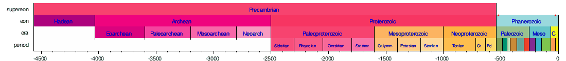
The following five timelines show the geologic time scale to scale. The first shows the entire time from the formation of the Earth to the present, but this gives little space for the most recent eon. The second timeline shows an expanded view of the most recent eon. In a similar way, the most recent era is expanded in the third timeline, the most recent period is expanded in the fourth timeline, and the most recent epoch is expanded in the fifth timeline.


Thousands of years (5th)