Related Research Articles
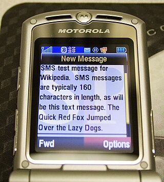
Short Message/Messaging Service, commonly abbreviated as SMS, is a text messaging service component of most telephone, Internet and mobile device systems. It uses standardized communication protocols that let mobile devices exchange short text messages. An intermediary service can facilitate a text-to-voice conversion to be sent to landlines.

A geotagged photograph is a photograph which is associated with a geographic position by geotagging. Usually this is done by assigning at least a latitude and longitude to the image, and optionally elevation, compass bearing and other fields may also be included.
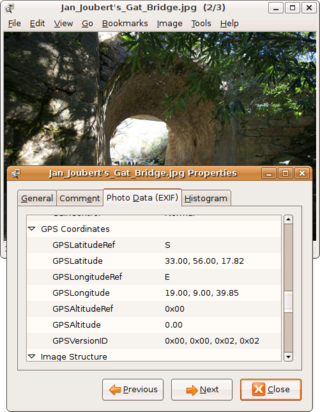
Geotagging, or GeoTagging, is the process of adding geographical identification metadata to various media such as a geotagged photograph or video, websites, SMS messages, QR Codes or RSS feeds and is a form of geospatial metadata. This data usually consists of latitude and longitude coordinates, though they can also include altitude, bearing, distance, accuracy data, and place names, and perhaps a time stamp.
Push technology, also known as server push, refers to a communication method, where the communication is initiated by a server rather than a client. This approach is different from the "pull" method where the communication is initiated by a client.
Push Access Protocol is a protocol defined in WAP-164 of the Wireless Application Protocol (WAP) suite from the Open Mobile Alliance. PAP is used for communicating with the Push Proxy Gateway, which is usually part of a WAP Gateway.
Emailtracking is a method for monitoring whether the email message is read by the intended recipient. Most tracking technologies use some form of digitally time-stamped record to reveal the exact time and date when an email is received or opened, as well as the IP address of the recipient.
Mobile marketing is a multi-channel online marketing technique focused at reaching a specific audience on their smartphones, feature phones, tablets, or any other related devices through websites, e-mail, SMS and MMS, social media, or mobile applications. Mobile marketing can provide customers with time and location sensitive, personalized information that promotes goods, services, appointment reminders and ideas. In a more theoretical manner, academic Andreas Kaplan defines mobile marketing as "any marketing activity conducted through a ubiquitous network to which consumers are constantly connected using a personal mobile device".
Mobile app development is the act or process by which a mobile app is developed for one or more mobile devices, which can include personal digital assistants (PDA), enterprise digital assistants (EDA), or mobile phones. Such software applications are specifically designed to run on mobile devices, taking numerous hardware constraints into consideration. Common constraints include CPU architecture and speeds, available memory (RAM), limited data storage capacities, and considerable variation in displays and input methods. These applications can be pre-installed on phones during manufacturing or delivered as web applications, using server-side or client-side processing to provide an "application-like" experience within a web browser.
Geo is a microformat used for marking up geographical coordinates in HTML. Coordinates are expected in angular units of degrees and geodetic datum WGS84. Although termed a "draft" specification, the format is a de facto standard, stable and in widespread use; not least as a sub-set of the published hCalendar and hCard microformat specifications, neither of which is still a draft.

Geosocial networking is a type of social networking in which geographic services and capabilities such as geocoding and geotagging are used to enable additional social dynamics. User-submitted location data or geolocation techniques can allow social networks to connect and coordinate users with local people or events that match their interests. Geolocation on web-based social network services can be IP-based or use hotspot trilateration. For mobile social networks, texted location information or mobile phone tracking can enable location-based services to enrich social networking.
Real-time geotagging refers to the automatic technique of acquiring media, associating a specific location with the media, transferring the media to an online map and publishing the media in real time. It is thus an extension of an automatic geotagging process, requiring an in-built or attached location acquisition device, but also requires communication with a wireless data transfer device. Most modern smartphones and several digital cameras already integrate camera, aGPS, and wireless data transfer into one device, thus directly producing a geotagged photograph. Real-time geotagging is sometimes referred to as "mobile geotagging" or "autogeotagging", but this does not imply the real-time publishing step.
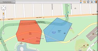
A geofence is a virtual perimeter for a real-world geographic area. A geofence can be dynamically generated or match a predefined set of boundaries.
The W3C Geolocation API is an effort by the World Wide Web Consortium (W3C) to standardize an interface to retrieve the geographical location information for a client-side device. It defines a set of objects, ECMAScript standard compliant, that executing in the client application give the client's device location through the consulting of Location Information Servers, which are transparent for the application programming interface (API). The most common sources of location information are IP address, Wi-Fi and Bluetooth MAC address, radio-frequency identification (RFID), Wi-Fi connection location, or device Global Positioning System (GPS) and GSM/CDMA cell IDs. The location is returned with a given accuracy depending on the best location information source available.
The MMS Architecture is the set of standards used by the Multimedia Messaging Service in mobile networks. The standards are prepared by 3GPP.
GeoSMS is a specification for geotagging SMS messages. It works by embedding locations in the message text, where the locations are formatted as 'geo' URIs as defined in RFC 5870.
GeoReader is a landmark locating software application and website for mobile iPhone and Android based devices. Users travel into the vicinity of a “talking point”, and the software enables the phone to read text aloud that is linked with a GPS location. In addition, users can create their own 200 character count text to add to the database, and choose to share these talking points publicly or privately. The system is hands free and requires no physical interaction. Once the app is installed in the mobile device, the user simply opens the app and starts their trip. The application automatically then starts to search for any GPS tagged talking points within range of the user.

Google Cloud Messaging (GCM) was a mobile notification service developed by Google that enables third-party application developers to send notification data or information from developer-run servers to applications that target the Google Android Operating System, as well as applications or extensions developed for the Google Chrome internet browser. It was available to developers free of charge. The GCM Service was first announced in June 2012 as a successor to Google's now-defunct Android Cloud to Device Messaging (C2DM) service, citing improvements to authentication and delivery, new API endpoints and messaging parameters, and the removal of limitations on API send-rates and message sizes. It has been superseded by Google's Firebase Cloud Messaging (FCM) on May 29, 2019.
Bluetooth beacons are hardware transmitters — a class of Bluetooth Low Energy (LE) devices that broadcast their identifier to nearby portable electronic devices. The technology enables smartphones, tablets and other devices to perform actions when in close proximity to a beacon.
Firebase Cloud Messaging (FCM), formerly known as Google Cloud Messaging (GCM), is a cross-platform cloud service for messages and notifications for Android, iOS, and web applications, which as of May 2023 can be used at no cost. Firebase Cloud Messaging allows third-party application developers to send notifications or messages from servers hosted by FCM to users of the platform or end users.

Geopositioning is the process of determining or estimating the geographic position of an object.
References
- ↑ Fujioka, Masanobu; Takahashi, Masanori; Matsumura, Takeshi; Chunmeng Wang; Hirakoba, Hiroyuki (2012). 2012 12th International Conference on ITS Telecommunications. IEEE. pp. 497–501. doi:10.1109/ITST.2012.6425228. ISBN 978-1-4673-3070-1. S2CID 26873176.
- ↑ "Location Based Messaging for Events and Venue Crisis and Incident Management" (PDF). UgoRound.com. 21 July 2017. Archived from the original (PDF) on 26 September 2017. Retrieved 25 September 2017.
- ↑ Loyola L, Wong F, Pereira D, et al. (5 November 2016). "Extending battery lifetime of mobile devices with geofence capabilities on dynamic-speed urban environments". Proceedings of the Second ACM SIGSPATIAL International Workshop on Mobile Geographic Information Systems - MobiGIS '13. MobiGIS13. pp. 51–58. doi:10.1145/2534190.2534193. ISBN 9781450325318. S2CID 8655696 . Retrieved 25 November 2016.
- ↑ "Geo-fencing in Push Notifications: The Next Step in User Engagement". ShepHertz. 5 May 2016. Retrieved 24 September 2017.[ permanent dead link ]