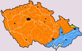
The Carpathian Mountains or Carpathians are a range of mountains forming an arc across Central Europe. Roughly 1,500 km (930 mi) long, it is the third-longest European mountain range after the Urals at 2,500 km (1,600 mi) and the Scandinavian Mountains at 1,700 km (1,100 mi). The range stretches from the far eastern Czech Republic (3%) and Austria (1%) in the northwest through Slovakia (21%), Poland (10%), Ukraine (10%), Romania (50%) to Serbia (5%) in the south. The highest range within the Carpathians is known as the Tatra mountains in Poland and Slovakia, where the highest peaks exceed 2,600 m (8,500 ft). The second-highest range is the Southern Carpathians in Romania, where the highest peaks range between 2,500 m (8,200 ft) and 2,550 m (8,370 ft).
Outer Subcarpathia denotes the depression area at the outer base of the Carpathian arc, including foothills of the Outer Western Carpathians and Outer Eastern Carpathians. It stretches from northeastern Austria, through eastern Czech Republic, southern Poland, western Ukraine and northeastern Romania.
The Tuchola Forest, also known as Tuchola Pinewoods or Tuchola Conifer Woods, is a large forest complex near the town of Tuchola in northern Poland. It lies between the Brda and Wda rivers, within the Gdańsk Pomerania region. The largest towns in the area are Czersk and Tuchola.

The Pannonian Basin, or Carpathian Basin, is a large sedimentary basin situated in southeast Central Europe. After the WW1 and Treaty of Trianon, the geomorphological term Pannonian Plain became more widely used for roughly the same region though with a somewhat different sense, with only the lowlands, the plain that remained when the Pliocene Epoch Pannonian Sea dried out.

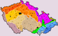
Divisions of the Carpathians are a categorization of the Carpathian mountains system.

The Ještěd–Kozákov Ridge is a ridge and geomorphological mesoregion of the Czech Republic. It is part of the Western Sudetes. The vast majority lies in the Liberec Region.

The Western Carpathians are a mountain range and geomorphological province that forms the western part of the Carpathian Mountains.

The Western Sudetes are a geomorphological macroregion, the western part of the Sudetes subprovince on the borders of the Czech Republic, Poland and Germany.
The Romanian Carpathians are a section of the Carpathian Mountains, within the borders of modern Romania. The Carpathians are a "subsystem" of the Alps-Himalaya System and are further divided into "provinces" and "subprovinces".
Moravian-Silesian Foothills are foothills and a geomorphological mesoregion of the Czech Republic.

The Bohemian Massif is a geomorphological province in Central Europe. It is a large massif stretching over most of the Czech Republic, eastern Germany, southern Poland and northern Austria.

The Most Basin is a structural basin and geomorphological mesoregion of the Czech Republic. It is named after the city of Most. It forms the southwestern and central parts of the Ústí nad Labem Region. It is among the richest European deposits of lignite, which has been extracted here since the second half of 19th century, mostly by extensive surface mining.

The Sokolov Basin or Falkenau Basin is a structural basin and geomorphological mesoregion of the Czech Republic. It is located in the central part of the Karlovy Vary Region. It is named after the town of Sokolov. It is known for its deposits of lignite, which has been extracted here to a greater extent since the second half of 19th century.
The Vizovice Highlands are highlands and a geomorphological mesoregion of the Czech Republic. It is located in the Zlín and South Moravian regions. It is named after the town of Vizovice.

Topography of Croatia is defined through three major geomorphological parts of the country. Those are the Pannonian Basin, the Dinaric Alps, and the Adriatic Basin. The largest part of Croatia consists of lowlands, with elevations of less than 200 metres above sea level recorded in 53.42% of the country. Bulk of the lowlands are found in the northern regions of the country, especially in Slavonia, itself a part of the Pannonian Basin plain. The plains are interspersed by the horst and graben structures, believed to break the Pannonian Sea surface as islands. The greatest concentration of ground at relatively high elevations is found in Lika and Gorski Kotar areas in the Dinaric Alps, but such areas are found in all regions of Croatia to some extent. The Dinaric Alps contain the highest mountain in Croatia—1,831-metre (6,007 ft) Dinara, as well as all other mountains in Croatia higher than 1,500 metres. Croatia's Adriatic Sea mainland coast is 1,777.3 kilometres long, while its 1,246 islands and islets encompass further 4,058 kilometres of coastline—the most indented coastline in the Mediterranean. Karst topography makes up about half of Croatia and is especially prominent in the Dinaric Alps, as well as throughout the coastal areas and the islands.

The Brno Highlands are highlands and a geomorphological macroregion of the Czech Republic. It is located mainly in the South Moravian Region, but it also extends into the Olomouc and Pardubice regions.
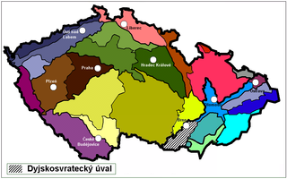
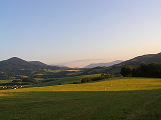
The Dyje–Svratka Valley is a valley and a geomorphological mesoregion of the Czech Republic. It is located in the South Moravian Region. Its name is derived from the rivers Thaya (Dyje) and Svratka.

The Ostrava Basin is a lowland and a geomorphological mesoregion of the Czech Republic and Poland. It is located in the Moravian-Silesian Region of the Czech Republic and in the Silesian Voivodeship of Poland.

The Prague Plateau is a plateau and a geomorphological mesoregion of the Czech Republic. It is located in the area of Prague and in the Central Bohemian Region.

The Central Elbe Table is a plateau and a geomorphological mesoregion of the Czech Republic. It is located mostly in the Central Bohemian Region, but due to its size, it also extends to other regions. The axis of the plateau is the Elbe river, after which the territory is named.