
Nigeria, officially the Federal Republic of Nigeria, is a country in West Africa. It is situated between the Sahel to the north and the Gulf of Guinea to the south in the Atlantic Ocean. It covers an area of 923,769 square kilometres (356,669 sq mi), and with a population of over 225 million, it is the most populous country in Africa, and the world's sixth-most populous country. Nigeria borders Niger in the north, Chad in the northeast, Cameroon in the east, and Benin in the west. Nigeria is a federal republic comprising 36 states and the Federal Capital Territory, where the capital, Abuja, is located. The largest city in Nigeria is Lagos, one of the largest metropolitan areas in the world and the second-largest in Africa.
Akwa Ibom State is a state in the South-South geopolitical zone of Nigeria, bordered on the east by Cross River State, on the west by Rivers State and Abia State, and on the south by the Atlantic Ocean. The state takes its name from the Qua Iboe River which bisects the state before flowing into the Bight of Bonny. Akwa Ibom was split from Cross River State in 1987 with its capital Uyo and with 31 local government areas.
Delta State is a state in the South-east geopolitical zone of Nigeria. Named after the Niger Delta—a large part of which is in the state—the state was formed from the former Bendel State on August 27, 1991. Bordered on the north by Edo State, the east by Anambra and Rivers States, and the south by Bayelsa State while to the west is the Bight of Benin which covers about 160 kilometres of the state's coastline. The State was initially created with 12 local government areas in 1991 which was later extended to 19 and now has 25 local government areas. Asaba as its state capital is located along the River Niger on the northeastern end of the State, while the state's economic centre is the twin cities of Warri and Uvwie
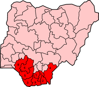
The Niger Delta is the delta of the Niger River sitting directly on the Gulf of Guinea on the Atlantic Ocean in Nigeria. It is located within nine coastal southern Nigerian states, which include: all six states from the South South geopolitical zone, one state (Ondo) from South West geopolitical zone and two states from South East geopolitical zone.

Rivers State, also known as Rivers, is a state in the Niger Delta region of southern Nigeria. Formed in 1967, when it was split from the former Eastern Region, Rivers State borders include: Imo to the north, Abia and Akwa Ibom to the east, and Bayelsa and Delta to the west. The state capital, Port Harcourt, is a metropolis that is considered to be the commercial center of the Nigerian oil industry.

Borno State is a state in the North-East geopolitical zone of Nigeria, bordered by Yobe to the west, Gombe to the southwest, and Adamawa to the south while its eastern border forms part of the national border with Cameroon, its northern border forms part of the national border with Niger, and its northeastern border forms all of the national border with Chad, being the only Nigerian state to border three foreign countries. It takes its name from the historic emirate of Borno, with the emirate's old capital of Maiduguri serving as the capital city of Borno State. The state was formed in 1976 when the former North-Eastern State was broken up. It originally included the area that is now Yobe State, which became a distinct state in 1991.
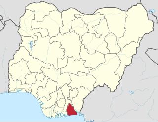
Oguta is a town on the east bank of Oguta Lake in Imo State of southeastern Nigeria.

Nigeria is the second largest oil and gas producer in Africa. Crude oil from the Niger delta basin comes in two types: light, and comparatively heavy – the lighter has around 36 gravity while the heavier has 20–25 gravity. Both types are paraffinic and low in sulfur. Nigeria's economy and budget have been largely supported from income and revenues generated from the petroleum industry since 1960. Statistics as at February 2021 shows that the Nigerian oil sector contributes to about 9% of the entire GDP of the nation. Nigeria is the largest oil and gas producer in Africa, a major exporter of crude oil and petroleum products to the United States of America. In 2010, Nigeria exported over one million barrels per day to the United States, representing 9% of the U.S. total crude oil and petroleum products imports and over 40% of Nigeria exports.
The Middle Belt is a term used in human geography to designate a belt region stretching across central Nigeria longitudinally and forming a transition zone between Northern and Southern Nigeria. It is composed of the southern half of the defunct Northern Region of Nigeria, now comprising mostly the North Central geopolitical zone, and is characterised by its lack of a clear majority ethnic group. It is also the location of Nigeria's Federal Capital Territory.

Colonial Nigeria was ruled by the British Empire from the mid-nineteenth century until 1960 when Nigeria achieved independence. British influence in the region began with the prohibition of slave trade to British subjects in 1807. Britain annexed Lagos in 1861 and established the Oil River Protectorate in 1884. British influence in the Niger area increased gradually over the 19th century, but Britain did not effectively occupy the area until 1885. Other European powers acknowledged Britain's dominance over the area in the 1885 Berlin Conference.
The First Republic was the republican government of Nigeria between 1963 and 1966 governed by the first republican constitution. The country's government was based on a federal form of the Westminster system. The period between 1 October 1960, when the country gained its independence and 15 January 1966, when the first military coup d’état took place, is also generally referred to as the First Republic. The first Republic of Nigeria was ruled by different leaders representing their regions as premiers in a federation during this period. Leaders include Ahmadu Bello Northern Nigeria 1959–1966, Obafemi Awolowo Western Nigeria 1959–1960, Samuel Akintola Western Nigeria 1960–1966, Michael Okpara Eastern Nigeria 1960–1966, and Dennis Osadebay Mid-Western Nigeria 1964–1966.
The Niger Delta Congress (NDC) is a socio-political organization of the ethnic nationalities of the Niger Delta region. The NDC was established on the 26th of December 2019 in Port-Harcourt, Rivers State, to serve the purpose of uniting the minority nationalities of the Niger Delta region as a means to achieving political and economic autonomy for the peoples of the region. The NDC is under the leadership of an executive council that comprises representatives of the different nationalities that make up the region. The current executive of the NDC which is in acting capacity is led by Nubari Saatah as President, and Mudiaga Ogboru as its National Spokesperson.
Federalism in Nigeria refers to the devolution of self-governance by the West African nation of Nigeria to its federated states, who share sovereignty with the Federal Government.
Senator Ifeanyi Godwin Araraume was born on 16 December 1958 to Late Mr. Marcus Araraume and Mrs. Adaezi Grace Araraume at Isiebu, Umuduru in Isiala Mbano Local Government Area of Imo State, Nigeria.
The Kaiama Declaration was issued by the Ijaw Youth Council (IYC) of Nigeria on 11 December 1998 to attribute the political crisis in Nigeria to the struggle for the control of oil mineral resources, while asserting that the degradation of the environment of Ijawland by transnational oil companies and the Nigerian State arise mainly because Ijaw people have been robbed of their natural rights to ownership and control of their land and resources. The council was formed in the town of Kaiama after 5,000 Ijaw people representing over 40 Ijaw clans, chose to articulate their aspirations for the Ijaw people, and to demand an end to 40 years of environmental damage and underdevelopment in the region.
The South South is the one of the six geopolitical zones of Nigeria representing both a geographic and political region of the country's eastern coast. It comprises six states – Akwa Ibom, Bayelsa, Cross River, Delta, Edo, and Rivers.
The South East is the one of the six geopolitical zones of Nigeria representing both a geographic and political region of the country's inland southeast. It comprises five states – Abia, Anambra, Ebonyi, Enugu, and Imo.
The Niger Delta Youth Association is a non-militia advocacy group dedicated to advancing the cause of human rights, accountability and development in the Niger Delta region of Nigeria. It was founded around 2015. Though the group is built on a threefold purpose to relieve poverty, conserve the environment and to promote employment opportunities for people living in Niger Delta especially young people but the group has been known to peacefully campaign for such issues as youths in politics, Niger Delta clean up, peaceful cohabitation, Poverty alleviation, Development and accountability in the Niger Delta Region.
