
The Metropolitan Borough of St Marylebone was a metropolitan borough of the County of London from 1900 to 1965. It was based directly on the previously existing civil parish of St Marylebone, Middlesex, which was incorporated into the Metropolitan Board of Works area in 1855, retaining a parish vestry, and then became part of the County of London in 1889.

Marie Adelaide Elizabeth Rayner Lowndes, who wrote as Marie Belloc Lowndes, was a prolific English novelist, and sister of author Hilaire Belloc.

The Lodger is a novel by English author Marie Adelaide Belloc Lowndes. The short story was first published in the January, 1911 edition of McClure's Magazine, in 1911. Belloc Lowndes wrote a longer version of the story, which was published as a series in the Daily Telegraph in 1913 with the same name. Later that year, the novel was published in its entirety by Methuen Publishing.

Greenwell Street, formerly Buckingham Street, is located in the Fitzrovia district of the City of Westminster in London. It was built in the late eighteenth century and runs between Bolsover Street in the east and Cleveland Street in the west. Great Titchfield Street joins it on its south side. On the south side is the grade II listed George and Dragon public house (c.1850) and the site of the home of the sculptor John Flaxman, the location of which is marked by a plaque.
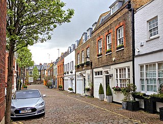
Devonshire Close, originally known as Devonshire Mews East, is a mews street in the City of Westminster, London, accessed from Devonshire Street. The Close is on a distinctive H plan with a middle downwards leg. It dates from the 1770s and originally contained a timber yard, stables, and accommodation for domestic servants who worked in the larger houses surrounding it. Access was limited to the north side in order to divert traffic from the grander north–south streets around it. The Close was gentrified in the 20th century and its buildings converted to mews houses which, like other mews in London, have become desirable in the modern era because they are quiet and have little traffic. The Close is now part of the Howard de Walden Estate.

Homer Row is a street in the Marylebone district of the City of Westminster, London, that runs form Old Marylebone Road in the north to the junction of Crawford Place and Crawford Street in the south.
This is a list of the etymology of street names in the London district of Marylebone. The following utilises the generally accepted boundaries of Marylebone viz. Marylebone Road to the north, Great Portland Street to the east, Marble Arch and Oxford Street to the south and Edgware Road to the west.
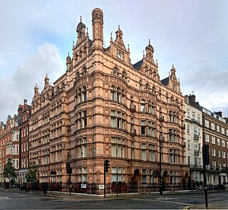
Wimpole House at 28–29a Wimpole Street is a group of Grade II listed town houses on the corner of Wimpole Street and New Cavendish Street in the City of Westminster, London.

Gloucester Place is a street in Marylebone in Central London. Located in the City of Westminster, it runs north from Portman Square across the Marylebone Road eventually merging into Park Road. It is parallel to Baker Street to the east and forms part of the A41 road from nearby Marble Arch.

Seymour Place is a street in Marylebone in Central London. Located in the City of Westminster, it runs north from Seymour Street until it meets Marylebone Road, where it becomes Lisson Grove. It is crossed by Crawford Street, George Street, and York Street and runs parallel to Gloucester Place, which lies to its east. Its southern end is about 180 metres northwest of Marble Arch and about 40 metres east of Edgware Road.

York Street is a street in Marylebone in Central London. Located in the City of Westminster, it runs west from Baker Street in a straight line until it begins curving when it becomes Harcourt Street towards the Old Marylebone Road. It crosses a number of streets including Seymour Place, Upper Montagu Street and Gloucester Place.

Church Street is a thoroughfare in Marylebone, located in West London, and is within the West End of London. Located in the City of Westminster, it runs from Lisson Grove on a south west diagonal crossing Edgware Road and finishing at Paddington Green and the nearby St Mary's Church, from which the street gets its name. The Church Street electoral ward is named after the street.

Gloucester Terrace is a street in Central London in the vicinity of Paddington and Bayswater. Located in the City of Westminster, it runs northwards from Lancaster Terrace near to Lancaster Gate tube station and Hyde Park before curving round to meet Porchester Square around Westbourne. The southern section is close to the border between Tyburnia and Bayswater. It intersects with Craven Road, Chilworth Street, Cleveland Terrace, Bishop's Bridge Road and Orsett Terrace. Its northern section is close to the Great Western Main Line and Westway. Westbourne Terrace runs directly parallel to the east.

Carlton Vale is a street that runs through Kilburn and Maida Vale in London. Some of its route forms the boundary between the City of Westminster to the south and the London Borough of Brent to the north. To the west the street continues as Kilburn Lane through Queen's Park, while to the east it becomes Carlton Hill running into St. John's Wood. Carlton Vale crosses or meets several roads including Kilburn Park Road, Cambridge Road and Randolph Avenue.

Regent's Park Road is a street in the Primrose Hill area of London, England. Located in the London Borough of Camden, it runs in a curving crescent shape. For some of its route it follows alongside the eastern edge of Primrose Hill park and also includes the commercial centre of the area. Despite its name the street does not run as far as Regent's Park although the adjacent Prince Albert Road does.

Norfolk Square is a rectangular garden square in Paddington in Central London. Located in the City of Westminster, it is part of the Tyburnia district north of Hyde Park. It runs east to west from London Street to Norfolk Place. Praed Street and Sussex Gardens are directly parallel to it north and south respectively.

Chiltern Street is a road in the Marylebone area of Central London. Located in the City of Westminster, it runs north to south connecting Marylebone Road and Blandford Street. Baker Street runs parallel a little way to the west. It meets Dorset Street, Crawford Street and Paddington Street along its route. Manchester Square is located beyond the southern end of the street.

Connaught Street is a street in Central London. Located in the City of Westminster, it is part of the Tyburnia area of Paddington north of Hyde Park. It runs west to east from Hyde Park Square to the Edgware Road. It continues eastwards becoming Upper Berkeley Street in Marylebone. The street contains a mixture of commercial and residential properties, forming part of Connaught Village. Connaught Square and Albion Street are located on its southern side. The Duke of Kendal public house sits at the junction between Connaught Street and Kendal Street.

Albion Street is a residential street located in Central London in the City of Westminster. Part of the Tyburnia area, it runs southwards from Connaught Street to the Bayswater Road on the edge of Hyde Park. It is notable for its Regency architecture.

Well Road is a street in Hampstead, England located in the London Borough of Camden. It runs westwards from Hampstead Heath to New End Square. Well Walk runs parallel to its south and the two are linked by Wells Passage. When the Hampstead Wells were in existence, a large pump room and assembly room were located on Well Walk, with the water supplied from the headspring on Well Road.


