State Route 125 | ||||
---|---|---|---|---|
Route information | ||||
Maintained by GDOT | ||||
Length | 72.6 mi [1] (116.8 km) | |||
Major junctions | ||||
South end | ||||
North end | ||||
Location | ||||
Counties | Lowndes, Lanier, Berrien, Tift, Irwin, Ben Hill | |||
Highway system | ||||
|
State Route 125 (SR 125) is a 73-mile-long (117 km) state highway that runs south-to-north in an S-shape through the southern part of the U.S. state of Georgia. It travels through Lowndes, Lanier, Berrien, Tift, Irwin, and Ben Hill counties connecting the Valdosta and Fitzgerald metropolitan areas.
In the United States, a state is a constituent political entity, of which there are currently 50. Bound together in a political union, each state holds governmental jurisdiction over a separate and defined geographic territory and shares its sovereignty with the federal government. Due to this shared sovereignty, Americans are citizens both of the federal republic and of the state in which they reside. State citizenship and residency are flexible, and no government approval is required to move between states, except for persons restricted by certain types of court orders. Four states use the term commonwealth rather than state in their full official names.
Georgia is a state in the Southeastern United States. It began as a British colony in 1733, the last and southernmost of the original Thirteen Colonies to be established. Named after King George II of Great Britain, the Province of Georgia covered the area from South Carolina south to Spanish Florida and west to French Louisiana at the Mississippi River. Georgia was the fourth state to ratify the United States Constitution, on January 2, 1788. In 1802–1804, western Georgia was split to the Mississippi Territory, which later split to form Alabama with part of former West Florida in 1819. Georgia declared its secession from the Union on January 19, 1861, and was one of the original seven Confederate states. It was the last state to be restored to the Union, on July 15, 1870. Georgia is the 24th largest and the 8th most populous of the 50 United States. From 2007 to 2008, 14 of Georgia's counties ranked among the nation's 100 fastest-growing, second only to Texas. Georgia is known as the Peach State and the Empire State of the South. Atlanta, the state's capital and most populous city, has been named a global city. Atlanta's metropolitan area contains about 55% of the population of the entire state.
Lowndes County is a county located in the U.S. state of Georgia. As of the 2010 Census the population was 109,233. The county seat is Valdosta. The county was created December 23, 1825.
SR 125 begins at an intersection with U.S. Route 41 (US 41) and SR 7 (Inner Perimeter Road) on the north side of Valdosta. The route runs north-northeast, past Freedom Park and passes through Moody Air Force Base and intersects SR 122 at the meeting point of Lowndes, Berrien, and Lanier counties. It travels to the north along the Berrien–Lanier county line and then jogs slightly to the northeast, entering Lanier County proper. In Berrien County, it curves to the north-northwest before entering Ray City. Here, it meets US 129/SR 11/SR 37 (Main Street). At this intersection, US 129/SR 11 begin a concurrency. The three highways head north-northwest to Nashville. In town, SR 76 (Adel Highway) joins the concurrency through Nashville. In the central part of town, the four concurrent routes intersect SR 168 (East McPherson Avenue). Just after that SR 76 departs to the east on East Marion Avenue, while SR 125 departs to the west on West Marion Avenue. It heads northwest through rural areas of the county and enters Tift County. [1]
An intersection is an at-grade junction where two or more roads meet or cross. Intersections may be classified by number of road segments, traffic controls, and/or lane design.
State Route 7 (SR 7) is a 216.0-mile-long (347.6 km) state highway that travels in a southeast-to-northwest orientation through portions of Lowndes, Cook, Tift, Turner, Crisp, Dooly, Houston, Peach, Crawford, Monroe, Lamar, Pike, and Spalding counties in the southern and central parts of the U.S. state of Georgia. The highway connects the Florida state line southeast of Lake Park to the Griffin area, via Valdosta, Tifton, Cordele, Perry, and Barnesville. The highway is concurrent with either US 41 or US 341 for its entire length, and closely parallels I-75 for much of its length.
Valdosta is a city in and the county seat of Lowndes County, located on the southern border of Georgia, United States. As of 2013, Valdosta has a total population of 56,481, and is the 14th largest city in Georgia.
In Tift County, it intersects US 41/SR 7 next to the Henry Tift Myers Airport, just southeast of Unionville. US 41/SR 7/SR 125 head concurrent to the north. In Tifton, the highway meets US 82/US 319/SR 35/SR 520 (East 5th Street). Farther into town, SR 125 splits off to the northeast and enters Irwin County. It runs northeast until it joins SR 32 (Sycamore Highway). They run concurrent to the northeast, through Irwinville, and to the east-southeast until SR 32 (Mystic Highway) splits off to the southeast. SR 125 curves to the northeast and continues in that direction until it meets its northern terminus, an intersection with SR 107 (Benjamin H. Hill Drive West), at the southwestern edge of Fitzgerald. [1]
Henry Tift Myers Airport is a public use airport located two nautical miles (4 km) southeast of the central business district of Tifton, a city in Tift County, Georgia, United States. It is owned by the Tifton & Tift County Airport Authority. This airport is included in the National Plan of Integrated Airport Systems for 2011–2015, which categorized it as a general aviation facility. It does not have scheduled commercial airline service.
Unionville is a census-designated place (CDP) in Tift County, Georgia, United States. The population was 2,074 at the 2000 census.
Tifton is a city in Tift County, Georgia, United States. The population was 16,869 at the 2010 census. The city is the county seat of Tift County.
The only part of SR 125 that is part of the National Highway System, a system of roadways important to the nation's economy, defense, and mobility, is the section from the US 82/US 319/SR 35/SR 520 intersection in Tifton north to Fitzgerald. [2]
The National Highway System (NHS) is a network of strategic highways within the United States, including the Interstate Highway System and other roads serving major airports, ports, rail or truck terminals, railway stations, pipeline terminals and other strategic transport facilities. Altogether, it constitutes the largest highway system in the world.
County | Location | mi [1] | km | Destinations | Notes | |||
---|---|---|---|---|---|---|---|---|
Lowndes | Valdosta | 0.0 | 0.0 | |||||
Lowndes–Berrien– Lanier county tripoint | | 11.1 | 17.9 | |||||
Lanier | No major junctions | |||||||
Berrien | Ray City | 14.5 | 23.3 | Southern end of US 129/SR 11 concurrency | ||||
Nashville | 23.9 | 38.5 | Southern end of SR 76 concurrency | |||||
24.3 | 39.1 | Western terminus of SR 168 | ||||||
24.4 | 39.3 | Northern end of US 129/SR 11/SR 76 concurrency | ||||||
Tift | | 46.5 | 74.8 | Southern end of US 41/SR 7 concurrency | ||||
Tifton | 48.4 | 77.9 | ||||||
49.3 | 79.3 | Northern end of US 41/SR 7 concurrency | ||||||
Irwin | | 63.0 | 101.4 | Southern end of SR 32 concurrency | ||||
| 67.6 | 108.8 | Northern end of SR 32 concurrency | |||||
Ben Hill | Fitzgerald | 72.6 | 116.8 | |||||
1.000 mi = 1.609 km; 1.000 km = 0.621 mi
|
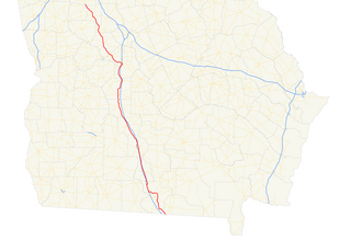
U.S. Route 319 is a spur of U.S. Route 19. It runs for 303 miles (488 km) from the foot of the John Gorrie Memorial Bridge across from downtown Apalachicola, Florida to US 1/SR 4 in Wadley, Georgia, through the Panhandle of Florida and the southern portion of Georgia.
State Route 42 (SR 42) is a 115.3-mile-long (185.6 km) state highway that runs southeast-to-northwest through portions of Peach, Crawford, Monroe, Butts, Henry, Clayton, and DeKalb counties in the central and north-central parts of the U.S. state of Georgia. The route connects Byron with the Atlanta metropolitan area, via McDonough, Stockbridge, and Forest Park.
State Route 54 (SR 54) is a 70.5-mile-long (113.5 km) state highway that runs southwest-to-northeast through portions of Troup, Meriwether, Coweta, Fayette, Clayton, and Fulton counties in the northwestern part of the U.S. state of Georgia. The route connects Hogansville with Atlanta, via Peachtree City, Fayetteville, Jonesboro, and Forest Park.
State Route 2 is a 197-mile-long (317 km) west–to–east state highway in the U.S. state of Tennessee. It begins in Murfreesboro, in Rutherford County, and ends near Farragut in Loudon County.
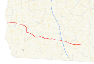
State Route 112 (SR 112) is a 195-mile-long (314 km) state highway that travels in a generally southwest-to-northeast orientation in the southwestern and central parts of the U.S. state of Georgia. It passes through portions of Grady, Mitchell, Worth, Turner, Wilcox, Pulaski, Bleckley, Twiggs, Wilkinson, and Baldwin counties, and connects the Cairo and Milledgeville areas of the state.
State Route 90 (SR 90) is a 155-mile-long (249 km) state highway that runs southeast-to-northwest through portions of Atkinson, Coffee, Irwin, Ben Hill, Turner, Wilcox, Crisp, Dooly, Macon, Taylor, and Talbot counties in the south-central and west-central parts of the U.S. state of Georgia. The route connects Willacoochee and Talbotton, via Fitzgerald and Ocilla.
State Route 30 (SR 30) is a 229.8-mile-long (369.8 km) state highway that travels west-to-east through portions of Marion, Sumter, Crisp, Wilcox, Dodge, Telfair, Wheeler, Montgomery, Toombs, Tattnall, Evans, Bryan, Effingham, and Chatham counties in the south-central part of the U.S. state of Georgia. The highway connects the southern part of Marion County with Port Wentworth, via Americus, Cordele, Abbeville, McRae, Vidalia, Reidsville, Claxton, and Pembroke. The highway is concurrent with U.S. Route 280 (US 280) for about four-fifths of its length, from Americus to Blitchton, which is the eastern-most 183.9 miles (296.0 km) of US 280's length.
State Route 11 (SR 11) is a 376-mile-long (605 km) state highway in the U.S. state of Georgia, traveling through portions of Echols, Lanier, Berrien, Irwin, Ben Hill, Wilcox, Pulaski, Houston, Peach, Bibb, Jones, Jasper, Newton, Walton, Barrow, Jackson, Hall, White, Lumpkin, and Union counties. It travels the entire length of the state from south to north, connecting the Florida state line with the North Carolina state line, roughly bisecting the state into two equal parts. It travels through Warner Robins, Macon, and Gainesville It is the longest route in the state. The portion from the southeastern city limits of Monticello to the Jasper–Newton county line is included in the Monticello Crossroads Scenic Byway.
State Route 31 (SR 31) is a 166.9-mile-long (268.6 km) state highway that travels south-to-north through portions of Lowndes, Lanier, Clinch, Atkinson, Coffee, Telfair, Wheeler, Dodge, Laurens, and Johnson counties in the south-central part of the U.S. state of Georgia. The highway connects the Florida state line, south of Clyattville with Wrightsville, via Valdosta, Douglas, and Dublin.
State Route 32 (SR 32) is a 188.8-mile-long (303.8 km) state highway that travels west-to-east through portions of Terrell, Lee, Worth, Turner, Irwin, Coffee, Bacon, Pierce, Brantley, and Glynn counties in the southern part of the U.S. state of Georgia. The highway connects Dawson with Sterling, via Leesburg, Ashburn, Fitzgerald, Douglas, and Alma.
State Route 37 (SR 37) is a 153.6-mile-long (247.2 km) state highway that travels west-to-east through portions of Clay, Calhoun, Baker, Mitchell, Colquitt, Cook, Berrien, Lanier, and Clinch counties in the southwestern and south-central parts of the U.S. state of Georgia. The highway connects the Alabama state line west of Fort Gaines to the Homerville area, via Newton, Camilla, Moultrie, Adel, and Lakeland.
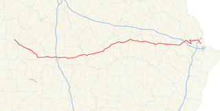
U.S. Route 82 (US 82) is a 232-mile-long (373 km) U.S. Highway in the U.S. state of Georgia. It travels from the Chattahoochee River at Georgetown to its eastern terminus southwest of Brunswick. It travels through such cities as Cuthbert, Dawson, Albany, Sylvester, Tifton, Pearson, Waycross, and Nahunta before reaching its eastern terminus.
U.S. Route 221 (US 221) in the U.S. state of Georgia is a south–north U.S. Highway. It travels from the Florida border near the Quitman area to the South Carolina state line, north of Pollards Corner. The highway connects North Central Florida with Upstate South Carolina.
U.S. Route 129 (US 129) is a 375-mile-long (604 km) U.S. Highway in the U.S. state of Georgia. It travels south-to-north from the Florida state line, south of Statenville, to the North Carolina state line, northwest of Blairsville.
State Route 133 (SR 133) is an 82.8-mile-long (133.3 km) southeast-to-northwest state highway in the southwestern part of the U.S. state of Georgia. It travels through portions of Lowndes, Brooks, Colquitt, Worth, Dougherty, and Lee counties. It connects the Valdosta and Albany areas.
State Route 122 (SR 122) is a 98.2-mile-long (158.0 km) state highway that travels west-to-east through portions of Thomas, Brooks, Lowndes, Lanier, Clinch, and Ware counties in the southern part of the U.S. state of Georgia. The highway connects the cities of Thomasville and Waycross, via Lakeland.
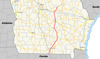
State Route 135 (SR 135) is a 130-mile-long (210 km) state highway in the south-central part of the U.S. state of Georgia. It connects the Florida state line with Higgston, via Lakeland, Willacoochee, Douglas, and Hazlehurst. It travels concurrently with U.S. Route 221 for extensive distances, a short piece in Lakeland and a longer one from Douglas to Uvalda.
Business routes of Interstate 75 exist in three states. Georgia has three existing Interstate 75 (I-75) business routes, and one other that was deleted. Ohio has three business routes for I-75. Nine other I-75 business routes also exist, or have existed, in Michigan, and a 10th has been proposed.
State Route 168 (SR 168) is a state highway that runs west–east through portions of Berrien, Lanier, and Clinch counties in the south-central part of the U.S. state of Georgia.
Route map: Google
KML file (edit • help) |