Interstate 985 (I-985) is a 25.01-mile-long (40.25 km) Auxiliary Interstate Highway in the northeastern part of the U.S. state of Georgia. It links the Atlanta metropolitan area to the city of Gainesville via Suwanee. I-985 is also known as the Sidney Lanier Parkway and is also designated as unsigned State Route 419. The roadway was designated as I-985 in 1985.

State Route 120 (SR 120) is a 90.7-mile-long (146.0 km) state highway that runs west-to-east through portions of Haralson, Paulding, Cobb, Fulton, and Gwinnett counties in northwestern part of the U.S. state of Georgia.

State Route 365 (SR 365) is a 69.5-mile-long (111.8 km) state highway that travels within portions of Gwinnett, Hall, Habersham, and Stephens counties. It begins at exit 113 on Interstate 85 (I-85), at the southeastern edge of Suwanee. This is also the southern terminus of I-985. It continues from that point concurrent with I-985 for the entire length of that freeway. Eventually, U.S. Route 23 (US 23) also joins the concurrency. The highway heads northeast through Gainesville and Toccoa, before it terminates at the South Carolina state line, southwest of Westminster, South Carolina.
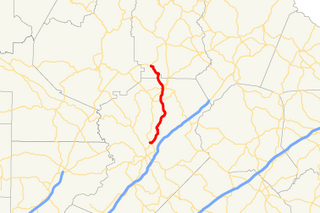
State Route 332 (SR 332) is a 23.2-mile (37.3 km) state highway in the northeastern part of the U.S. state of Georgia. It travels from SR 53 in Hoschton in Jackson County to SR 13 in Oakwood in Hall County. The route physically travels in a backwards "C" shape.

State Route 233 (SR 233) is a 19.4-mile-long (31.2 km) north–south state highway in the central part of the U.S. state of Georgia. It travels through portions of Ben Hill and Wilcox counties.

State Route 8 (SR 8) is a 183-mile-long (295 km) state highway that travels west-to-east through portions of Haralson, Carroll, Douglas, Cobb, Fulton, DeKalb, Gwinnett, Barrow, Clarke, Oconee, Madison, Franklin, and Hart counties, bisecting the northern part of the U.S. state of Georgia. The highway travels from its western terminus at US 78 and SR 4 at the Alabama state line west of Tallapoosa to its eastern terminus at US 29 at the South Carolina state line at the south end of Lake Hartwell. The highway is concurrent with either US 29 or US 78 for its entire length.
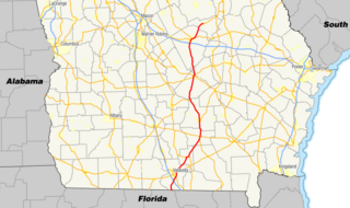
State Route 31 (SR 31) is a 166.9-mile-long (268.6 km) state highway that travels south-to-north through portions of Lowndes, Lanier, Clinch, Atkinson, Coffee, Telfair, Wheeler, Dodge, Laurens, and Johnson counties in the south-central part of the U.S. state of Georgia. The highway connects the Florida state line, south of Clyattville with Wrightsville, via Valdosta, Douglas, and Dublin.

State Route 36 (SR 36) is a 95.2-mile-long (153.2 km) state highway that travels southwest-to-northeast through portions of Harris, Talbot, Upson, Lamar, Butts, and Newton counties in the central part of the U.S. state of Georgia. The highways connects the Waverly Hall area with Covington, via Thomaston, Barnesville, and Jackson.

State Route 43 (SR 43) is a 25.7-mile-long (41.4 km) state highway that travels southwest-to-northeast through portions of McDuffie and Lincoln counties in the east-central part of the U.S. state of Georgia. The highway connects the northern part of the Thomson area to the South Carolina state line, via Lincolnton.
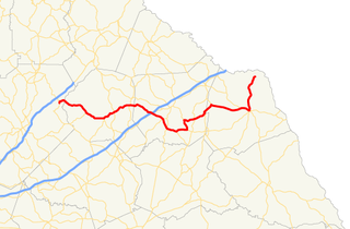
State Route 51 (SR 51) is a 63.6-mile-long (102.4 km) state highway that travels west-to-east through portions of Hall, Banks, Franklin, and Hart counties in the northeastern part of the U.S. state of Georgia. The highway connects Lula with Lake Hartwell, via Homer, Carnesville, and Hartwell.

State Route 271 (SR 271) is a 7.6-mile-long (12.2 km) east–west state highway located in the west-central part of the U.S. state of Georgia. Its route is within Schley and Sumter counties.

State Route 270 (SR 270) is a 12.7-mile-long (20.4 km) east–west state highway located in the southern part of the U.S. state of Georgia. Its route is within Mitchell and Colquitt counties.

State Route 268 (SR 268) is a 22.9-mile-long (36.9 km) southwest–northeast state highway located in the south-central part of the U.S. state of Georgia. It travels within portions of Coffee and Jeff Davis counties.

State Route 262 (SR 262) is a 44.4-mile-long (71.5 km) L-shaped state highway located in the southwestern part of the U.S. state of Georgia. It travels within portions of within Decatur and Mitchell counties, and skims the border of Grady County.

State Route 243 (SR 243) was a 21.2-mile-long (34.1 km) north–south state highway located in the central part of the U.S. state of Georgia. It existed in portions of Wilkinson and Baldwin counties.

State Route 60 (SR 60) is a 90.1-mile-long (145.0 km) state highway that travels southeast-to-northwest through portions of Jackson, Hall, Lumpkin, Union, and Fannin counties in the north-central part of the U.S. state of Georgia. The highway connects the Braselton area with McCaysville at the Tennessee state line, via Gainesville and Dahlonega.

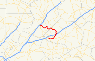
State Route 231 (SR 231) is a 20.6-mile-long (33.2 km) north-south state highway in the central part of the U.S. state of Georgia. It travels entirely within Washington County. It serves as a de facto bypass or alternate route for travelers who desired to bypass Sandersville.

State Route 98 (SR 98) is a 36.6-mile-long (58.9 km) state highway that travels southeast-to-northwest through portions of Madison, Jackson, and Banks counties in the northeastern part of the U.S. state of Georgia. The highway connects Comer and Homer, via Danielsville, Commerce, and Maysville.

State Route 201 (SR 201) is a 20.9-mile-long (33.6 km) state highway in the northwestern part of the U.S. state of Georgia. It travels from Villanow, in Walker County northeast to Varnell, in Whitfield County.

State Route 230 (SR 230) is a 59.2-mile-long (95.3 km) west–east state highway in the central part of the U.S. state of Georgia. It travels in a northern arc through portions of Dooly, Pulaski, and Dodge counties.