Georgia State Route 384

Last updated

Georgia 384.svg

State Route 384
Duncan Bridge Road
Georgia state route 384 map.png
Route information
Maintained by GDOT
Length 15.6 mi [1] (25.1 km)
Existed 1988 [2] [3] – present
Major junctions
South endUS 23.svgGeorgia 365.svg US 23 / SR 365 in Baldwin
North endGeorgia 75.svg SR 75 southeast of Helen
Location
Counties Habersham, White
Highway system
  • Georgia State Routes
Georgia 383.svg SR 383 SR 385 Georgia 385.svg

State Route 384 (SR 384) is a 15.6-mile-long (25.1 km) state highway in the northeast part of the U.S. state of Georgia. It travels southeast-to-northwest along Duncan Bridge Road from US 23/SR 365 in the western part of Baldwin to SR 75 southeast of Helen. The route serves as a gateway to Helen and the North Georgia mountains.

Northeast Georgia

Northeast Georgia is a region of Georgia in the United States. The northern part is also in the north Georgia mountains, while the southern part is still hilly but much flatter in topography. Northeast Georgia is also served by the Asheville/Spartanburg/Greenville/Anderson market.

U.S. state constituent political entity of the United States

In the United States, a state is a constituent political entity, of which there are currently 50. Bound together in a political union, each state holds governmental jurisdiction over a separate and defined geographic territory and shares its sovereignty with the federal government. Due to this shared sovereignty, Americans are citizens both of the federal republic and of the state in which they reside. State citizenship and residency are flexible, and no government approval is required to move between states, except for persons restricted by certain types of court orders. Four states use the term commonwealth rather than state in their full official names.

Georgia (U.S. state) State of the United States of America

Georgia is a state in the Southeastern United States. It began as a British colony in 1733, the last and southernmost of the original Thirteen Colonies to be established. Named after King George II of Great Britain, the Province of Georgia covered the area from South Carolina south to Spanish Florida and west to French Louisiana at the Mississippi River. Georgia was the fourth state to ratify the United States Constitution, on January 2, 1788. In 1802–1804, western Georgia was split to the Mississippi Territory, which later split to form Alabama with part of former West Florida in 1819. Georgia declared its secession from the Union on January 19, 1861, and was one of the original seven Confederate states. It was the last state to be restored to the Union, on July 15, 1870. Georgia is the 24th largest and the 8th most populous of the 50 United States. From 2007 to 2008, 14 of Georgia's counties ranked among the nation's 100 fastest-growing, second only to Texas. Georgia is known as the Peach State and the Empire State of the South. Atlanta, the state's capital and most populous city, has been named a global city. Atlanta's metropolitan area contains about 55% of the population of the entire state.

Contents

Route description

SR 384 begins at an intersection with US 23/SR 365 (Tommy Irwin Parkway) in the western part of Baldwin in southwestern Habersham County. The route heads northwest and crosses the Chattahoochee River into White County. The highway has an intersection with SR 254. Almost immediately, in Leaf, is an intersection with SR 115 (Clarkesville Highway). The route bends to the north-northeast and intersects SR 255 in Stovall Mill. SR 384 curves back to the northwest. It then meets its northern terminus, an intersection with SR 75 (Helen Highway), southeast of Helen.

Intersection (road) A road junction where two or more roads either meet or cross at grade

An intersection is an at-grade junction where two or more roads meet or cross. Intersections may be classified by number of road segments, traffic controls, and/or lane design.

U.S. Route 23 in Georgia highway in Georgia

U.S. Route 23 (US 23) in the U.S. state of Georgia, is a north–south United States highway that travels from the St. Marys River south-southeast of Folkston to the North Carolina state line, in the northern part of Dillard.

Georgia State Route 365 highway in Georgia

State Route 365 (SR 365) is a 69.5-mile-long (111.8 km) state highway that travels within portions of Gwinnett, Hall, Habersham, and Stephens counties. It begins at exit 113 on Interstate 85 (I-85), at the southeastern edge of Suwanee. This is also the southern terminus of I-985. It continues from that point concurrent with I-985 for the entire length of that freeway. Eventually, U.S. Route 23 (US 23) also joins the concurrency. The highway heads northeast through Gainesville and Toccoa, before it terminates at the South Carolina state line, southwest of Westminster, South Carolina.

SR 384 is not part of the National Highway System, a system of roadways important to the nation's economy, defense, and mobility. [4]

National Highway System (United States) highway system in the United States

The National Highway System (NHS) is a network of strategic highways within the United States, including the Interstate Highway System and other roads serving major airports, ports, rail or truck terminals, railway stations, pipeline terminals and other strategic transport facilities. Altogether, it constitutes the largest highway system in the world.

History

The roadway that would eventually become SR 384 was established between 1963 and 1966 on an alignment from Alto to Leaf. [5] [6] In 1971, that roadway was extended along the path of current SR 384 to the intersection with SR 75. [7] [8] By March 1980, the southern terminus was shifted to the current location in Baldwin. [9] [10] In 1988, the entire roadway was designated as SR 384. [2] [3]

Alto, Georgia Town in Georgia, United States

Alto is a town in Banks and Habersham counties in the U.S. state of Georgia. As of the 2010 census, the town had a population of 1,172, up from 876 at the 2000 census.

Major intersections

CountyLocationmi [1] kmDestinationsNotes
Habersham Baldwin 0.00.0US 23.svgGeorgia 365.svg US 23 / SR 365 (Tommy Irwin Parkway)Southern terminus
Chattahoochee River 4.26.8Unnamed bridge; crossing over the Chattahoochee River, marking the Habersham–White county line
White 6.911.1Georgia 254.svg SR 254  Clermont
Leaf 7.612.2Georgia 115.svg SR 115 (Clarkesville Highway) Cleveland, Clarkesville
Stovall Mill 10.717.2Georgia 255.svg SR 255  Cleveland, Clarkesville
15.625.1Georgia 75.svg SR 75 (Helen Highway) Cleveland, Helen, Hiawassee Northern terminus
1.000 mi = 1.609 km; 1.000 km = 0.621 mi

See also

Related Research Articles

Georgia State Route 6 highway in Georgia

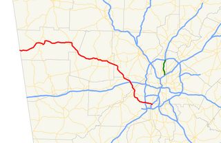
State Route 6 (SR 6) is a 72.1-mile-long (116.0 km) state highway that travels northwest-to-southeast in the U.S. state of Georgia. It is known as Jimmy Lee Smith Parkway, Jimmy Campbell Parkway, Nathan Dean Parkway, and Wendy Bagwell Parkway in Paulding County; C.H. James Parkway in Cobb County; Thornton Road in Douglas County; and Camp Creek Parkway and honorarily as Tuskegee Airmen Parkway in Fulton and Clayton counties. It begins at the Alabama state line, where it is concurrent with US 278. Here, US 278 enters Alabama, concurrent with the unsigned state highway SR 74. Its eastern terminus is at an interchange with Interstate 85 (I-85) west of the Hartsfield–Jackson Atlanta International Airport.

Georgia State Route 13 highway in Georgia

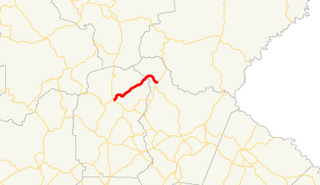
State Route 13 (SR 13) is a 49.5-mile-long (79.7 km) state highway in the north-central part of the U.S. state of Georgia, that travels through portions of Fulton, DeKalb, Gwinnett, and Hall counties.

Georgia State Route 14 highway in Georgia

State Route 14 (SR 14) is a 87.4-mile-long (140.7 km) state highway that travels southwest-to-northeast through portions of Troup, Coweta, and Fulton counties in the west-central and north-central parts of the U.S. state of Georgia. The highway connects the Alabama state line in West Point to Downtown Atlanta, via LaGrange, Fairburn, College Park, and East Point. Except for the northernmost segment, it is entirely concurrent with U.S. Route 29 (US 29).

Georgia State Route 15 highway in Georgia

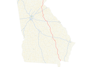
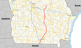
State Route 15 (SR 15) is a 346-mile-long (557 km) state highway that travels south-to-north across the entire length of the U.S. state of Georgia, east of its centerline. It connects the Florida state line, south-southeast of Folkston with the North Carolina state line, in Dillard, via Folkston, Vidalia, Sandersville, Athens, Demorest, and Clayton.

Georgia State Route 374 highway in Georgia

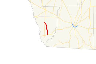
State Route 374 (SR 374) is a 7.9-mile-long (12.7 km) rural state highway located entirely in Seminole County in the southwestern part of the U.S. state of Georgia. The roadway was built in the early 1960s and was designated as SR 374 in 1972.

Georgia State Route 378 highway in Georgia

State Route 378 (SR 378) is a 6.4-mile-long (10.3 km), four-lane state highway that travels west-to-east entirely within Gwinnett County in the north-central part of the U.S. state of Georgia. The route is heavily commercialized with numerous office and industrial parks. It is known along its entire length as Beaver Ruin Road. The roadway was built in the mid-1960s and designated a decade later.

Georgia State Route 380 highway in Georgia

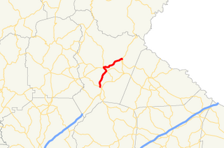
State Route 380 (SR 380) is a 5.8-mile-long (9.3 km) state highway that travels west-to-east in a southern arc entirely within Jasper County in the central part of the U.S. state of Georgia. The highway acts as a partial bypass of Monticello.

Georgia State Route 385 highway in Georgia

State Route 385 (SR 385) is a 11.5-mile-long (18.5 km) southwest–to–northeast state highway that travels from Cornelia to Hollywood in the U.S. state of Georgia. The route is entirely within Habersham County. This highway travels concurrently with U.S. Route 441 Business from Cornelia to Clarkesville. The entire route travels along the historic route of US 441.

Georgia State Route 388 highway in Georgia

State Route 388 (SR 388) is a 4.5-mile-long (7.2 km) state highway that travels south-to-north in a backward L-shape, completely within Columbia County, in the east-central part of the state of Georgia. It connects Grovetown to Lewiston.

Georgia State Route 356 highway in Georgia

State Route 356 (SR 356) is a 10.8-mile-long (17.4 km) east–west state highway located in the northeast part of the U.S. state of Georgia. Its routing is located within portions of White and Habersham counties. Virtually the entire route is contained within the Chattahoochee-Oconee National Forest.

Georgia State Route 28 highway in Georgia

State Route 28 (SR 28) is a 25.7-mile-long (41.4 km) state highway in the U.S. state of Georgia. It exists in two distinct segments separated by the northern segment of South Carolina Highway 28 (SC 28), which connects the two segments. The northern segment is located in the northeastern corner of the Chattooga River District of the Chattahoochee-Oconee National Forest. The southern segment is entirely within the Augusta metropolitan area. SR 28 consists of Georgia's segments of a multi-state Route 28 that includes one segment of North Carolina Highway 28 (NC 28) and two segments of SC 28. The northern segment of SR 28 is unnamed, but the southern segment is known as Furys Ferry Road from its western terminus to the intersection with SR 104 Conn. in Augusta, Washington Road in the northern part of Augusta, John C. Calhoun Expressway, Greene Street, 5th Street, and Broad Street in downtown Augusta, and Sand Bar Ferry Road in the northeastern part of Augusta.

Georgia State Route 17 highway in Georgia

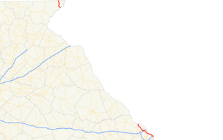
State Route 17 (SR 17) is a 294-mile-long (473 km) state highway that travels south-to-north through portions of Chatham, Effingham, Screven, Jenkins, Burke, Jefferson, Warren, McDuffie, Wilkes, Elbert, Hart, Franklin, Stephens, Habersham, White, and Towns counties in the east-central and northeastern parts of the U.S. state of Georgia. The highway connects Interstate 16 (I-16) in Bloomingdale to the North Carolina state line, northwest of Hiawassee, via Millen, Louisville, Wrens, Thomson, Washington, Elberton, Royston, Toccoa, Clarkesville, and Hiawassee.

Georgia State Route 21 highway in Georgia

State Route 21 (SR 21) is an 84.4-mile-long (135.8 km) state highway that travels southeast-to-northwest through portions of Chatham, Effingham, Screven, and Jenkins counties in the eastern part of the U.S. state of Georgia. The highway connects the Savannah and Millen areas, via Garden City, Port Wentworth, Rincon, Springfield, and Sylvania.

Georgia State Route 22 highway in Georgia

State Route 22 (SR 22) is a 221.1-mile-long (355.8 km) state highway that travels southwest-to-northeast in an eastern arc through portions of Muscogee, Talbot, Taylor, Upson, Crawford, Bibb, Jones, Baldwin, Hancock, Taliaferro, Oglethorpe, and Madison counties in the western and west-central parts of the U.S. state of Georgia. The highway connects the Alabama state line in Columbus, across the state line from Phenix City, Alabama, to Comer, via Macon and Milledgeville.

Georgia State Route 29 highway in Georgia

State Route 29 (SR 29) is a 98.1-mile-long (157.9 km) state highway that travels southeast-to-northwest through portions of Toombs, Montgomery, Treutlen, Laurens, Wilkinson, and Baldwin counties in the central part of the U.S. state of Georgia. The highway connects the Vidalia area with the Milledgeville area, via the Dublin area.

Georgia State Route 31 highway in Georgia

State Route 31 (SR 31) is a 166.9-mile-long (268.6 km) state highway that travels south-to-north through portions of Lowndes, Lanier, Clinch, Atkinson, Coffee, Telfair, Wheeler, Dodge, Laurens, and Johnson counties in the south-central part of the U.S. state of Georgia. The highway connects the Florida state line, south of Clyattville with Wrightsville, via Valdosta, Douglas, and Dublin.

Georgia State Route 60 highway in Georgia

State Route 60 (SR 60) is a 90.1-mile-long (145.0 km) state highway that travels southeast-to-northwest through portions of Jackson, Hall, Lumpkin, Union, and Fannin counties in the north-central part of the U.S. state of Georgia. The highway connects the Braselton area with McCaysville at the Tennessee state line, via Gainesville and Dahlonega.

U.S. Route 25 in Georgia highway in Georgia, United States

U.S. Route 25 (US 25) is a U.S. Highway that travels from Brunswick, Georgia to the Kentucky-Ohio state line, where Covington, Kentucky meets Cincinnati, Ohio at the Ohio River. In the U.S. state of Georgia, US 25 is as a 190.0-mile-long (305.8 km) highway that travels south to north in the eastern part of the state, near the Atlantic Ocean, serving Brunswick, Statesboro, and Augusta on its path from Brunswick to South Carolina at the Savannah River. Its routing travels through portions of Glynn, Wayne, Long, Tattnall, Evans, Bulloch, Jenkins, Burke, and Richmond counties.

There are at least thirteen current and three former special routes of U.S. Route 27.

References

  1. 1 2 Google (September 14, 2013). "Route of SR 384" (Map). Google Maps . Google. Retrieved September 14, 2013.
  2. 1 2 Georgia State Highway System (PDF) (Map). Cartography by GSHD. Georgia State Highway Department. January 1, 1988. Retrieved August 13, 2015.
  3. 1 2 Georgia State Highway System (PDF) (Map). Cartography by GSHD. Georgia State Highway Department. January 1, 1989. Retrieved August 13, 2015.
  4. "National Highway System: Georgia" (PDF). Federal Highway Administration. October 1, 2012. Retrieved September 15, 2013.
  5. Georgia State Highway System (PDF) (Map). Cartography by GSHD. Georgia State Highway Department. June 1, 1963. Retrieved August 13, 2015.
  6. Georgia State Highway System (PDF) (Map). Cartography by GSHD. Georgia State Highway Department. January 1, 1966. Retrieved August 13, 2015.
  7. Georgia State Highway System (PDF) (Map). Cartography by GSHD. Georgia State Highway Department. January 1, 1971. Retrieved August 13, 2015.
  8. Georgia State Highway System (PDF) (Map). Cartography by GSHD. Georgia State Highway Department. January 1, 1972. Retrieved August 13, 2015.
  9. Georgia State Highway System (PDF) (Map). Cartography by GSHD. Georgia State Highway Department. January 1, 1979. Retrieved August 13, 2015.
  10. Georgia State Highway System (PDF) (Map). Cartography by GSHD. Georgia State Highway Department. March 1, 1980. Retrieved August 13, 2015.

Route map: Google

KML file (edithelp)
KML is from Wikidata