
Crete is the largest and most populous of the Greek islands, the 88th largest island in the world and the fifth largest island in the Mediterranean Sea, after Sicily, Sardinia, Cyprus, and Corsica. Crete rests approximately 160 km (99 mi) south of the Greek mainland. It has an area of 8,336 km2 (3,219 sq mi) and a coastline of 1,046 km (650 mi). It bounds the southern border of the Aegean Sea, with the Sea of Crete to the north and the Libyan Sea to the south.

Heraklion or Iraklion is the largest city and the administrative capital of the island of Crete and capital of Heraklion regional unit. It is the fifth largest city in Greece with a population of 211,370 according to the 2011 census. The population of the municipality was 173,993.

The history of Crete goes back to the 7th millennium BC, preceding the ancient Minoan civilization by more than four millennia. The palace-based Minoan civilization was the first civilization in Europe.
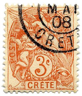
The French post offices in Crete were among a collection of post offices maintained by foreign countries during the late 1800s/early 1900s, after Crete had broken away from the Ottoman Empire, and until 1914 after Crete united with Greece in 1913. The offices were in [[Chania] LA CANEE Rethymnon RETHYMNO Heraklion CANDIE Sitia SITIA Ierapetra HIERAPETRA and Agios Nikolaos SAN NICOLO; the last three were already closed end of 1899
Platanias is a village and municipality on the Greek island of Crete. It is located about 10 km (6.2 mi) west from the city of Chania and east of Kissamos, on Chania Bay. The seat of the municipality is the village Gerani. Platanias is a popular tourism village with beaches, several hotels, restaurants, bars, nightclubs and souvenir shops. The area is especially popular with Scandinavian tourists with the season running from April to October. Not far from the coast is the island of Agioi Theodoroi.
ANEK Lines is one of the largest passenger shipping companies in Greece. It was founded in 1967 by numerous shareholders who were inhabitants of Crete. It operates passenger ferries, mainly on Piraeus-Crete and Adriatic Sea lines.

Rethymno is a city in Greece on the island of Crete. It is the capital of Rethymno regional unit, and has a population of more than 30,000 inhabitants. It is a former Latin Catholic bishopric as Retimo(–Ario) and former Latin titular see.

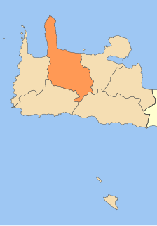
The Municipality of Rethymno is a municipality in the Rethymno of the region of Crete established by Kallikratis reform. It consists of the unification of the pre-existing municipalities Arkadi, Lappa, Rethymno and Nikiforos Fokas of Rethymno Prefecture. The extent of the new municipality is 396.256 km2 (152.995 sq mi), and it had a population of 55,525 inhabitants at the 2011 census. The seat of the new municipality is the town Rethymno.

Chromonastiri is a local community of the Rethymno Municipality in the Rethymno of the region of Crete established by Kallikratis reform. Previously, it was part of the former municipality of Rethymno. Chromonastiri is a traditional settlement and is classified in Class II, that is of average cultural value. Buildings with Venetian architectural elements are scattered throughout the village. In the years 2005, 2007, 2008 and 2009 Chromonastiri received an award of the '"cleaner and organized traditional community"'
Roustika is a local community of the Rethymno Municipality in the Rethymno of the region of Crete established by Kallikratis reform. Previously, it was part of municipality of Nikiforos Fokas. Capital of the new municipality is Rethymnon. It is traditional settlement and is classified in Class II, that is of average cultural value. In 2005 Roustika was awarded as a "'clean and organized traditional community"'
Maroulas is a local community of the Rethymno Municipality in the Rethymno of the region of Crete established by Kallikratis reform. It is traditional settlement and is classified in Class II, that is of average cultural value.
Roussospiti is a local community of the Rethymno Municipality in the Rethymno of the region of Crete established by Kallikratis reform. Previously, it was part of the former municipality of Rethymno. It is a traditional settlement and is classified in Class II, that is of average cultural value.
Amnatos is a local community of the Rethymno Municipality in the Rethymno of the region of Crete established by Kallikratis reform. Previously, it was part of the municipal district of Municipality of Arkadi. Amnatos is a traditional settlement and is classified in Class II, that is of "average cultural value". Buildings with Venetian architectural elements are scattered throughout the village. In 2005 Amnatos received an award of the "cleaner and organized traditional community".

Atsipopoulo is a local community of the Rethymno Municipality in the Rethymno of the region of Crete established by Kallikratis reform. Previously, it was part of municipality of Nikiforos Fokas. Capital of the new municipality is Rethymno.
Pigi is a local community of the Rethymno Municipality in the Rethymno regional unit of the region of Crete established by Kallikratis reform. Previously, it was part of the municipal district of Municipality of Arkadi. Capital of the new municipality is Rethymno.
Myriokefala is a local community of the Rethymno Municipality in the Rethymno of the region of Crete established by Kallikratis reform. Previously, it was part of municipality of Lappa. Capital of the new municipality is Rethymno.
Μyli is a part of the local community of Chromonastiri of the Rethymno Municipality in the Rethymno of the region of Crete established by Kallikratis reform. Capital of the new municipality is Rethymno.
Agia Galini is a village in Rethymno regional unit, Crete, Greece.
Elizabeth A. Zachariadou was a Greek scholar on Turkish studies, specializing on the early Ottoman Empire.
