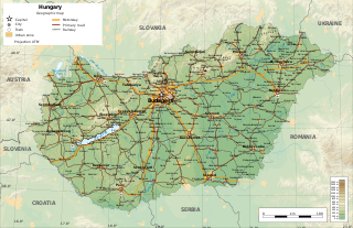
Hungary is a landlocked country in the southeastern region of Central Europe, bordering the Balkans. Situated in the Carpathian Basin, it has a land area of 93,030 square km, measuring about 250 km from north to south and 524 km from east to west. It has 2,106 km of boundaries, shared with Slovakia to the north, Ukraine to the northeast, Romania to the east and southeast, Serbia to the south, Croatia to the southwest, Slovenia to the west and southwest, and Austria to the west.

The Tisza, Tysa or Tisa, is one of the major rivers of Central and Eastern Europe. It was once called "the most Hungarian river" because it flowed entirely within the Kingdom of Hungary. Today, it crosses several national borders.

Kaposvár is a city with county rights in the southwestern part of Hungary, south of Lake Balaton. It is one of the leading cities of Transdanubia, the capital of Somogy County, and the seat of the Kaposvár District and the Roman Catholic Diocese of Kaposvár.

The Caucasus Mountains are a mountain range at the intersection of Asia and Europe. Stretching between the Black Sea and the Caspian Sea, they are surrounded by the Caucasus region and are home to Mount Elbrus, the highest peak in Europe at 5,642 metres (18,510 ft) above sea level.

Tatabánya is a city with county rights of 64,305 inhabitants in northwestern Hungary, in the Central Transdanubian region. It is the capital of Komárom-Esztergom County.
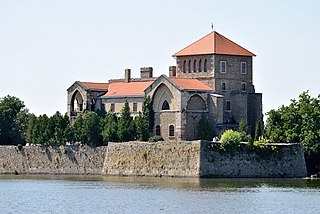
Tata is a town in Komárom-Esztergom County, northwestern Hungary, 9 km (6 mi) northwest of the county town Tatabánya.

The Pannonian Basin, or Carpathian Basin, is a large sedimentary basin situated in south-east Central Europe. The geomorphological term Pannonian Plain is more widely used for roughly the same region though with a somewhat different sense, with only the lowlands, the plain that remained when the Pliocene Epoch Pannonian Sea dried out.

The Bükk Mountains are a section of the North Hungarian Mountains of the Inner Western Carpathians. Much of the area is included in the Bükk National Park.

The Little Hungarian Plain or Little Alföld is a plain of approximately 8,000 km² in northwestern Hungary, south-western Slovakia, and eastern Austria. It is a part of the Pannonian plain which covers most parts of Hungary.

Keszthely is a Hungarian city of 20,895 inhabitants located on the western shore of Lake Balaton. It is the second largest city by the lake and one of the more important cultural, educational and economic hubs in the region. Due to its favorable location and accessibility by both road and rail, Keszthely and the surrounding area is a preferred holiday destination.

The Transdanubian Mountains are a mountain range in Hungary covering about 7000 km2. Its highest peak is the Pilis, with a height of 757 m (2,484 ft).
The North Hungarian Mountains, sometimes also referred to as the Northeast Hungarian Mountains, Northeast Mountains, North Hungarian Highlands, North Hungarian Mid-Mountains or North Hungarian Range, is the northern, mountainous part of Hungary. It forms a geographical unity with the Mátra-Slanec Area, the adjacent parts of Slovakia. It is a separate geomorphological area within the Western Carpathians.

The Pannonian island mountains is a term for isolated mountains scattered across the Pannonian Plain, chiefly its western and southern parts, in Hungary, Serbia and Croatia. In prehistoric times, these mountains were islands of the ancient Pannonian Sea that disappeared about 600,000 years ago.

Pilis Mountains is a mountainous region in the Transdanubian Mountains. Its highest peak is Pilis-tető at 756 meters (2,480 ft). It is a popular hiking destination in Hungary.

The climate of Hungary is characterized by its position. Hungary is in the eastern part of Central Europe, roughly equidistant from the Equator and the North Pole, more than 1,000 kilometres (600 mi) from either and about 1,000 kilometers from the Atlantic Ocean.

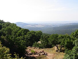
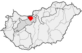
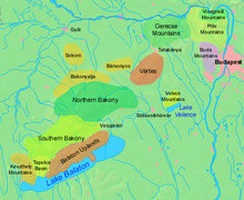
Vértes is a mountain range in north-western Hungary, in the Central Transdanubian region, between the ranges Bakony and Gerecse. The Vértes Mountains are part of the Transdanubian Mountains.

The North Central Rockies forests is a temperate coniferous forest ecoregion of Canada and the United States. This region overlaps in large part with the North American inland temperate rainforest and gets more rain on average than the South Central Rockies forests and is notable for containing the only inland populations of many species from the Pacific coast.
This list, 2013 in molluscan paleontology, is a list of new taxa of ammonites and other fossil cephalopods, as well as fossil gastropods, bivalves and other molluscs that have been described during the year 2013.
The Visegrád Mountains is a mountain range in Hungary, northwest of Budapest.

Dunazug Mountains is a part of Transdanubian Mountains in Hungary. It is the easternmost part of the mountains that connects it to the Danube Bend and the capital. The name itself also comes from the river, while zug means recess, corner.