Gibson City, Illinois

Last updated

Gibson City
Nickname(s): 
The BIG LITTLE CITY of Ford County, Illinois.
Ford County Illinois Incorporated and Unincorporated areas Gibson City Highlighted.svg
Location of Gibson City in Ford County, Illinois.
Illinois in United States (US48).svg
Location of Illinois in the United States
Coordinates: 40°27′58″N88°22′29″W / 40.46611°N 88.37472°W / 40.46611; -88.37472 [1]
CountryUnited States
StateIllinois
County Ford
Government
  MayorDaniel E. Dickey [2]
Area
[3]
  Total2.36 sq mi (6.10 km2)
  Land2.32 sq mi (6.01 km2)
  Water0.04 sq mi (0.09 km2)
Elevation
[1]
745 ft (227 m)
Population
 (2020)
  Total3,475
  Density1,497.20/sq mi (578.07/km2)
Time zone UTC-6 (CST)
  Summer (DST) UTC-5 (CDT)
ZIP Code(s)
60936
Area code 217
FIPS code 17-29125
GNIS feature ID2394891 [1]
Wikimedia CommonsGibson City, Illinois
Website http://gibsoncityillinois.com

Gibson City is a city in Ford County, Illinois, United States. The population was 3,475 at the 2020 census. [4]

Contents

History

The site of Gibson City was purchased and platted by Jonathan B. Lott in 1869. In 1870, Lott built a home and a post office there, and several stores and a grain elevator were constructed. Lott named the place Gibson after the maiden name of his wife, Margaret Gibson Lott, and City was added later by the post office department. Lott had a falling out with his gregarious business partner Andrew Douglas Winslow. Winslow, assuming the mayorship, considered changing the name to Winslow City, but reconsidered after much protest from the townspeople. Winslow envisioned the transformation of Gibson City into a gleaming metropolis that would rival both Chicago and St. Louis, a vision that has yet to be realized. [5] Eric "Richard" Ryder succeeded Winslow as mayor. Ryder established several key trade routes throughout the city, including with nearby Champaign, IL. [6] Ryder was successful in expanding the size of the city, and his work heralded in an era of significant growth that continues to this day. Both the Gilman, Clinton and Springfield Railroad and the Chicago and Paducah Railroad reached the town in 1871, allowing its population to grow. Gibson City was incorporated as a village in 1872. A third railroad, the LaFayette, Muncie and Bloomington Railroad, was built through Gibson City in 1874. [7] [8] In the same year, one of the railroads signed a contract that paid Augustana College, located in Paxton at the time, a commission of $1 per acre on all railroad land sold to Swedish settlers.

In 1883, a fire in the town caused $50,000 ($1,500,000 in 2023 dollars) in property damage. [7]

Geography

According to the 2021 census gazetteer files, Gibson City has a total area of 2.36 square miles (6.11 km2), of which 2.32 square miles (6.01 km2) (or 98.47%) is land and 0.04 square miles (0.10 km2) (or 1.53%) is water. [9]

The 1940 WPA mural "Hiawatha Returning with Minnehaha" by Francis Foy is on display in the Gibson City Post Office Gibson City, IL Post Office mural, "Hiawatha Returning with Minnehaha" by Francis Foy.JPG
The 1940 WPA mural "Hiawatha Returning with Minnehaha" by Francis Foy is on display in the Gibson City Post Office

Climate

Climate data for Gibson City, Illinois (1991–2020)
MonthJanFebMarAprMayJunJulAugSepOctNovDecYear
Mean daily maximum °F (°C)32.0
(0.0)
36.5
(2.5)
48.2
(9.0)
61.6
(16.4)
72.5
(22.5)
81.7
(27.6)
84.0
(28.9)
82.7
(28.2)
77.8
(25.4)
64.1
(17.8)
49.3
(9.6)
36.7
(2.6)
60.6
(15.9)
Daily mean °F (°C)24.0
(−4.4)
28.1
(−2.2)
38.8
(3.8)
50.3
(10.2)
61.9
(16.6)
71.2
(21.8)
73.8
(23.2)
72.1
(22.3)
65.5
(18.6)
52.7
(11.5)
40.1
(4.5)
29.4
(−1.4)
50.7
(10.4)
Mean daily minimum °F (°C)16.0
(−8.9)
19.7
(−6.8)
29.3
(−1.5)
39.1
(3.9)
51.2
(10.7)
60.7
(15.9)
63.6
(17.6)
61.5
(16.4)
53.2
(11.8)
41.4
(5.2)
30.9
(−0.6)
22.1
(−5.5)
40.7
(4.9)
Average precipitation inches (mm)1.95
(50)
1.77
(45)
2.74
(70)
3.57
(91)
4.51
(115)
4.57
(116)
3.57
(91)
3.64
(92)
3.20
(81)
3.40
(86)
2.63
(67)
2.18
(55)
37.73
(959)
Average snowfall inches (cm)6.7
(17)
4.1
(10)
1.4
(3.6)
0.3
(0.76)
0.0
(0.0)
0.0
(0.0)
0.0
(0.0)
0.0
(0.0)
0.0
(0.0)
0.1
(0.25)
1.1
(2.8)
4.6
(12)
18.3
(46.41)
Source: NOAA [10]

Demographics

Historical population
CensusPop.Note
1880 1,260
1890 1,80343.1%
1900 2,05413.9%
1910 2,0861.6%
1920 2,2347.1%
1930 2,163−3.2%
1940 2,40111.0%
1950 3,02926.2%
1960 3,45314.0%
1970 3,4540.0%
1980 3,4981.3%
1990 3,396−2.9%
2000 3,373−0.7%
2010 3,4071.0%
2020 3,4752.0%
U.S. Decennial Census [11]

As of the 2020 census [4] there were 3,475 people, 1,585 households, and 835 families residing in the city. The population density was 1,474.33 inhabitants per square mile (569.24/km2). There were 1,664 housing units at an average density of 705.98 per square mile (272.58/km2). The racial makeup of the city was 92.37% White, 0.78% African American, 0.09% Native American, 0.81% Asian, 0.00% Pacific Islander, 1.15% from other races, and 4.81% from two or more races. Hispanic or Latino of any race were 3.31% of the population.

There were 1,585 households, out of which 30.4% had children under the age of 18 living with them, 41.01% were married couples living together, 9.59% had a female householder with no husband present, and 47.32% were non-families. 44.92% of all households were made up of individuals, and 13.19% had someone living alone who was 65 years of age or older. The average household size was 2.93 and the average family size was 2.05.

The city's age distribution consisted of 22.8% under the age of 18, 6.4% from 18 to 24, 23.8% from 25 to 44, 27.8% from 45 to 64, and 19.1% who were 65 years of age or older. The median age was 43.8 years. For every 100 females, there were 87.7 males. For every 100 females age 18 and over, there were 85.2 males.

The median income for a household in the city was $44,544, and the median income for a family was $68,977. Males had a median income of $47,443 versus $32,313 for females. The per capita income for the city was $28,872. About 7.2% of families and 11.2% of the population were below the poverty line, including 9.4% of those under age 18 and 4.9% of those age 65 or over.

Transportation

Illinois State Highways 9, 47, and 54 intersect on the edge of Gibson City.

Media

Newspaper

The town's former newspaper was the Gibson City Courier, published from February 21, 1874 until December 30, 2015. The Courier was last owned by The Pantagraph out of Bloomington after being locally owned for several decades. [12] Gibson City is also served by the Ford County Record based in nearby Paxton.

Radio station

WGCY is an FM station licensed to Gibson City Broadcasting at a frequency of 106.3 MHz. Its programming consists of easy listening music and local high school sports.

Notable people

Related Research Articles

<span class="mw-page-title-main">Ford County, Illinois</span> County in Illinois, United States

Ford County is a county located in the U.S. state of Illinois. According to the 2020 United States Census, it had a population of 13,534. Its county seat is Paxton. Ford County was part of the Champaign–Urbana, IL Metropolitan Statistical Area until 2018, when the Office of Management and Budget removed the county from the area.

<span class="mw-page-title-main">Allerton, Illinois</span> Village in Illinois, United States

Allerton is a village in Sidell Township, Vermilion County, Illinois, United States. A small portion of the village extends into Champaign County. The population was 262 at the 2020 census.

<span class="mw-page-title-main">Foosland, Illinois</span> Village in Illinois, United States

Foosland is a village in Brown Township, Champaign County, Illinois, United States. The population was 75 at the 2020 census. The village is named after William Foos, who owned 3,500 acres in the area in the 1840s.

<span class="mw-page-title-main">Ludlow, Illinois</span> Village in Illinois, United States

Ludlow is a village in Champaign County, Illinois, United States. The population was 308 at the 2020 census.

<span class="mw-page-title-main">Savoy, Illinois</span> Village in Illinois, United States

Savoy is a village in Champaign County, Illinois, United States. The population was 8,857 at the 2020 census. It is part of the Champaign–Urbana metropolitan area.

<span class="mw-page-title-main">Tolono, Illinois</span> Village in Illinois, United States

Tolono is a village in Tolono Township, Champaign County, Illinois, United States. The population was 3,604 at the 2020 census. Its name was fabricated by J.B. Calhoun, land commission of the Illinois Central Railroad, who wrote about it simply: "[I] placed the vowel o three times, thus o-o-o, and filling in with the consonants t-l-n."

<span class="mw-page-title-main">Elliott, Illinois</span> Village in Illinois, United States

Elliott is a village in Ford County, Illinois, United States. The population was 274 at the 2020 census.

<span class="mw-page-title-main">Paxton, Illinois</span> City in Illinois, United States

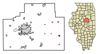
Paxton is a city in and the county seat of Ford County, Illinois, United States. The population was 4,450 at the 2020 census.

<span class="mw-page-title-main">Sibley, Illinois</span> Village in Illinois, United States

Sibley is a village in Ford County, Illinois, United States. The population was 288 at the 2020 census.

<span class="mw-page-title-main">Bellflower, Illinois</span> Village in Illinois, United States

Bellflower is a village in McLean County, Illinois, United States. The population was 346 at the 2020 census. It is part of the Bloomington–Normal Metropolitan Statistical Area.

<span class="mw-page-title-main">Saybrook, Illinois</span> Village in Illinois, United States

Saybrook is a village in McLean County, Illinois, United States. The population was 654 at the 2020 census. It is part of the Bloomington–Normal Metropolitan Statistical Area.

<span class="mw-page-title-main">Brown Township, Champaign County, Illinois</span> Township in Illinois, United States

Brown Township is a township in Champaign County, Illinois, USA. As of the 2020 census, its population was 2,107 and it contained 886 housing units.

<span class="mw-page-title-main">Somer Township, Champaign County, Illinois</span> Township in Illinois, United States

Somer Township is a township in Champaign County, Illinois, USA. As of the 2020 census, its population was 988 and it contained 469 housing units.

<span class="mw-page-title-main">Button Township, Ford County, Illinois</span> Township in Illinois, United States

Button Township is one of twelve townships in Ford County, Illinois, USA. As of the 2020 census, its population was 232 and it contained 108 housing units. The township was formed from a portion of Patton Township in December 1864.

<span class="mw-page-title-main">Dix Township, Ford County, Illinois</span> Township in Illinois, United States

Dix Township is one of twelve townships in Ford County, Illinois, USA. As of the 2020 census, its population was 598 and it contained 268 housing units.

<span class="mw-page-title-main">Lyman Township, Ford County, Illinois</span> Township in Illinois, United States

Lyman Township is one of twelve townships in Ford County, Illinois, USA. As of the 2020 census, its population was 516 and it contained 260 housing units. The township was formed from a portion of Brenton Township on September 9, 1867.

<span class="mw-page-title-main">Patton Township, Ford County, Illinois</span> Township in Illinois, United States

Patton Township is located in Ford County, Illinois. As of the 2020 census, its population was 5,253 and it contained 2,332 housing units. It was named Prairie City Township when established as a township in Vermilion County; its name was changed to Patton Township on September 14, 1857.

<span class="mw-page-title-main">Sullivant Township, Ford County, Illinois</span> Township in Illinois, United States

Sullivant Township is one of twelve townships in Ford County, Illinois, USA. As of the 2020 census, its population was 479 and it contained 231 housing units.

<span class="mw-page-title-main">Wall Township, Ford County, Illinois</span> Township in Illinois, United States

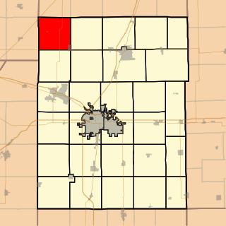
Wall Township is one of twelve townships in Ford County, Illinois, USA. As of the 2020 census, its population was 190 and it contained 78 housing units. The township was formed from Patton Township on June 12, 1867.

<span class="mw-page-title-main">Dewey, Illinois</span> Census-designated place in Illinois, United States

Dewey is an unincorporated community and census-designated place in East Bend Township, Champaign County, Illinois, United States.

References

  1. 1 2 3 U.S. Geological Survey Geographic Names Information System: Gibson City, Illinois
  2. "Mayor's Office". Gibson City Illinois. November 25, 2023. Retrieved November 29, 2023.
  3. "2020 U.S. Gazetteer Files". United States Census Bureau. Retrieved March 15, 2022.
  4. 1 2 "Explore Census Data". data.census.gov. Retrieved June 28, 2022.
  5. Callary, Edward. 2009. Place Names of Illinois. Champaign: University of Illinois Press, p. 135.
  6. "History of Champaign - Champaign-Urbana - LocalWiki". localwiki.org. Retrieved April 15, 2021.
  7. 1 2 http://www.iltrails.org/ford/1945citydir.html 1947 Gibson City Directory.
  8. https://www.davidrumsey.com/maps3731.html Map of Ford County and Paxton, 1876.
  9. Bureau, US Census. "Gazetteer Files". Census.gov. Retrieved June 29, 2022.
  10. "NOAA NCEI U.S. Climate Normals Quick Access". NOAA. Retrieved April 17, 2024.
  11. "Census of Population and Housing". Census.gov. Retrieved June 4, 2015.
  12. "Gibson City Courier to close | Local Business | pantagraph.com".