Girdwood, Anchorage, Alaska

Last updated

The valley, as viewed from Mount Alyeska. The Alyeska Highway can be seen at right running across the valley. Girdwood Valley.jpg
The valley, as viewed from Mount Alyeska. The Alyeska Highway can be seen at right running across the valley.

Girdwood is a resort town within the southern extent of the Municipality of Anchorage in the U.S. state of Alaska. Located near the end of the Turnagain Arm of Cook Inlet, Girdwood lies in a valley in the southwestern Chugach Mountains, surrounded by seven glaciers feeding into a number of creeks, which either converge within the valley or empty directly into the arm. Girdwood is typically accessed by the Seward Highway (Milepost 90), with the main line of the Alaska Railroad paralleling the highway. By road distance, most of the community lies within 35 to 40 miles (56 to 64 km) of Downtown Anchorage. The 2019 American Community Survey estimates a population of 1,742 in the valley. [1]

Contents

Founded as a community to supply miners during the Turnagain Arm gold rushes of the 1890s, Girdwood was mostly a small, quiet place until the middle of the 20th century. Two events drastically altered that. The first was the establishment of Alyeska Resort along the slopes of Mount Alyeska, which became an international destination coincidental with Anchorage's civic promotion of itself as "The Air Crossroads of the World". The second was the 1964 earthquake, which devastated the original townsite located directly along the arm. Following the earthquake, most of the town moved further up the valley to a new townsite, though a few homes remained and a strip mall was later constructed along the Seward Highway. Historically dominated in the years since the resort's opening by seasonally-occupied vacation homes and seasonal activity at the resort, the opening of the Alyeska Prince Hotel during the 1990s has shifted the resort, and hence Girdwood as a whole, more towards year-round activity and a year-round economy. This has led to periodic debates about community growth and affordability of housing for resort workers, many of whom over the years have resorted to camping illegally on public lands.

Girdwood still revolves heavily around seasonal activity, with skiing and snowboarding at Alyeska Resort bringing visitors and their money into the community. Summer activities are also popular, which include hiking, fishing and rafting. The Girdwood Forest Fair, held every July, is the community's most significant visitor attraction apart from resort-related activities. Girdwood is located within the northernmost extent of rain forest on Earth, and also serves as the closest point of access to Chugach National Forest from Anchorage proper.

History

Crow Creek Gold Mine near Girdwood Crow Creek Mine, Girdwood, AK.jpg - July 2023.jpg
Crow Creek Gold Mine near Girdwood
Ted Stevens' house is a fairly typical example of a house in Girdwood. Senator Ted Stevens Girdwood Alaska house.jpg
Ted Stevens' house is a fairly typical example of a house in Girdwood.

Originally called "Glacier City," Girdwood was founded as a supply camp for placer gold miners with claims along the creeks feeding Turnagain Arm. It was renamed for Colonel James Girdwood, a Belfast-born, Scots-Irish entrepreneur and linen merchant who staked the first four gold claims along Crow Creek in 1896.

The town was moved 2.5 miles (4.0 km) up the valley after the devastating Good Friday earthquake of 1964, when the land under the original townsite subsided into Turnagain Arm, putting much of the town below high tide. The nearby settlement of Alyeska was abandoned and most of its inhabitants moved to the new Girdwood townsite as well. The land has not all since been reclaimed, as one can still see inundated cabins in the marshy areas into which the city formerly extended. Significant earthquakes are a relatively common occurrence for Girdwood and the Kenai peninsula. Evidence indicates the area has seen six major quakes in the past 3,300 years. [2]

Girdwood was incorporated as a city in 1961 and was absorbed into the Municipality of Anchorage in 1975, when the Greater Anchorage Area Borough unified with Anchorage and the borough's smaller cities.

Alyeska Highway and sign indicating the post-1964 town site Alyeska Highway.jpg
Alyeska Highway and sign indicating the post-1964 town site

The town has served as a backdrop for at least two films: The Chechahcos , a 1924 silent film about the Klondike Gold Rush, and Warren Miller's 1997 Snowriders II. Girdwood was the home of Alaska's former senior U.S. Senator Ted Stevens, and Girdwood found itself in the media spotlight when the construction projects on Stevens' home became the subject of a federal investigation. Olympic gold and silver medal-winning skier Tommy Moe also called Girdwood home during his high school years, during which he attended Glacier Creek Academy.

Girdwood was shown on CBS on January 20, 2008, as the finish line for The Amazing Race 12 .

Geography

Climate

According to the Köppen Climate Classification system, Girdwood has a subarctic climate, abbreviated "Dfc" on climate maps.

Climate data for Girdwood (Alyeska Ski Resort), 1991−2020 normals, extremes 1963−present
MonthJanFebMarAprMayJunJulAugSepOctNovDecYear
Record high °F (°C)57
(14)
53
(12)
57
(14)
67
(19)
78
(26)
85
(29)
89
(32)
88
(31)
73
(23)
63
(17)
51
(11)
50
(10)
89
(32)
Mean maximum °F (°C)42.0
(5.6)
42.9
(6.1)
45.6
(7.6)
54.4
(12.4)
68.0
(20.0)
75.7
(24.3)
77.3
(25.2)
75.3
(24.1)
65.7
(18.7)
54.5
(12.5)
44.5
(6.9)
41.2
(5.1)
79.1
(26.2)
Mean daily maximum °F (°C)27.1
(−2.7)
31.4
(−0.3)
35.7
(2.1)
45.5
(7.5)
55.4
(13.0)
63.8
(17.7)
66.5
(19.2)
64.5
(18.1)
56.3
(13.5)
44.4
(6.9)
32.7
(0.4)
29.4
(−1.4)
46.1
(7.8)
Daily mean °F (°C)22.0
(−5.6)
25.4
(−3.7)
27.6
(−2.4)
37.1
(2.8)
46.2
(7.9)
54.2
(12.3)
58.1
(14.5)
56.0
(13.3)
48.5
(9.2)
38.0
(3.3)
27.4
(−2.6)
24.3
(−4.3)
38.7
(3.7)
Mean daily minimum °F (°C)16.8
(−8.4)
19.3
(−7.1)
19.5
(−6.9)
28.7
(−1.8)
37.0
(2.8)
44.7
(7.1)
49.6
(9.8)
47.6
(8.7)
40.8
(4.9)
31.5
(−0.3)
22.2
(−5.4)
19.2
(−7.1)
31.4
(−0.3)
Mean minimum °F (°C)−5.0
(−20.6)
0.0
(−17.8)
4.0
(−15.6)
16.1
(−8.8)
29.8
(−1.2)
37.2
(2.9)
43.0
(6.1)
39.1
(3.9)
29.6
(−1.3)
17.2
(−8.2)
3.7
(−15.7)
−0.9
(−18.3)
−7.4
(−21.9)
Record low °F (°C)−30
(−34)
−24
(−31)
−18
(−28)
−2
(−19)
24
(−4)
31
(−1)
32
(0)
30
(−1)
17
(−8)
2
(−17)
−15
(−26)
−18
(−28)
−30
(−34)
Average precipitation inches (mm)7.34
(186)
6.57
(167)
5.37
(136)
5.25
(133)
3.99
(101)
2.21
(56)
2.66
(68)
4.86
(123)
8.26
(210)
7.78
(198)
7.65
(194)
8.98
(228)
70.92
(1,800)
Average snowfall inches (cm)37.4
(95)
36.6
(93)
37.5
(95)
9.6
(24)
1.2
(3.0)
0.0
(0.0)
0.0
(0.0)
0.0
(0.0)
0.0
(0.0)
8.1
(21)
29.9
(76)
54.2
(138)
214.5
(545)
Average precipitation days (≥ 0.01 in)18.917.715.915.914.211.914.416.819.618.818.321.8204.2
Average snowy days (≥ 0.1 in)11.010.79.93.90.40.00.00.00.12.79.314.062.0
Source 1: WRCC [3]
Source 2: NOAA [4]

Demographics

Historical population
CensusPop.Note
1950 79
1960 63−20.3%
1970 144128.6%
2020 2,025
U.S. Decennial Census [5]

Girdwood first appeared on the 1950 U.S. Census as an unincorporated village. It formally incorporated as a city in 1961 and merged into Anchorage in 1975.

Notable residents

Related Research Articles

<span class="mw-page-title-main">Hope, Alaska</span> Census-designated place in Alaska, United States

Hope is a census-designated place (CDP) in Kenai Peninsula Borough in the U.S. state of Alaska. It is eighty-seven miles south from Anchorage. As of the 2010 census the population was 192, up from 137 in 2000.

<span class="mw-page-title-main">1964 Alaska earthquake</span> Second most powerful earthquake in recorded history

The 1964 Alaskan earthquake, also known as the Great Alaskan earthquake and Good Friday earthquake, occurred at 5:36 pm AKST on Good Friday, March 27. Across south-central Alaska, ground fissures, collapsing structures, and tsunamis resulting from the earthquake caused about 131 deaths.

<span class="mw-page-title-main">Cook Inlet</span> Inlet from the Gulf of Alaska

Cook Inlet stretches 180 miles (290 km) from the Gulf of Alaska to Anchorage in south-central Alaska. Cook Inlet branches into the Knik Arm and Turnagain Arm at its northern end, almost surrounding Anchorage. On its southern end, it merges with Shelikof Strait, Stevenson Entrance, Kennedy Entrance and Chugach Passage.

<span class="mw-page-title-main">Turnagain Arm</span> Waterway into the northwestern part of the Gulf of Alaska

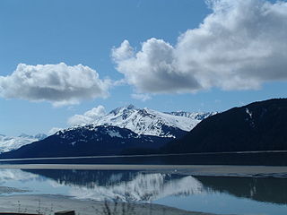
Turnagain Arm is a waterway into the northwestern part of the Gulf of Alaska. It is one of two narrow branches at the north end of Cook Inlet, the other being Knik Arm. Turnagain is subject to climate extremes and large tide ranges.

<span class="mw-page-title-main">Seward Highway</span> State highway in Alaska, United States

The Seward Highway is a highway in the U.S. state of Alaska that extends 125 miles (201 km) from Seward to Anchorage. It was completed in 1951 and runs through the scenic Kenai Peninsula, Chugach National Forest, Turnagain Arm, and Kenai Mountains. The Seward Highway is numbered Alaska Route 9 (AK-9) for the first 37 miles (60 km) from Seward to the Sterling Highway and AK-1 for the remaining distance to Anchorage. At the junction with the Sterling Highway, AK-1 turns west towards Sterling and Homer. About eight miles (13 km) of the Seward Highway leading into Anchorage is built to freeway standards. In Anchorage, the Seward Highway terminates at an intersection with 5th Avenue, which AK-1 is routed to, and which then leads to the Glenn Highway freeway.

<span class="mw-page-title-main">Chugach State Park</span> State park in Alaska, United States

Chugach State Park covers 495,204 acres covering a hilly region immediately east of Anchorage, in south-central Alaska.

<span class="mw-page-title-main">Alyeska Resort</span> United States historic place

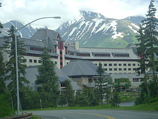
Alyeska Resort is a ski resort in the Girdwood area of Anchorage, Alaska, approximately 30 miles (48 km) from downtown Anchorage. Mount Alyeska is part of the Chugach mountain range and the Alyeska Resort is the largest ski area in the state. It includes the mountaintop Mt. Alyeska Roundhouse, which is listed on the National Register of Historic Places.

<span class="mw-page-title-main">History of Anchorage, Alaska</span>

After congress approved the completion of the Alaska Railroad from Seward to Fairbanks in 1914, it was decided that a new town should be built as a port and rail hub along the route. The decision was made to develop a site near Ship Creek on Cook Inlet. Survey parties visited the area in 1914 and researched possible routes for the rails and options for siting the new town. Anchorage was originally settled as a tent city near the mouth of Ship Creek in 1915, and a planned townsite was platted alongside the bluff to the south. Anchorage was mostly a company town for the Alaska Railroad for its first several decades of existence.

<span class="mw-page-title-main">Anchorage, Alaska</span> Consolidated city-borough in Alaska, United States

The Municipality of Anchorage is the largest city in the U.S. state of Alaska by population. With a population of 291,247 at the 2020 census, it contains nearly 40 percent of the state's population, and has more people than all of Northern Canada and Greenland combined. The Anchorage metropolitan area, which includes Anchorage and the neighboring Matanuska-Susitna Borough, had a population of 398,328 in 2020, accounting for more than half the state's population. At 1,706 sq mi (4,420 km2) of land area, the city is the fourth-largest by area in the United States and larger than the smallest state, Rhode Island, which has 1,212 sq mi (3,140 km2).

Sixmile Creek is a short, approximately 12 miles (19 km) waterway with some of the most exciting whitewater rafting in Alaska. The Six Mile Creek drainage starts as Granite Creek flowing from the top of Turnagain Pass on the Seward Highway, part of the National Scenic Highway Program. Bench Creek and Center Creek join to become East Fork Six Mile Creek and Granite Creek is the largest tributary, contributing most of the water. At the confluence with Canyon Creek, it becomes Six Mile Creek which flows about eight miles to where it empties into Turnagain Arm shortly after flowing past the ghost town of Sunrise along the Hope Highway. There is a scenic outlook just before the Hope Junction with a grand view of the confluence of the creeks and the Canyon Creek Bridge that is pictured on the State of Alaska's website.

<span class="mw-page-title-main">Indian, Anchorage</span> Unincorporated community in the state of Alaska, United States

Indian is a community in the Municipality of Anchorage, Alaska, United States. It lies in a valley in the Chugach Mountains near the middle of the north shore of the Turnagain Arm of Cook Inlet. It is about 24 miles (39 km) southeast of downtown Anchorage and about 3 miles (4.8 km) northwest of Bird, and about 13 miles (21 km) west-northwest of Girdwood.

<span class="mw-page-title-main">Glacier Creek (Turnagain Arm)</span>

Glacier Creek is a 10 miles long stream flowing out of the Chugach Mountains, which enters the Turnagain Arm of Cook Inlet near Girdwood, Alaska.

<span class="mw-page-title-main">Goat Mountain (Alaska)</span> Mountain in Alaska, U.S.

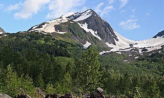
Goat Mountain is a 6,450-foot (1,966 m) mountain summit located in the Chugach Mountains, in Anchorage Municipality in the U.S. state of Alaska. The peak is situated in Chugach National Forest at the head of Glacier Creek Valley, 30 mi (48 km) east-southeast of downtown Anchorage, and 8 mi (13 km) north-northeast of the Alyeska Resort and Girdwood area. The mountain's name was officially adopted in 1932. On August 4, 2019, a small airplane crashed on the mountain claiming all four lives on board.

<span class="mw-page-title-main">Penguin Peak</span> Mountain in Alaska, U.S.

Penguin Peak is a 4,331-foot (1,320 m) mountain summit located in the Chugach Mountains, in Anchorage Municipality in the U.S. state of Alaska. The peak is situated in Chugach State Park, 30 mi (48 km) southeast of downtown Anchorage, and 8 mi (13 km) east of the Alyeska Resort and Girdwood area. The peak is the dominant feature along the north shore of Turnagain Arm when traveling the Seward Highway, and the summit offers a good view of Mount Alpenglow, 6 mi (10 km) directly across Turnagain Arm to the south.

<span class="mw-page-title-main">Mount Alpenglow</span> Mountain in Alaska, U.S.

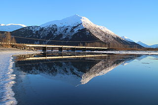
Mount Alpenglow is a 4,816-foot (1,468 m) landmark mountain located in the Kenai Mountains, in the U.S. state of Alaska. The peak is situated in Chugach National Forest, 8 mi (13 km) southwest of Girdwood, Alaska, on the south shore of Turnagain Arm, opposite Bird Point from where it can be prominently seen from the Seward Highway and the Alaska Railroad. Mount Alpenglow is the highest peak alongside Turnagain Arm, and although modest in elevation, relief is significant since the northern aspect of the mountain rises nearly a vertical mile in only one mile from the sea-level shores. The summit of Penguin Peak offers another good view of Alpenglow 6 mi (10 km) directly across the arm.

<span class="mw-page-title-main">Highbush Peak</span> Mountain in Alaska, U.S.

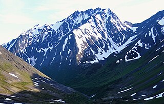
Highbush Peak is a 4,669-foot (1,423 m) elevation mountain summit located in the Chugach Mountains, in Anchorage Municipality in the U.S. state of Alaska. The peak is situated in Chugach National Forest, between the Glacier Creek and Twentymile River valleys, 36 mi (58 km) southeast of downtown Anchorage, and 5 mi (8 km) east of the Alyeska Resort and Girdwood area. Precipitation runoff from the peak drains into Turnagain Arm. This mountain's unofficial name refers to the highbush cranberry. Other berry-theme peaks nearby include Lowbush Peak, Lingon Mountain, Nagoon Mountain, Blueberry Hill, and Bearberry Point.

<span class="mw-page-title-main">Lingon Mountain</span> Mountain in Alaska, U.S.

Lingon Mountain is a 4,098-foot (1,249 m) elevation mountain summit located in the Chugach Mountains, in Anchorage Municipality in the U.S. state of Alaska. The peak is situated in Chugach National Forest, between the Glacier Creek and Twentymile River valleys, 36 mi (58 km) southeast of downtown Anchorage, and 5 mi (8 km) east of the Alyeska Resort and Girdwood areas. Precipitation runoff from the peak drains into Turnagain Arm. This mountain's unofficial name refers to the lingonberry. Other berry-theme peaks nearby include Highbush Peak, Lowbush Peak, Nagoon Mountain, Blueberry Hill, and Bearberry Point.

<span class="mw-page-title-main">Portage Peak</span> Mountain in Alaska, U.S.

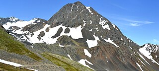
Portage Peak is a 4,347-foot (1,325 m) elevation mountain summit located in the Chugach Mountains, in Anchorage Municipality in the U.S. state of Alaska. The peak is situated in Chugach National Forest, immediately east of Twentymile River valley, and 1.8 mi (3 km) west of Begich Peak. It is set midway between Girdwood and Whittier, with the Portage Glacier Highway and Alaska Railroad traversing the southern base of the mountain. Precipitation runoff from the peak drains into Turnagain Arm via Portage Creek and Twentymile River. This mountain is unofficially named in association with the creek and nearby Portage Lake, Portage Glacier, and Portage ghost town.

<span class="mw-page-title-main">Raggedtop Mountain</span>

Raggedtop Mountain is a 5,215-foot-elevation (1,590-meter) mountain summit in Alaska, United States.

<span class="mw-page-title-main">Jewel Mountain</span>

Jewel Mountain is a 4,885-foot-elevation (1,489-meter) mountain summit in Alaska, United States.

References

  1. "2019 ACS 5-year estimate for Zip Code 99587". US Census Bureau. Retrieved March 30, 2021.
  2. "Recurrent Holocene Paleoseismicity And Associated Land / Sea Level Changes In The Greater Anchorage Area" (PDF). Archived from the original (PDF) on July 29, 2013. Retrieved January 3, 2014.
  3. "Period of Record Climate Summary". Western Regional Climate Center. Retrieved on August 24, 2022
  4. "U.S. Climate Normals Quick Access". National Oceanic and Atmospheric Administration. Retrieved on August 24, 2022
  5. "U.S. Decennial Census". Census.gov. Retrieved June 6, 2013.

60°56′33″N149°09′59″W / 60.94250°N 149.16639°W / 60.94250; -149.16639