Giszowiec

Last updated
Giszowiec
Giszowiec collage.jpg
Katowice-Giszowiec.svg
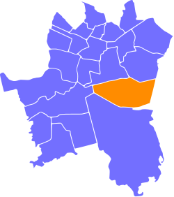
Location of Giszowiec within Katowice
Coordinates: 50°13′25″N19°04′10″E / 50.22361°N 19.06944°E / 50.22361; 19.06944 Coordinates: 50°13′25″N19°04′10″E / 50.22361°N 19.06944°E / 50.22361; 19.06944
CountryFlag of Poland.svg  Poland
Voivodeship Silesian
County/City Katowice
Area
  Total12.03 km2 (4.64 sq mi)
Population
 (2007)
  Total18,475
  Density1,500/km2 (4,000/sq mi)
Time zone UTC+1 (CET)
  Summer (DST) UTC+2 (CEST)
Area code (+48) 032

Giszowiec (German: Gieschewald) is an eastern district of the city of Katowice (Silesian Voivodeship, Poland), created as a coal miners' settlement in 1907. Initially consisting of about 3,300 miners and their families, the district's population have grown over the years to over 18,000. Although Giszowiec's architectural originality suffered major damages in the 1970s and 1980s due to large scale urbanization, its early unique character can be still felt in the surviving miners' housings, the marketplace, numerous individual buildings and structures, as well as the relatively well preserved general design of a "Garden city".

Contents

Location

Giszowiec is located some 7 kilometers southeast from the center of Katowice and its geographical coordinates are 50° 14' N, 19° 04' O coordinates: 50° 14' N, 19° 04' O. Its boundaries are marked in the north by the motorway A4, in the west by the international European route E75, while in the south and in the east, Giszowiec borders the nearby city of Mysłowice. The settlement is somewhat isolated from other Katowice districts and is surrounded by green areas and forests. The neighboring districts are Murcki (3 kilometers to the southwest), as well as Janów and Nikiszowiec in the north.

History

Beginnings

The settlement of Giszowiec does not have a long history. The company "Georg von Giesches Erben", which in late 19th century owned many mines in Upper Silesia, planned its own settlement for workers, and therefore Colonie Gieschewald was founded 1907.

Structure of the colony

The leading director of the settlement was Anton Uthemann, who came up with the basic project. This work was completed by George and Emil Zillmann, architects from Charlottenburg, who designed the settlement inspired by Ebenezer Howard's idea of the "Garden city". In just three years the project was completed: high living standard houses for 600 families were built, with four main streets leading to the central marketplace (today called Plac pod Lipami - Square under the Linden Trees). The settlement had its own institutions, a hotel, department stores, a swimming pool and a water tower. Some dwellings were offered to those miners who lived without family. Most inhabitants worked for the Giesche coal mine (today: Wieczorek coal mine), and the total cost of the colony was estimated at 5 million German Marks. In 1914, a narrow-gauge railway to Janów was opened. Throughout its early history the colony was an independent municipality.

Silesian Uprisings

Inhabitants of the settlement took active part in the Silesian Uprisings, and during the Plebiscite in Upper Silesia, over 70% locals voted for Poland.

Giszowiec in Poland

On 20 June 1922 Gieschewald was renamed Giszowiec and became part of the new Autonomous Silesian Voivodeship and was since then part of the Second Polish Republic. In the subsequent years, numerous Polish associations, among them also a choir were created. Giszowiec lost its independent status in 1924, when it was incorporated into the new municipality of Janów.

German troops occupied the settlement on 4 September 1939. During the occupation, the Nazis tried to destroy everything related to Poland, including a monument of the Silesian Uprising. On 27 January 1945, Red Army captured Giszowiec.

After the Second World War, Giszowiec was merged with Szopienice, but later this decision was voided.

In the course of time the appearance of the colony changed. 1964 were established in the area of the colony after hard coal finds the Staszic Steinkohlebergwerk. In order to take up the inflow of new workers, new populated areas were proven. It was decided that the colony should be torn off and be established in the area a new settlement with zehnstoeckigen blocks of flats. Thus 1969 the Stanisław Staszic housing development was built, which approximated in the next decades ever more near to the old colony. In the western part and East part new disk's buildings replaced the old brick houses, and the colony began to lose their old character of a company-owned housing estate. With the resolutions of the responsible curator of 1978 and 1987 to place the old land development under monument protection the colony could be saved fortunately. In the nineties was begun to maintain and also restore the historical settlement. Nevertheless, only one third of the old land development remained. 1984 were begun with the building of the Barbarapfarrkirche in the Staszic settlement.

Giszowiec is also today still surrounded by forest and is by its relatively large distance to the urban tightness, a popular local recreation place for the inhabitants of the whole city and, since it is the only garden city in Poland, gladly visited and also inhabited. The houses of the colony were transferred 1999 of the city Katowice, since the houses become sold at private people.

Education

In the old colony there is an elementary school number 51(Szkoła Podstawowa nr 51) with approximately 1000 pupils. School building was constructed in 1993 and is the newest in Giszowiec. The two high schools are older. In the seventies the Konopnicka High School (Gimnazjum numer 16 imienia Marii Konopnickiej) was established, the school chronicles go back however until 1908, thus the beginnings of the Gieschewalder school history. Here there are 400 pupils. In addition there exists another high school (Gimnazjum nr 15), with 374 pupils.

Worth seeing

Literature

Related Research Articles

<span class="mw-page-title-main">Silesian Voivodeship</span> Voivodeship of Poland

Silesian Voivodeship, or Silesia Province is a voivodeship, or province, in southern Poland, centered on the historic region known as Upper Silesia, with Katowice serving as its capital.

<span class="mw-page-title-main">Katowice</span> Place in Silesian Voivodeship, Poland

Katowice is the capital city of the Silesian Voivodeship in southern Poland and the central city of the Upper Silesian metropolitan area. It is the 11th most populous city in Poland, while its urban area is the most populous in the country and one of the most populous in the European Union.

<span class="mw-page-title-main">Dąbrowa Górnicza</span> Place in Silesian Voivodeship, Poland

Dąbrowa Górnicza[dɔ̃mˈbrɔva ɡurʲˈɲiʧ̑a] is a city in Zagłębie Dąbrowskie, southern Poland, near Katowice and Sosnowiec. It is located in eastern part of the Silesian Voivodeship, on the Czarna Przemsza and Biała Przemsza rivers.

<span class="mw-page-title-main">Zabrze</span> City in Silesian Voivodeship, Poland

Zabrze is an industrial city in Silesia in southern Poland, near Katowice. The west district of the Silesian Metropolis, a metropolis with a population of around 2 million. It is in the Silesian Highlands, on the Bytomka River, a tributary of the Oder.

<span class="mw-page-title-main">Sosnowiec</span> Place in Silesian Voivodeship, Poland

Sosnowiec is an industrial city county in the Dąbrowa Basin of southern Poland, in the Silesian Voivodeship, which is also part of the Silesian Metropolis municipal association. Located in the eastern part of the Upper Silesian Industrial Region, Sosnowiec is one of the cities of the Katowice urban area, which is a conurbation with the overall population of 2.7 million people; as well as the greater Upper Silesian metropolitan area populated by about 5.3 million people. The population of the city is 194,818 as of December 2021.

<span class="mw-page-title-main">Rybnik</span> Place in Silesian Voivodeship, Poland

Rybnik is a city in southern Poland, in the Silesian Voivodeship, around 38 km (24 mi) southwest of Katowice, the region's capital, and around 19 km from the Czech border. It is one of the major cities of the Upper Silesian metropolitan area with a population of 5.3 million and the main city of the so-called Subregion Zachodni, previously also known as the Rybnik Coal Area. With a population of 135,994 as of January 1, 2022, it is the 25th most-populous city in Poland.

<span class="mw-page-title-main">Chorzów</span> Place in Silesian Voivodeship, Poland

Chorzów is a city in the Silesia region of southern Poland, near Katowice. Chorzów is one of the central cities of the Upper Silesian Metropolitan Union – a metropolis with a population of 2 million. It is located in the Silesian Highlands, on the Rawa River.

<span class="mw-page-title-main">Czerwionka-Leszczyny</span> Place in Silesian Voivodeship, Poland

Czerwionka-Leszczyny is a town in Silesian Voivodeship in southern Poland. It is the only town in Rybnik county and the seat of the larger Czerwionka-Leszczyny municipality which also includes 6 villages. Czerwionka-Leszczyny was created by a merger of two towns and two villages, which to this day maintain their separate identities. As of December 2021, the town has a population of 27,683.

<span class="mw-page-title-main">Wodzisław Śląski</span> Place in Silesian Voivodeship, Poland

Wodzisław Śląski is a city in Silesian Voivodeship, southern Poland with 47,992 inhabitants (2019). It is the seat of Wodzisław County.

<span class="mw-page-title-main">Mysłowice</span> Place in Silesian Voivodeship, Poland

Mysłowice is a city in Silesia in southern Poland, near Katowice. The population of the city as of 2021 is 74,085.

<span class="mw-page-title-main">Tarnowskie Góry</span> Place in Silesian Voivodeship, Poland

Tarnowskie Góry is a town in Silesia, southern Poland, located in the Silesian Highlands near Katowice. On the south it borders the Upper Silesian Metropolitan Union, a megalopolis, the greater Silesian metropolitan area populated by about 5,294,000 people. The population of the town is 61,842 (2021). As of 1999, it is part of Silesian Voivodeship, previously Katowice Voivodeship.

<span class="mw-page-title-main">Horní Suchá</span> Municipality in Moravian-Silesian, Czech Republic

Horní Suchá  is a municipality and village in the Karviná District in the Moravian-Silesian Region of the Czech Republic. It has about 4,400 inhabitants.

Giesche Corp. was, during the interwar period, part of and owned by the German firm of Bergwerksgesellschaft Georg von Giesche's Erben and represented those holdings of Giesche's Erben, that after the implementation of the Treaty of Versailles with re-establishment of the Republic of Poland in 1922, were now in Polish territory; registration at Katowice as a Polish corporation followed with a name that had been registered in Prussia about 1907. The corporation was one of the largest mining concerns operating in Upper Silesia, Poland, during interwar. It had the largest Polish zinc output out of the largest zinc mines in Europe. It was one of the largest bituminous coal producers. It had smelters and rolling mills, factories and agricultural and forests properties. Its largest zinc mine was the White Sharley/Bleischarley Its biggest zinc mills were Giesche and Wilhelmina. The largest coal mines were Giesche and Kleofas. All the former property of Giesche's Erben in Upper Silesia, owned and operated by the Giesche family since 1704. It employed nearly 20,000 workers, for which housing quarters were built, today the monumental district of Katowice.

<span class="mw-page-title-main">Nikiszowiec</span>

Nikiszowiec a part of an administrative district Janów-Nikiszowiec of Katowice city.

East Upper Silesia is the easternmost extremity of Silesia, the eastern part of the Upper Silesian region around the city of Katowice. The term is used primarily to denote those areas that became part of the Second Polish Republic on 20 June 1922, as a consequence of the post-World War I Treaty of Versailles. Prior to World War II, the Second Polish Republic administered the area as Autonomous Silesian Voivodeship. East Upper Silesia was also known as Polish (Upper) Silesia, and the German (Upper) Silesia was known as West Upper Silesia.

<span class="mw-page-title-main">Teofil Ociepka</span> Polish primitivist painter (1891–1978)

Teofil Ociepka was a Polish self-taught primitivist painter, occultist, and theosophist. Along with Nikifor, he was one of the best known Polish primitivists.

<span class="mw-page-title-main">Halemba</span> Ruda Śląska District in Silesian Voivodeship, Poland

Halemba is a district in the south-west of Ruda Śląska, Silesian Voivodeship, southern Poland. It lies on the river Kłodnica, right tritubary of Odra. It has an area of 19.6 km2 and in 2006 it was inhabited by 26,080 people.

The Upper Silesia 1980 strikes were widespread strikes, which took place mostly in the Upper Silesian mining cities Jastrzębie-Zdrój, Wodzisław Śląski and Ruda Śląska and its surroundings, during late August and early September 1980. They forced the Government of People's Republic of Poland to sign the last of three agreements establishing the Solidarity trade union. Earlier, agreements had been signed in Gdańsk and Szczecin. The Jastrzębie Agreement, signed on September 3, 1980, ended Saturday and Sunday work for miners, a concession that Government leaders later said cut deeply into Poland's export earnings.