Related Research Articles

Ørskog is a former municipality in Møre og Romsdal county, Norway. It was part of the Sunnmøre region. The administrative centre was the village of Sjøholt. The other main village was Vaksvika, about 7.5 kilometres (4.7 mi) south of Sjøholt. The European Route E39/E136 highway runs through the municipality, connecting the towns of Ålesund and Molde. Rauma Group is the largest company in Ørskog in terms of turnover.

Vestnes is a municipality in Møre og Romsdal county, Norway. Vestnes is part of the traditional district of Romsdal. The administrative centre of the municipality is the village of Vestnes. Other villages in the municipality include Vikebukt, Vik, Øverås, Fiksdal, Tomrefjord, and Tresfjord.

Nesset is a former municipality in Møre og Romsdal county, Norway on the Romsdal Peninsula. The administrative centre was the village of Eidsvåg. Other population centers included Rausand, Boggestranda, Myklebostad, Eresfjord, and Eikesdalen.

A megatsunami is a very large wave created by a large, sudden displacement of material into a body of water.
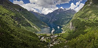
Geiranger is a small tourist village in Sunnmøre region of Møre og Romsdal county in the western part of Norway. It is in the municipality of Stranda at the head of the Geirangerfjorden, which is a branch of the large Storfjorden. The nearest city is Ålesund. Geiranger is home to some of the most spectacular scenery in the world, and has been named the best travel destination in Scandinavia by Lonely Planet. Since 2005, the Geirangerfjord area has been listed as a UNESCO World Heritage Site. The Seven Sisters waterfall is located just west of Geiranger, directly across another waterfall called "The Suitor." Norwegian County Road 63 passes through the village. Geiranger Church is the main church for the village and surrounding area.
Romsdalsfjord or Romsdal Fjord is the ninth-longest fjord in Norway. It is 88 kilometres (55 mi) long and located in the Romsdal district of Møre og Romsdal county. It flows through the municipalities of Molde, Ålesund, Vestnes, and Rauma. The deepest point in the fjord is just southwest of the town of Molde, where it is 550 metres (1,800 ft) deep. Romsdalsfjord is a threshold-fjord, as it is separated from the ocean by a 180-metre (590 ft) deep shallower areas at the mouth. Several islands and skerries also shelter the wide central fjord from the Atlantic.
Tafjord is a village in Fjord Municipality in Møre og Romsdal county, Norway. The village is in a valley located at the end of the Tafjorden, about 12 kilometres (7.5 mi) southeast of the municipal centre of Sylte, and just west of the borders of Reinheimen National Park. In the park, the mountains Tordsnose, Karitinden, and Puttegga all lie about 15 kilometres (9.3 mi) to the southeast of Tafjord in the Tafjordfjella mountain range.
Veøy is a former municipality in Møre og Romsdal county, Norway. The 249-square-kilometre (96 sq mi) municipality existed from 1838 until its dissolution in 1964. It initially consisted of all of the present-day Vestnes Municipality, as well as the southern part of Molde Municipality and the northern part of Rauma Municipality. Vestnes Municipality was only part of Veøy for a few months in 1838 before it was made into a separate municipality. In 1964, the municipality was split between Molde and Rauma municipalities. Veøy Municipality was named after the island of Veøya, the administrative centre, where the main church for the municipality was located.
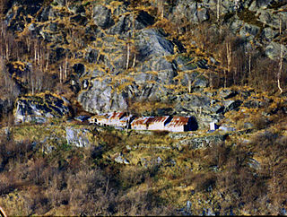
Me-Åkernes or Midtre Åkernes is a deserted fjord farm on the slopes of Åkerneset mountain along the northern shore of the Sunnylvsfjorden in Stranda Municipality in Møre og Romsdal county, Norway. It is located 13 kilometres (8.1 mi) northeast of the village of Hellesylt. The farm is located in the West Norwegian Fjords Norwegian World Heritage Sites and has been preserved both for its unique geologic siting and as a representative of typical Norwegian farm culture in the fjord regions. This geologically unique farm has also been identified as the model for the farm place appearing in Henrik Ibsen’s play Brand based on the similarity in the description and his visit there on 16 July 1862:

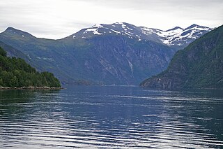
Tafjorden is an inner branch of the Norddalsfjorden/Storfjorden in Fjord Municipality in Møre og Romsdal county, Norway. The fjord is located southeast of the village of Sylte, the municipal center of Norddal Municipality. The small village of Tafjord is located at the end of the 12-kilometre (7.5 mi) long Tafjorden. The only road leading to the rather isolated village of Tafjord goes through the 5,277-metre (3.3 mi) long Heggur Tunnel plus several other smaller tunnels on the northern shore of the fjord.
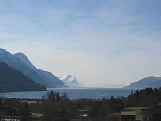
Storfjorden or Storfjord is a 110-kilometre (68 mi) long fjord in the Sunnmøre region of Møre og Romsdal county, Norway. It stretches from the village of Hareid in the west to the villages of Tafjord and Geiranger in the east. The Storfjorden system branches off into several smaller fjords including the famous Geirangerfjord and Tafjorden. At the village of Stranda, the main fjord branches off into the Sunnylvsfjorden-Geirangerfjorden to the west and the Norddalsfjorden-Tafjorden to the east.
Vikebukt is a village in Vestnes Municipality in Møre og Romsdal county, Norway. Along the eastern side of the mouth of the Tresfjorden, it is located just south of where the fjord meets the Romsdalsfjorden. The 0.53-square-kilometre (130-acre) village has a population (2013) of 250, giving the village a population density of 472 inhabitants per square kilometre (1,220/sq mi). Passing through the village is the European route E136 highway.

The Langfjorden is a fjord in Møre og Romsdal county, Norway. The 35-kilometre (22 mi) long fjord is an arm of the large Romsdalsfjord which begins between the most easterly point on the island of Sekken in Molde Municipality and Okseneset in Rauma Municipality. The fjord then continues to the east to the village of Eidsvåg in Molde Municipality.

Eresfjorden is a fjord in Molde Municipality in Møre og Romsdal county, Norway. It is a 10-kilometre (6.2 mi) long branch off of the main Langfjorden, which is itself a branch off the great Romsdal Fjord. The fjord begins at the mouth of the Eira River near the village of Eresfjord, and then it flows north to meet the Langfjorden near the villages of Eidsvåg and Boggestranda.
Stranda is the administrative centre of Stranda Municipality in Møre og Romsdal county, Norway. The village is located on the western shore of the Storfjorden. The 2.4-square-kilometre (590-acre) village has a population (2018) of 2,969 and a population density of 1,237 inhabitants per square kilometre (3,200/sq mi). This is the largest urban area in the municipality.
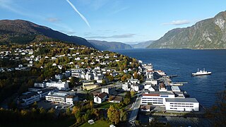
Vestnes is the administrative centre of Vestnes Municipality in Møre og Romsdal county, Norway. The village is located on the western shore of the Tresfjorden, near where the fjord empties into the main Romsdal Fjord. The village lies along the European route E39 highway.

The Tresfjord Bridge is a box girder bridge in Vestnes Municipality in Møre og Romsdal county, Norway.
The Gjermundnes Farm is a Norwegian farm at Gjermundnes in the municipality of Vestnes in Møre og Romsdal county.
The Møre og Romsdal Agricultural Museum is part of the Sunnmøre Museum Foundation. It is located in Gjermundnes in the municipality of Vestnes. The museum was originally a large farm and later on an agricultural school.

The Sunnmøre Museum Foundation is a foundation comprising 12 museums in the Sunnmøre traditional district of the western Norwegian county of Møre og Romsdal.
References
- ↑ "Gjermundnes landbruksskule, Vestnes (Møre og Romsdal)". Yr. Norwegian Meteorological Institute and Norwegian Broadcasting Corporation. Retrieved January 20, 2018.
- ↑ Otterlei, Inger (November 27, 2013). "Nybygg på Gjermundnes". Sunnmørsposten. Retrieved January 20, 2018.
- ↑ Harstad, Lisbet (February 7, 2016). "Jon Georg Dales sjarmøretappe". Nationen. Retrieved January 20, 2018.
- ↑ "Landbruksmuseet for Møre og Romsdal, Gjermundnes" . Retrieved January 19, 2018.
- ↑ "Gjermundnes" (PDF). Møre og Romsdal fylkeskommune. Vestnes kommune. Retrieved January 19, 2018.
- ↑ Hoel, Christer, "The Tjelle Rock Avalanche in 1756," fjords.com Retrieved June 22, 2020