Related Research Articles
The Snowball Earth hypothesis proposes that, during one or more of Earth's icehouse climates, the planet's surface became entirely or nearly entirely frozen. It is believed that this occurred sometime before 650 M.Y.A. during the Cryogenian period. Proponents of the hypothesis argue that it best explains sedimentary deposits that are generally believed to be of glacial origin at tropical palaeolatitudes and other enigmatic features in the geological record. Opponents of the hypothesis contest the implications of the geological evidence for global glaciation and the geophysical feasibility of an ice- or slush-covered ocean, and they emphasize the difficulty of escaping an all-frozen condition. A number of unanswered questions remain, including whether Earth was a full snowball or a "slushball" with a thin equatorial band of open water.
Paleoclimatology is the study of climates for which direct measurements were not taken. As instrumental records only span a tiny part of Earth's history, the reconstruction of ancient climate is important to understand natural variation and the evolution of the current climate.
Sequence stratigraphy is a branch of geology that attempts to subdivide and link sedimentary deposits into unconformity bound units on a variety of scales and explain these stratigraphic units in terms of variations in sediment supply and variations in the rate of change in accommodation space. The essence of the method is mapping of strata based on identification of surfaces which are assumed to represent time lines, and therefore placing stratigraphy in chronostratigraphic framework. Sequence stratigraphy is a useful alternative to a lithostratigraphic approach, which emphasizes similarity of the lithology of rock units rather than time significance.

The Quaternary glaciation, also known as the Pleistocene glaciation, is an alternating series of glacial and interglacial periods during the Quaternary period that began 2.58 Ma and is ongoing. Although geologists describe the entire time period up to the present as an "ice age", in popular culture the term "ice age" is usually associated with just the most recent glacial period during the Pleistocene or the Pleistocene epoch in general. Since planet Earth still has ice sheets, geologists consider the Quaternary glaciation to be ongoing, with the Earth now experiencing an interglacial period.
The geology of the Netherlands describes the geological sequence of the Netherlands. Large parts of the Netherlands today are below sea level and have in the past been covered by the sea or flooded at regular intervals. The modern Netherlands formed as a result of the interplay of the four main rivers and the influence of the North Sea and glaciers during ice-ages. The Netherlands is mostly composed of deltaic, coastal and eolian derived sediments during the Pleistocene glacial and interglacial periods.

The late Paleozoic icehouse, also known as the late Paleozoic ice age and formerly known as the Karoo ice age, occurred from 360 to 260 million years ago (Mya), and large land-based ice-sheets were then present on Earth's surface. It was the second major glacial period of the Phanerozoic. It is named after the tillite found in the Karoo Basin of South Africa, where evidence for the ice age was first clearly identified in the 19th century.

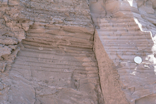
A tunnel valley is a U-shaped valley originally cut under the glacial ice near the margin of continental ice sheets such as that now covering Antarctica and formerly covering portions of all continents during past glacial ages. They can be as long as 100 km (62 mi), 4 km (2.5 mi) wide, and 400 m (1,300 ft) deep.

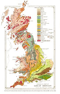
The geology of England is mainly sedimentary. The youngest rocks are in the south east around London, progressing in age in a north westerly direction. The Tees-Exe line marks the division between younger, softer and low-lying rocks in the south east and the generally older and harder rocks of the north and west which give rise to higher relief in those regions. The geology of England is recognisable in the landscape of its counties, the building materials of its towns and its regional extractive industries.
The geology of Wales is complex and varied; its study has been of considerable historical significance in the development of geology as a science. All geological periods from the Cryogenian to the Jurassic are represented at outcrop, whilst younger sedimentary rocks occur beneath the seas immediately off the Welsh coast. The effects of two mountain-building episodes have left their mark in the faulting and folding of much of the Palaeozoic rock sequence. Superficial deposits and landforms created during the present Quaternary period by water and ice are also plentiful and contribute to a remarkably diverse landscape of mountains, hills and coastal plains.
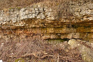
A rhythmite consists of layers of sediment or sedimentary rock which are laid down with an obvious periodicity and regularity. They may be created by annual processes such as seasonally varying deposits reflecting variations in the runoff cycle, by shorter term processes such as tides, or by longer term processes such as periodic floods.
The geology of the North Sea describes the geological features such as channels, trenches, and ridges today and the geological history, plate tectonics, and geological events that created them.

The Dwyka Group is one of four geological groups that compose the Karoo Supergroup. It is the lowermost geological group and heralds the commencement of sedimentation of the Karoo Supergroup. Based on stratigraphic position, lithostratigraphic correlation and palynological analyses, these lowermost Karoo strata range between the Late Carboniferous (Pennsylvanian) to Early Permian in age.
The Late Ordovician glaciation, also known as the Hirnantian glaciation or end-Ordovician glaciation, is the first part of the Andean-Saharan glaciation. It was centered on the Sahara region in late Ordovician, about 440–460 Ma. The major glaciation during this period is widely considered to be the leading cause of the Ordovician-Silurian extinction event. Evidence of this glaciation can be seen in places such as Morocco, South Africa, Libya, and Wyoming. More evidence derived from isotopic data is that during the Late Ordovician, tropical ocean temperatures were about 5 °C cooler than present day; this would have been a major factor that aided in the glaciation process.
The Corossol structure, which is also known as the Corossol crater, is a circular, 4.3-by-3.9-kilometre in diameter, underwater bedrock feature that is exposed on the gulf floor of the northwestern Gulf of Saint Lawrence 20-kilometre (12 mi) offshore of the city of Sept-Îles, Quebec in eastern Canada. It is hypothesized to be a possible pre-Pleistocene, extraterrestrial impact structure. It lies underwater at a depth of 40–208-metre (131–682 ft). This underwater feature was found during the study of high-resolution bathymetric and sub-bottom profiler data collected south of the city of Sept-Iles in the northwestern Gulf of Saint Lawrence.
The geology of the Baltic Sea is characterized by having areas located both at the Baltic Shield of the East European Craton and in the Danish-North German-Polish Caledonides. Historical geologists make a distinction between the current Baltic Sea depression, formed in the Cenozoic era, and the much older sedimentary basins whose sediments are preserved in the zone. Although glacial erosion has contributed to shape the present depression, the Baltic trough is largely a depression of tectonic origin that existed long before the Quaternary glaciation.

The geology of England's Lake District is dominated by sedimentary and volcanic rocks of mainly Ordovician age underpinned by large granitic intrusions. Younger sedimentary sequences outcrop on the edges of the Lake District area, with Silurian to the south, Carboniferous to the north, east and west and Permo-Triassic to the west and east. The entire area was covered by a Mesozoic sequence that was eroded off during Paleogene uplift related to the opening of the North Atlantic. During the Quaternary the area was affected by repeated glaciations, which sculpted the current mountainous landscape.

The geology of Rhode Island is based on nearly one billion year old igneous crystalline basement rocks formed as part of the microcontinent Avalonia that collided with the supercontinent Gondwana. The region experienced substantial folding associated with its landlocked position during the Alleghanian orogeny mountain building event. The region accumulated sedimentary rocks, including small deposits of coal. The region was covered with thick Atlantic Coastal Plain sediments, with the erosion of the Appalachians and the creation of the Atlantic Ocean throughout the past 200 million years. These surficial sediments and soils were substantially reworked by the Pleistocene glaciations. The state's geology is part of the broader geology of New England.

The geology of Slovakia is structurally complex, with a highly varied array of mountain ranges and belts largely formed during the Paleozoic, Mesozoic and Cenozoic eras.
Geology of Latvia includes an ancient Archean and Proterozoic crystalline basement overlain with Neoproterozoic volcanic rocks and numerous sedimentary rock sequences from the Paleozoic, some from the Mesozoic and many from the recent Quaternary past. Latvia is a country in the Baltic region of Northern Europe.
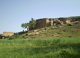
The Enticho Sandstone is a geological formation in north Ethiopia. It forms the lowermost sedimentary rock formation in the region and lies directly on the basement rocks. Enticho Sandstone consists of arenite that is rich in quartz. The formation has a maximum thickness of 200 metres. Locally, its upper part is coeval with the Edaga Arbi Glacials. The Enticho Sandstone has been deposited during the Ordovician, as evidenced by impressions of organisms.
References
- ↑ Siegert, M.J., Le Brocq, A. And Payne A. Hydrological connections between Antarctic subglacial lakes and the flow of water beneath the East Antarctic Ice Sheet. In, Glacial Sedimentary Processes and Products (Hambrey, M.J., Christoffersen, P., Glasser, N.F. and Hubbard, B.P). Special Publication #39, International Association of Sedimentologists, 3-10. (2007).
- ↑ M. Huuse, and H. Lykke-Andersen (2000).Overdeepened Quaternary valleys in the eastern Danish North Sea: morphology and origin. Quaternary Science Reviews 19. p. 1233-1253
- ↑ Daniel Praeg (2003). Seismic imaging of mid-Pleistocene tunnel-valleys in the North Sea Basin—high resolution from low frequencies. Journal of Applied Geophysics 53. 273– 298
- ↑ Ghienne, J.F., & Deynoux, M. 1998. Large-scale channel fill structures in Late Ordovician glacial deposits in Mauritania, western Sahara. Sedimentary Geology 119. p.141-159
- ↑ J. N. J. Visser (1988). A Permo-Carboniferous tunnel valley system east of Barkly West, northern Cape Province. South African Journal of Geology; September 1988; v. 91; no. 3. p. 350-357.