Gladstone, New Zealand

Last updated

Gladstone
Locality
Gladstone Pub (23192519723).jpg
Gladstone Inn
Gladstone, New Zealand
Coordinates: 41°05′S175°39′E / 41.083°S 175.650°E / -41.083; 175.650 Coordinates: 41°05′S175°39′E / 41.083°S 175.650°E / -41.083; 175.650
Country New Zealand
Region Wellington Region
Territorial authority Carterton District
Area
[1]
  Total621.33 km2 (239.90 sq mi)
Population
 (June 2020) [2]
  Total900
  Density1.4/km2 (3.8/sq mi)
Gladstone Church, rebuilt in 1955 Gladstone Church side.jpg
Gladstone Church, rebuilt in 1955

Gladstone is a lightly populated locality [3] in the Carterton District of New Zealand's North Island, located on the Mangahuia Stream near where the Tauweru River joins the Ruamahanga River. The nearest town is Carterton 15 kilometres to the northwest, and nearby settlements include Ponatahi to the west and Longbush to the south. It was named after British prime minister William Ewart Gladstone. [4]

Contents

Several other localities in the country are also called Gladstone - an Invercargill suburb, a coastal sawmill village south of Greymouth, a hamlet beside Lake Hāwea and an area near Levin. [5]

History and culture

Thirty-four deceased soldiers from Gladstone and its surrounds are commemorated by a small roadside war memorial, and part of the main road between Masterton and Gladstone is lined with 36 memorial oaks. Why there are thirty-six rather than thirty-four oaks is unknown. [6]

Marae

The local Hurunui o Rangi Marae is affiliated with the Ngāti Kahungunu hapū of Ngāi Tahu, Ngāi Taneroroa, Ngāti Hinewaka, Ngāti Kaparuparu, Ngāti Moe, Ngāti Parera, Ngāti Rangitataia, Ngāti Rangitehewa, Ngāti Tatuki and Ngāti Te Tomo o Kahungunu, and the Rangitāne hapū of Ngāi Tahu. [7] [8]

In October 2020, the New Zealand Government committed $2,179,654 from the Provincial Growth Fund to upgrade Ngāi Tumapuhia a Rangi ki Okautete, Motuwairaka, Pāpāwai, Kohunui, Hurunui o Rangi and Te Oreore marae. The projects were expected to create 19.8 full time jobs. [9]

Demographics

Gladstone statistical area covers 621.33 km2 (239.90 sq mi). [1] It had an estimated population of 900 as of June 2020, [2] with a population density of 1.4 people per km2.

Historical population
YearPop.±% p.a.
2006711    
2013816+1.99%
2018870+1.29%
Source: [10]

Gladstone had a population of 870 at the 2018 New Zealand census, an increase of 54 people (6.6%) since the 2013 census, and an increase of 159 people (22.4%) since the 2006 census. There were 333 households. There were 450 males and 417 females, giving a sex ratio of 1.08 males per female. The median age was 42.6 years (compared with 37.4 years nationally), with 198 people (22.8%) aged under 15 years, 111 (12.8%) aged 15 to 29, 441 (50.7%) aged 30 to 64, and 120 (13.8%) aged 65 or older.

Ethnicities were 93.4% European/Pākehā, 13.4% Māori, 1.0% Pacific peoples, 0.7% Asian, and 2.1% other ethnicities (totals add to more than 100% since people could identify with multiple ethnicities).

The proportion of people born overseas was 12.4%, compared with 27.1% nationally.

Although some people objected to giving their religion, 55.5% had no religion, 34.8% were Christian, 0.3% were Hindu and 2.1% had other religions.

Of those at least 15 years old, 174 (25.9%) people had a bachelor or higher degree, and 78 (11.6%) people had no formal qualifications. The median income was $41,000, compared with $31,800 nationally. The employment status of those at least 15 was that 390 (58.0%) people were employed full-time, 126 (18.8%) were part-time, and 9 (1.3%) were unemployed. [10]

Economy

Looking north-west from Gladstone, Spring 2014 Pasture against snow (15346066851) (cropped).jpg
Looking north-west from Gladstone, Spring 2014

Gladstone is primarily a farming community and some viticulture occurs in the area. Viticultural activity is increasing as winemakers realise the potential of soil and climate that produce low yielding rich concentrated grapes. Gladstone also has a number of small businesses and industries, including cafes, homestays, and a wheelwright shop. [4] The Summit Lodge is Gladstone's five star rated guest lodge which has been hosting guests since it was built in 2009. [11]

The Gladstone Inn, known to locals as "The Gladdy", is Gladstone's local pub. [12] It was voted the best country hotel in New Zealand in 2006 survey by the New Zealand Hospitality Association. [13]

Gladstone also has a sports complex, built in 1979 [14] - which is owned and run by the local community. Admiral Rd is often used by international cycling competitions [15] and it was first "Everested" in 2017 [16]

Education

Gladstone School is the local primary school accommodating approximately 100 children. [17] This has been the main school for the area since the closure of schools in Longbush, Maungaraki, and Te Whiti in 1968. [18]

During the 2010s, the school gained popularity, taking children from Carterton, Martinborough, and Masterton. [17]

Sport

A sports complex is located in Gladstone near the pub. It is the home of Gladstone's rugby union, hockey and netball clubs.

The Wairarapa Pistol and Shooting Sports Club (formerly the Wairarapa Pistol Club) has a shooting range in the area.

Related Research Articles

Ngāi Tahu Māori iwi (tribe) of the South Island, New Zealand

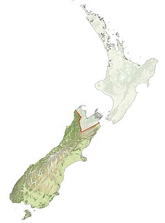
Ngāi Tahu, or Kāi Tahu, is the principal Māori iwi (tribe) of the South Island. Its takiwā is the largest in New Zealand, and extends from the White Bluffs / Te Parinui o Whiti, Mount Mahanga and Kahurangi Point in the north to Stewart Island / Rakiura in the south. The takiwā comprises 18 rūnanga corresponding to traditional settlements.

Masterton Town in the North Island of New Zealand

Masterton, a large town in the Greater Wellington Region of New Zealand, operates as the seat of the Masterton District. It is the largest town in the Wairarapa, a region separated from Wellington by the Rimutaka ranges. It stands on the Waipoua stream between the Ruamahunga and Waingawa Rivers - 100 kilometres north-east of Wellington and 39.4 kilometres south of Eketahuna.

Ngāti Porou Māori iwi (tribe) in Aotearoa New Zealand

Ngāti Porou is a Māori iwi traditionally located in the East Cape and Gisborne regions of the North Island of New Zealand. Ngāti Porou is affiliated with the 28th Maori Battalion and has the second-largest affiliation of any iwi in New Zealand, with 71,910 registered members in 2006. The traditional rohe or tribal area of Ngāti Porou extends from Pōtikirua and Lottin Point in the north to Te Toka-a-Taiau in the south.

Ngāti Kahungunu Māori iwi (tribe) in Aotearoa New Zealand

Ngāti Kahungunu is a Māori iwi (tribe) located along the eastern coast of the North Island of New Zealand. The iwi is traditionally centred in the Hawke's Bay and Wairārapa regions.

Martinborough Town in the North Island of New Zealand

Martinborough is a town in the South Wairarapa District, in the Wellington region of New Zealand. It is 65 kilometres east of Wellington and 35 kilometres south-west of Masterton. The town has a resident population of 1,930.

Tikokino is a town in the Central Hawke's Bay District on the east coast of the North Island of New Zealand. It is located 20 kilometres (12 mi) northwest of Waipawa and 55 kilometres (34 mi) southwest of Hastings. The township is located on State Highway 50.

Greytown, New Zealand Town in the North Island of New Zealand

Greytown, population 2,202, is a rural town in the centre of the Wairarapa region of New Zealand, in the lower North Island. It is 80 km north-east of Wellington and 25 kilometres southwest of Masterton, on State Highway 2. It was awarded the title of New Zealand's Most Beautiful Small Town 2017.

Māhia Peninsula Peninsula in Hawkes Bay, New Zealand

Māhia Peninsula is located on the east coast of New Zealand's North Island, in the Hawke's Bay region, between the towns of Wairoa and Gisborne.

Ngāi Te Rangi Māori iwi (tribe) in Aotearoa New Zealand

Ngāi Te Rangi or Ngāiterangi is a Māori iwi, based in Tauranga, New Zealand. Its rohe extends to Mayor Island / Tuhua and Bowentown in the north, to the Kaimai Range in the west, south of Te Puke and to Maketu in the east.

Longbush, Wellington Place in Wellington, New Zealand

Longbush is a rural community in the Carterton District, Wairarapa of New Zealand's North Island. It is located in a valley southeast of the town of Carterton, and nearby settlements include Gladstone and Ponatahi to the north.

Te Whiti, formerly Te Whiti o Tu in the nineteenth century, is a rural community in the Wairarapa region of New Zealand's North Island. Its status has been under dispute and threatened in the twentieth century, and Land Information New Zealand acknowledges Te Whiti solely as a homestead. Its full former name means "the place of crossing" in the Māori language, reflecting its location near a natural crossing of the Ruamahanga River where it is met by the Waingawa River. The Ruamahunga River runs north and west of the locality and is also met by the Tauweru River that flows across the south of Te Whiti. In relation to major Wairarapa centres, Te Whiti is south of Masterton and east of Carterton, while nearby communities include Te Whanga to the east and Gladstone and Longbush to the south. The Maungaraki Range is also nearby.

Raupunga is a small settlement in the northern Hawke's Bay Region of New Zealand's eastern North Island. It is located close to the country's highest railway bridge, the Mohaka Viaduct, which crosses the Mohaka River. The predominantly Māori village is expected to have a population of 266 people by 2033.

Nūhaka Place in New Zealand

Nūhaka is a small settlement in the northern Hawke's Bay Region of New Zealand's eastern North Island, lying on State Highway 2 between Wairoa and Gisborne.

Frasertown Place in Hawkes Bay, New Zealand

Frasertown is a small settlement in the northern Hawke's Bay Region of New Zealand's eastern North Island.

Ngāi Tāmanuhiri Māori iwi (tribe) in Aotearoa New Zealand

Ngāi Tāmanuhiri is a Māori iwi of New Zealand and were formerly known by the name of Ngai Tahu, and Ngai Tahu-po respectively. They are descendants of Tahu-nui who is also the eponymous ancestor of the Kai Tahu iwi of Te Waipounamu.

Whareama is a rural area in the Wellington Region of New Zealand's North Island. The Whareama River flows through the area.

Ngāti Rakaipaaka is a Māori hapu (subtribe), from the Nuhaka area of northern Hawke's Bay on New Zealand's North Island. It is a subtribe of Ngāti Kahungunu.

Moawhango Rural community in Manawatū-Whanganui, New Zealand

Moawhango is a rural community in the northern part of Rangitikei District of the Manawatū-Whanganui region of New Zealand's North Island. It is situated 19 km north of Taihape and 91 km northeast of Marton. Nearby Moawhango are located Moawhango River and Lake Moawhango.

Maungaharuru Tangitū is a collective of Māori hapū (subtribes) of the Ngāti Kahungunu iwi in Hawke's Bay, New Zealand, who joined forces for Treaty of Waitangi settlement negotiations. The several hapū are Marangatūhetaua, Ngāi Tauira, Ngāi Te Ruruku ki Tangoio, Ngāi Tahu, Ngāti Kurumōkihi and Ngāti Whakaari. The group's rohe ranges from Bay View in the south to the Waitaha Stream in the north, and from the Maungaharuru Range in the west to the sea in Hawke Bay, that part of the sea being known as Tangitū.

Pirinoa Place in Wellington, New Zealand

Pirinoa is a rural community east of Lake Wairarapa, in the South Wairarapa District and Wellington Region of New Zealand's North Island. It includes the rural settlement of Pirinoa, and the coastal settlement of Whāngaimoana.

References

Commons-logo.svg Media related to Gladstone, New Zealand at Wikimedia Commons

  1. 1 2 "ArcGIS Web Application". statsnz.maps.arcgis.com. Retrieved 9 July 2021.
  2. 1 2 "Population estimate tables - NZ.Stat". Statistics New Zealand . Retrieved 22 October 2019.
  3. "Place name detail: Gladstone". New Zealand Gazetteer. New Zealand Geographic Board . Retrieved 17 March 2018.
  4. 1 2 Te Ara: The Encyclopedia of New Zealand, "Carterton", accessed 31 May 2007.
  5. "New Zealand Topographic Map". NZ Topo Map. Retrieved 23 December 2018.
  6. Gareth Winter, "Maungaraki War Memorial, Gladstone", accessed 31 May 2007.
  7. "Te Kāhui Māngai directory". tkm.govt.nz. Te Puni Kōkiri.
  8. "Māori Maps". maorimaps.com. Te Potiki National Trust.
  9. "Marae Announcements" (Excel). growregions.govt.nz. Provincial Growth Fund. 9 October 2020.
  10. 1 2 "Statistical area 1 dataset for 2018 Census". Statistics New Zealand. March 2020. Gladstone (Carterton District) (257200). 2018 Census place summary: Gladstone (Carterton District)
  11. http://www.summitlodge.co.nz
  12. "Iconic pub inches from glory". The New Zealand Herald . 8 September 2006. Retrieved 1 October 2011.
  13. Hospitality Association of New Zealand, "Top Award for Local Country Pub", HANZ Media Release (28 September 2006), accessed 10 November 2007.
  14. http://www.gladstonesportscomplex.co.nz/Home/
  15. https://www.stuff.co.nz/sport/other-sports/100565580/race-to-the-top-the-very-top-of-admiral-hill-likely-to-decide-this-years-nz-cycle-classic
  16. https://www.stuff.co.nz/sport/90876217/everesting-admiral-hill-took-cyclist-to-dark-places-in-the-mind
  17. 1 2 Education Review Office, Education Review Report: Gladstone School [ permanent dead link ], February 2005, accessed 31 May 2007.
  18. Hugh Barlow, "Te Whiti and Proud of It" Archived 2008-10-14 at the Wayback Machine , Wairarapa Times-Age, 2 September 2000.

[1]

  1. The Gladstone Project community website