
East Dunbartonshire is one of the 32 council areas of Scotland. It borders the north-west of Glasgow and contains many of the affluent areas to the north of the city, including Bearsden, Milngavie, Balmore and Torrance, as well as many of the city's commuter towns and villages. East Dunbartonshire also shares borders with North Lanarkshire, Stirling and West Dunbartonshire. The council area covers parts of the historic counties of Dunbartonshire, Lanarkshire and Stirlingshire.

Lanarkshire, also called the County of Lanark, is an historic county, lieutenancy area and registration county in the central Lowlands of Scotland.
Strathkelvin is the strath of the River Kelvin in west central Scotland, close to the city of Glasgow. The name Strathkelvin was formerly (1975–96) used for one of nineteen local government districts in the Strathclyde region of Scotland.

The Campsie Fells are a range of hills in central Scotland, stretching east to west from Denny Muir to Dumgoyne in Stirlingshire and overlooking Strathkelvin to the south. The southern extent of the range falls within East Dunbartonshire. The range overlooks the villages of Strathblane, Blanefield, Milton Of Campsie, Lennoxtown and Torrance to the south; Killearn to the west, and Fintry and Strathendrick to the north. The Fintry Hills lie further to the north; Kilpatrick Hills lie to the west and the Kilsyth Hills to the east.

Cumbernauld, Kilsyth and Kirkintilloch East is a constituency of the House of Commons of the Parliament of the United Kingdom. It was created for the 2005 general election, replacing Cumbernauld and Kilsyth and part of Strathkelvin and Bearsden.

The Lennox is a region of Scotland centred on The Vale of Leven, including its great loch: Loch Lomond.

The River Kelvin is a tributary of the River Clyde in northern and northeastern Glasgow, Scotland. It rises on the moor south east of the village of Banton, east of Kilsyth. At almost 22 miles (35 km) long, it initially flows south to Dullatur Bog where it falls into a man made trench and takes a ninety degree turn flowing west through Strathkelvin and along the northern boundary of the bog parallel with the Forth and Clyde Canal.

The River Leven is a stretch of water in West Dunbartonshire, Scotland, flowing from Loch Lomond in the North to the River Clyde in the South. The river is about 6 miles long. It is very popular with salmon and sea trout anglers, trying to catch one of these migratory fish going up to Loch Lomond.

Baldernock meaning 'settlement of St Earnaig' is a small parish in East Dunbartonshire, Scotland, ten miles (16 km) to the north of Glasgow's city centre.

Torrance is a relatively affluent village in East Dunbartonshire, formerly Stirlingshire, Scotland, located 8 miles (13 km) north of Glasgow city centre. Torrance used to mainly consist of farmland. The village was once famous as a resting place for workers on their way to the Campsie Fells 4 miles (6.4 km) north. The Forth and Clyde Canal has a wharf nearby at Hungryside, and the A807 runs along its southern edge. The village has an active community charity whose aims are to improve the village facilities.
Campsie is a civil parish in East Dunbartonshire, Scotland. The parish was formerly part of Stirlingshire.
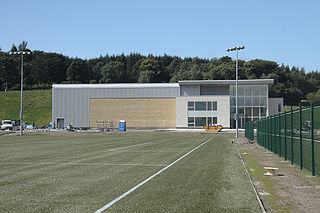
Lennoxtown Training Centre is Celtic F.C.'s training centre, located at Lennoxtown, East Dunbartonshire in Scotland. The complex houses the club's training and educational facilities.

The Kilpatrick Hills are a range of hills in central Scotland, stretching from Dumbarton in the west to Strathblane in the east. Strathblane divides the Kilpatricks from the Campsie Fells to the east, while to the north is part of the Loch Lomond and the Trossachs National Park. To west and south the hills are fringed by the settlements of Balloch, Dumbarton, Milton, Bowling, Old Kilpatrick, Clydebank, Bearsden and Milngavie. The majority of the range is within West Dunbartonshire, although it extends into the East Dunbartonshire and Stirling areas.
Clachan of Campsie or Campsie Glen is a settlement in the East Dunbartonshire area of Scotland. It was formerly part of the county of Stirlingshire. It is situated to the south of the Campsie Fells at the foot of Campsie Glen where the Finglen and Aldessan Burns meet, forming the Glazert Water which then flows south-east until it joins the River Kelvin near Kirkintilloch.

The Allander Water is a river in East Dunbartonshire and Stirling, Scotland, and one of the three main tributaries of the River Kelvin, the others being the Glazert Water and the Luggie Water. It flows through Milngavie.

Ballikinrain is an independent residential school in Stirling, central Scotland. It is run by CrossReach, a social care outreach arm of the Church of Scotland. The school is housed in the 19th-century Ballikinrain Castle, situated in the Parish of Killearn, 2 kilometres (1.2 mi) south-east of Balfron and 5 kilometres (3.1 mi) west of Fintry.

The Luggie Water is one of two streams which flow out of Cumbernauld. The Scottish New Town’s name derives from the Gaelic for "the meeting of the waters", which possibly refers to the Luggie Water and the Red Burn, both of which run through Cumbernauld but which never meet.

Vale of Leven Academy is a non-denominational secondary school in West Dunbartonshire, Scotland. The school serves the surrounding towns of Alexandria, Balloch, Bonhill, Jamestown, and Renton. The current school building, opened in June 2009, has a capacity for approximately 1,100 pupils.
Located in East Dunbartonshire, the Aldessan Burn is formed as headwaters which descend from the Campsie Fells. The Burn flows through Campsie Glen to Clachan of Campsie and upon merging with the Finglen Burn a half-mile (1 km) to the southeast, forms the Glazert Water.

Torrance railway station was opened in 1879 on the Kelvin Valley Railway and served the area of the village of Torrance in East Dunbartonshire until 1951 for passengers and 1959 for freight.
