Glen Allyn

Last updated

Glen Allyn
Queensland
Nerada Tea Plantation at Glen Allyn on the Atherton Tableland, 1986.jpg
Nerada Tea Plantation at Glen Allyn on the Atherton Tableland, 1986
Australia Queensland location map.svg
Red pog.svg
Glen Allyn
Coordinates 17°22′42″S145°39′39″E / 17.3783°S 145.6608°E / -17.3783; 145.6608 (Glen Allyn (centre of locality))
Population109 (2021 census) [1]
 • Density2.698/km2 (6.99/sq mi)
Postcode(s) 4885
Area40.4 km2 (15.6 sq mi)
Time zone AEST (UTC+10:00)
LGA(s) Tablelands Region
State electorate(s) Hill
Federal division(s) Kennedy
Suburbs around Glen Allyn:
Malanda North Johnstone North Johnstone
Jaggan Glen Allyn Butchers Creek
Tarzali Topaz Topaz

Glen Allyn is a rural locality in the Tablelands Region, Queensland, Australia. [2] In the 2021 census, Glen Allyn had a population of 109 people. [1]

Contents

Geography

Lamins Hill is a mountain near the eastern edge of the locality ( 17°22′47″S145°42′18″E / 17.3796°S 145.7049°E / -17.3796; 145.7049 (Lamins Hill) ) 876 metres (2,874 ft) above sea level. [3] [4]

History

Glen Allyn State School opened on 1 September 1920 and closed on 1965. [5]

Demographics

In the 2016 census Glen Allyn had a population of 157 people. [6]

In the 2021 census, Glen Allyn had a population of 109 people. [1]

Attractions

The Nerada Tea plantation and factory are at 933 Glen Allyn Road ( 17°23′01″S145°40′02″E / 17.3835°S 145.6672°E / -17.3835; 145.6672 (Nerada Tea) ). [7] The company is Australian's largest tea producer. [8]

Lamins Hill Lookout is on the Old Cairns Track off Topaz Road ( 17°22′37″S145°42′18″E / 17.3770°S 145.7051°E / -17.3770; 145.7051 (Lamins Hill Lookout) ). [9]

Related Research Articles

<span class="mw-page-title-main">Tinaroo, Queensland</span> Suburb of Tablelands Region, Queensland, Australia

Tinaroo is a rural locality in the Tablelands Region, Queensland, Australia. In the 2021 census, Tinaroo had a population of 293 people.

<span class="mw-page-title-main">Millaa Millaa, Queensland</span> Town in Queensland, Australia

Millaa Millaa is a rural town and locality in the Tablelands Region, Queensland, Australia. In the 2016 census, the locality of Millaa Millaa had a population of 514 people.

<span class="mw-page-title-main">Mutchilba, Queensland</span> Town in Queensland, Australia

Mutchilba is a rural town and locality in the Shire of Mareeba, in Far North Queensland, Australia. It is known for its production of mangoes.

<span class="mw-page-title-main">Lake Eacham, Queensland</span> Suburb of Tablelands Region, Queensland, Australia

Lake Eacham is a rural locality in the Tablelands Region, Queensland, Australia. In the 2021 census, Lake Eacham had a population of 459 people.

<span class="mw-page-title-main">Brinsmead, Queensland</span> Suburb of Cairns, Queensland, Australia

Brinsmead is a suburb of Cairns in the Cairns Region, Far North Queensland, Australia. In the 2021 census, Brinsmead had a population of 5,537 people.

<span class="mw-page-title-main">Arriga, Queensland</span> Suburb of Shire of Mareeba, Queensland, Australia

Arriga is a rural locality in the Shire of Mareeba, Queensland, Australia. It has Queensland's largest wind farm. In the 2021 census, Arriga had a population of 1,323 people.

Lake Tinaroo is a rural locality in the Tablelands Region of Queensland, Australia. In the 2021 census, Lake Tinaroo had a population of 3 people.

Barmaryee is a rural locality in the Livingstone Shire, Queensland, Australia. In the 2021 census, Barmaryee had a population of 925 people.

<span class="mw-page-title-main">Lake Barrine, Queensland</span> Suburb of Tablelands Region, Queensland, Australia

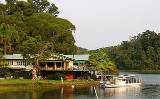
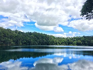
Lake Barrine is a rural locality in the Tablelands Region, Queensland, Australia. In the 2021 census, Lake Barrine had a population of 170 people.

Minbun is a rural locality in the Tablelands Region, Queensland, Australia. In the 2016 census Minbun had a population of 75 people.

<span class="mw-page-title-main">Peeramon</span> Town in Queensland, Australia

Peeramon is a rural town and locality in the Tablelands Region, Queensland, Australia. In the 2016 census, the locality of Peeramon had a population of 628 people.

<span class="mw-page-title-main">Upper Barron</span> Suburb of Tablelands Region, Queensland, Australia

Upper Barron is a rural locality in the Tablelands Region, Queensland, Australia. In the 2021 census, Upper Barron had a population of 503 people.

Moomin is a rural locality in the Tablelands Region, Queensland, Australia. In the 2016 census Moomin had a population of 133 people.

<span class="mw-page-title-main">Wooroonooran, Queensland</span> Suburb of Cairns Region, Queensland, Australia

Wooroonooran is an undeveloped locality split among the Cairns Region, the Cassowary Coast Region and the Tablelands Region in Queensland, Australia. In the 2021 census, Wooroonooran had a population of 4 people.

<span class="mw-page-title-main">Macalister Range, Queensland</span> Suburb of Cairns Region, Queensland, Australia

Macalister Range is a coastal locality in the Cairns Region, Queensland, Australia. In the 2021 census, Macalister Range had a population of 0 people.

<span class="mw-page-title-main">Danbulla, Queensland</span> Suburb of Tablelands Region, Queensland, Australia

Danbulla is a locality in the Tablelands Region, Queensland, Australia. In the 2021 census, Danbulla had a population of 88 people.

<span class="mw-page-title-main">Mamu, Queensland</span> Suburb of Cassowary Coast Region, Queensland, Australia

Mamu is a rural locality in the Cassowary Coast Region, Queensland, Australia. In the 2021 census, Mamu had a population of 0 people.Mamu’s postcode is 4871.

Lumholtz is a rural locality in the Cassowary Coast Region, Queensland, Australia. In the 2021 census, Lumholtz had a population of 0 people.

Nerada is a rural locality in the Cassowary Coast Region, Queensland, Australia. In the 2021 census, Nerada had a population of 88 people.

Nerada Tea is an Australian company that produces tea and coffee. The company is Australia's largest tea producer.

References

  1. 1 2 3 Australian Bureau of Statistics (28 June 2022). "Glen Allyn (SAL)". 2021 Census QuickStats. Retrieved 28 February 2023. OOjs UI icon edit-ltr-progressive.svg
  2. "Glen Allyn – locality in Tablelands Region (entry 48649)". Queensland Place Names. Queensland Government . Retrieved 29 December 2020.
  3. "Mountain peaks and capes - Queensland". Queensland Open Data. Queensland Government. 12 November 2020. Archived from the original on 25 November 2020. Retrieved 25 November 2020.
  4. "Lamins Hill – mountain in Tablelands Region (entry 18888)". Queensland Place Names. Queensland Government . Retrieved 25 November 2020.
  5. Queensland Family History Society (2010), Queensland schools past and present (Version 1.01 ed.), Queensland Family History Society, ISBN   978-1-921171-26-0
  6. Australian Bureau of Statistics (27 June 2017). "Glen Allyn (SSC)". 2016 Census QuickStats. Retrieved 20 October 2018. OOjs UI icon edit-ltr-progressive.svg
  7. "Visit Us". Nerada Tea . Archived from the original on 30 October 2019. Retrieved 30 October 2019.
  8. "Our History". Nerada Tea . Archived from the original on 30 October 2019. Retrieved 30 October 2019.
  9. "Tourist points - Queensland". Queensland Open Data. Queensland Government. 18 November 2020. Archived from the original on 24 November 2020. Retrieved 24 November 2020.