
Ben Nevis is the highest mountain in Scotland, the United Kingdom, and the British Isles. The summit is 1,345 metres (4,413 ft) above sea level and is the highest land in any direction for 739 kilometres. Ben Nevis stands at the western end of the Grampian Mountains in the Highland region of Lochaber, close to the town of Fort William.

Beinn Alligin is one of the classic mountains of the Torridon region of Scotland, lying to the north of Loch Torridon, in the Highlands. The name Beinn Alligin is from the Scottish Gaelic, meaning Jewelled Hill. The mountain has two peaks of Munro status: Tom na Gruagaich to the south, and Sgùrr Mhòr at 986 metres (3,235 ft) to the north.
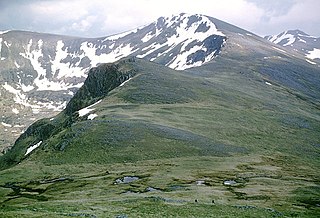
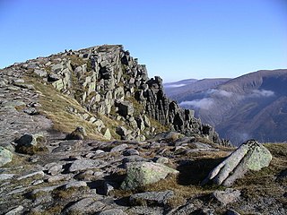
Carn Eighe is a mountain in the Northwest Highlands of Scotland. Rising to 1,183 metres (3,881 ft) above sea level, it is the highest mountain in Scotland north of the Great Glen, the twelfth-highest in the British Isles, and, in terms of relative height, it is the second-tallest mountain in the British Isles after Ben Nevis. Carn Eighe lies between Glen Affric and Loch Mullardoch, and is at the heart of a massif along with its twin peak, the 1,181-metre (3,875 ft) Mam Sodhail.

Beinn a’ Ghlò is a Scottish mountain situated roughly 10 km (6 mi) north east of Blair Atholl in the Forest of Atholl in between Glen Tilt and Glen Loch, in Cairngorms National Park.
The Northwest Highlands are located in the northern third of Scotland that is separated from the Grampian Mountains by the Great Glen. The region comprises Wester Ross, Assynt, Sutherland and part of Caithness. The Caledonian Canal, which extends from Loch Linnhe in the south-west, via Loch Ness to the Moray Firth in the north-east splits this area from the rest of the country. The city of Inverness and the town of Fort William serve as gateways to the region from the south.

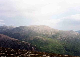
Sgùrr nan Ceathreamhnan is a mountain in the Northwest Highlands of Scotland. It lies between Glen Affric and Glen Elchaig, some 30 kilometres east of Kyle of Lochalsh. With a height of 1,151 metres (3,776 ft) it is classed as a Munro and ranked as the third highest mountain north of the Great Glen.

Mam Sodhail, or Màm Sabhail in Gaelic, sometimes anglicised "Mam Soul", is a mountain with a height of 1,181 metres (3,875 ft) in the Northwest Highlands of Scotland. Classed as a Munro, it is beside Carn Eige in the secluded country on the northern side of Glen Affric, some 30 kilometres east of Kyle of Lochalsh.

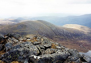
Sgurr na Lapaich is a mountain in the Northwest Highlands of Scotland, situated north of Loch Mullardoch in the high ground that separates Glen Cannich and Glen Strathfarrar. The mountain reaches a height of 1,150 metres, and is the fourth-highest mountain north of the Great Glen. There is no higher ground to the north of it in Great Britain.
Derry Cairngorm is a Scottish mountain in the Cairngorms range, 14 kilometres (8.7 mi) north west of Braemar in the county of Aberdeenshire.

Mòruisg is a Scottish mountain situated in the Glencarron and Glenuig Forest, 10 kilometres south west of the village of Achnasheen in the Highland council area.

The Monadhliath Mountains, or Monadh Liath, are a range of mountains in Scotland. Monadh Liath is Scottish Gaelic, and means "grey mountain range". Running in a northeast to southwest direction, it lies on the western side of Strathspey, to the west of the Cairngorms and to the south east of Loch Ness. Its southwestern limit is usually taken to be Corrieyairack Pass (763m) but similar uplands continue to Glen Roy and Spean Bridge. The range is within the Highland council area, and the south and east fringes are within the Cairngorms National Park. The high point of the range is Càrn Dearg, at 945 metres (3,100 ft), located 40 kilometres (25 mi) south of Inverness. This is one of four Munros in the Monadhliath, the others being A'Chailleach, Geal Chàrn, and Càrn Sgulain. The Monadhliath Mountains are designated a Special Area of Conservation (SAC).
Càrn nan Gobhar is a mountain rising to 993 metres (3,258 ft) in the Northwest Highlands of Scotland. It stands on the northern side of Loch Mullardoch in the upper part of Glen Cannich, in a remote group of four Munros informally known as "The Mullardochs" which form the high ground between Loch Mullardoch and Loch Monar.
The A832 is a road in the Scottish Highlands, linking Cromarty, on the east coast, to Gairloch on the west coast, and beyond Gairloch to Braemore Junction. It is 126 miles (203 km) long and runs entirely in the former county of Ross and Cromarty. The road forms part of the Wester Ross Coastal Trail.

Càrn Mairg is a mountain in the Breadalbane region of the Scottish Highlands, with a height of 1,042 metres (3,419 ft). It stands in a group of four Munro mountains known as the 'Càrn Mairg group', on the north side of Glen Lyon, Perthshire.

Càrn Gorm is a mountain in the Breadalbane region of the Scottish Highlands, with a height of 1,029 metres (3,376 ft). It stands in a group of four Munro mountains known as the Càrn Mairg group or the Glen Lyon Horseshoe, on the north side of Glen Lyon, Perthshire.
Sgòr Gaoith is a mountain peak in the far western massif of the Cairngorms in the Scottish Highlands. It is 1,118 metres (3,668 ft) high, and is the highest point on a long north-south ridge. The ridge is separated from the Braeriach massif to the east by Glen Eanaich and Loch Eanaich.

Beinn Bhuidhe is a mountain near the head of Loch Fyne in Argyll in the Scottish Highlands. It is a Munro with a height of 948 metres (3,110 ft).

Minginish is a peninsula on the Isle of Skye in Scotland. It is situated on the west coast of the island and runs from Loch Scavaig in the south, along the western coast of Skye to Loch Bracadale in the north west, to Loch Harport in the north east, and Glen Sligachan in the south east. It includes most of the peaks of the Cuillin hills including Sgurr Alasdair, the highest point on the island at 992 metres (3,255 ft). The island of Soay lies offshore across the Soay Sound, with the Small Isles further south across the Cuillin Sound.

The Lairig an Laoigh is a mountain pass through the Highlands of Scotland. In speech and sometimes in writing the name is reduced to "Lairig Laoigh". It is of glacial origin, dissecting the Cairngorm plateau, and it runs roughly north–south from Speyside to Deeside at one time being used as a drove road. Between the public road in the Abernethy Forest and the one at Linn of Dee the trekking distance is 31 kilometres (19 mi).

Tom a' Chòinich is a mountain in the Northwest Highlands of Scotland. It is a Munro with a height of 1,112 metres (3,648 ft). Glen Affric is to the south and Loch Mullardoch to the north. Less than 1 kilometre to the west is the 1,032-metre (3,386 ft) Munro Top called Tom a' Chòinich Beag. Its prominence is 149 metres (489 ft) with its parent peak, Càrn Eige, about 4 kilometres (2.5 mi) to the west. This mountain should not be confused with the 955-metre (3,133 ft) Munro Top also called Tom a' Chòinnich near Ben Wyvis.

