Glen Innes, New Zealand

Last updated

Glen Innes
Glen Innes, New Zealand.jpg
Glen Innes, September 2018
Glen Innes, New Zealand
Coordinates: 36°52′34″S174°51′41″E / 36.8762°S 174.8615°E / -36.8762; 174.8615
CountryNew Zealand
City Auckland
Local authority Auckland Council
Electoral ward Maungakiekie-Tāmaki ward
Local board Maungakiekie-Tāmaki Local Board
Board subdivisionTāmaki
Area
[1]
  Land137 ha (339 acres)
Population
 (June 2023) [2]
  Total4,960
Train stations Glen Innes Railway Station
Kohimarama Saint Heliers Glendowie
Saint Johns
Pfeil oben.svg
Pfeil links.svgGlen InnesPfeil rechts.svg
Pfeil unten.svg
Wai o Taiki Bay
Point England Tamaki River

Glen Innes is a suburb in East Auckland, New Zealand, located nine kilometres to the east of the city centre, close to the waters of the Tamaki River estuary.

Contents

Glen Innes was named after a large farm owned by William Innes Taylor in the area. There were four Taylor brothers in Auckland, the sons of a British man who had had a military career in India. Three of the brothers had farms in this area and built houses; William Innes Taylor at Glen Innes, Richard James Taylor at Glendowie and Charles John Taylor at Glen Orchard (now Saint Heliers). [3] Their brother Allan Kerr Taylor had a farm estate in Mount Albert, whose house was called Alberton. [4]

The main streets in Glen Innes are Taniwha Street and Apirana Avenue, which meet in the shopping centre of the suburb. Glen Innes has a train station on the Eastern Line of the Auckland rail network, and is a hub for eastern Auckland isthmus buses (Metrolink).

Glen Innes is a low-income, working class area with around 1,500 state houses. In an effort to improve the quality of state housing in Glen Innes, the government introduced "Talbot Park", an area of higher density housing, consisting of mostly apartment-style housing.

European settlement

The first government sale of land in Tamaki was on 1 February 1842. Allotments were bought for farming by Charles Whybrow Lidgar, John Armitage Buttery, and Patrick Anderson. William Innes Taylor arrived in Auckland in November 1843 made his first purchase of land shortly after. Taylor named the farm the Glen Innes estate. He gradually added to his land holdings and by 1862, Taylor owned around 751 acres. [5] The site Taylor chose for his homestead is now occupied by the Glen Taylor School on West Tamaki Road. Although the homestead is no longer in existence, a Morton Bay fig tree thought to have been planted by Taylor still stands at the entrance of the school. [6] William Innes Taylor died on 7 March 1890. By 1913, 400 acres of the Glen Innes estate had been sold. The land was described as peerless seaside sections. [7]

Demographics

The statistical area of Glen Innes West covers 1.37 km2 (0.53 sq mi) [1] and had an estimated population of 4,960 as of June 2023, [2] with a population density of 3,620 people per km2.

Glen Innes historical population
YearPop.±% p.a.
20063,819    
20133,603−0.83%
20184,413+4.14%
Source: [8]

Glen Innes West had a population of 4,413 at the 2018 New Zealand census, an increase of 810 people (22.5%) since the 2013 census, and an increase of 594 people (15.6%) since the 2006 census. There were 1,212 households, comprising 2,109 males and 2,304 females, giving a sex ratio of 0.92 males per female. The median age was 29.0 years (compared with 37.4 years nationally), with 1,125 people (25.5%) aged under 15 years, 1,149 (26.0%) aged 15 to 29, 1,824 (41.3%) aged 30 to 64, and 315 (7.1%) aged 65 or older.

As of 2013, 39.1% of residents were European/Pākehā, 20.8% were Māori, 40.2% were Pacific peoples, 12.5% were Asian, and 3.6% were other ethnicities. The percentage of people who were born overseas was 33.8, compared with 27.1% nationally. 32.8% had no religion, 49.2% were Christian, 3.1% had Māori religious beliefs, 0.7% were Hindu, 3.5% were Muslim, 2.5% were Buddhist and 1.6% had other religions.

Of those at least 15 years old, 645 (19.6%) people had a bachelor's or higher degree, and 624 (19.0%) people had no formal qualifications. The median income was $25,200, compared with $31,800 nationally. 474 people (14.4%) earned over $70,000 compared to 17.2% nationally. The employment status of those at least 15 was that 1,494 (45.4%) people were employed full-time, 486 (14.8%) were part-time, and 237 (7.2%) were unemployed. [8]

Education

Tamaki College is a secondary school (years 9-13) with a roll of 694. [9]

Glen Innes School is a full primary school (years 1-8) with a roll of 150. [10]

St Pius X Catholic School is a state-integrated full primary school with a roll of 107. [11]

Sacred Heart College is a state-integrated Catholic boys' school (years 7-13) with a roll of 1286. [12]

Te Kura Kaupapa Māori o Pūau Te Moananui-ā-Kiwa is a composite school (years 1-13) with a roll of 102. [13] It teaches primarily in the Māori language.

All these schools are coeducational. Rolls are as of April 2023. [14]

Te Ara Rama Matariki Light Trail

Since 2013, the annual Te Ara Rama Matariki Light Trail has been hosted in Glen Innes in celebration of Matariki, the Māori new year. [15] It is an outdoor public lighting festival that runs throughout Maybury Reserve, and typically takes place over nine nights, representing the nine stars of Matariki. [16] On the final night, a large fireworks display takes place.

Redevelopment conflict

There have been protests in Glen Innes over proposals to redevelop existing state-owned housing. [17] Housing New Zealand plans to replace houses on large sections with more "intensive development", including many conversions to privately owned and sold housing with profits going to developers such as property mogul, Murdoch Dryden.[ citation needed ] This involves removing tenants from properties some have lived in for long periods. There has been a number of reported deaths of elderly tenants from during the relocation process.[ citation needed ] Many protests have resulted in arrests of demonstrators, including Mana Party MP Hone Harawira on one occasion, as well as a number of reported police brutality cases. [18] Housing New Zealand argues that the development will "make better use of land" and enable the provision of higher quality homes to their tenants, however community members argue it is a gentrification process which is tearing apart their community. [19]

Notable people

Panmure-Glen Innes industrial area

The area to the southwest of Glen Innes is primarily industrial.

The statistical area called Panmure Glen Innes Industrial covers 2.01 km2 (0.78 sq mi) [1] and had an estimated population of 340 as of June 2023, [2] with a population density of 169 people per km2.

Panmure-Glen Innes industrial area historical population
YearPop.±% p.a.
2006153    
2013252+7.39%
2018321+4.96%
Source: [20]

Panmure Glen Innes Industrial had a population of 321 at the 2018 New Zealand census, an increase of 69 people (27.4%) since the 2013 census, and an increase of 168 people (109.8%) since the 2006 census. There were 51 households, comprising 192 males and 129 females, giving a sex ratio of 1.49 males per female. The median age was 33.6 years (compared with 37.4 years nationally), with 24 people (7.5%) aged under 15 years, 108 (33.6%) aged 15 to 29, 165 (51.4%) aged 30 to 64, and 21 (6.5%) aged 65 or older.

As of the 2013 census, 35.5% were European/Pākehā, 23.4% were Māori, 21.5% were Pacific peoples, 27.1% were Asian, and 4.7% were other ethnicities. The percentage of people who were born overseas was 44.9%, compared with 27.1% nationally. 31.8% had no religion, 43.9% were Christian, 4.7% had Māori religious beliefs, 6.5% were Hindu, 4.7% were Muslim, 1.9% were Buddhist and 3.7% were other religions.

Of those at least 15 years old, 57 (19.2%) people had a bachelor's or higher degree, and 33 (11.1%) people had no formal qualifications. The median income was $26,700, compared with $31,800 nationally. 30 people (10.1%) earned over $70,000 compared to 17.2% nationally. The employment status of those at least 15 was; 153 (51.5%) people were employed full-time, 42 (14.1%) were part-time employed, and 21 (7.1%) were unemployed. [20]

Related Research Articles

<span class="mw-page-title-main">Mount Wellington, New Zealand</span> Suburb in Auckland, New Zealand

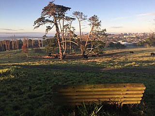
Mount Wellington is a suburb in East Auckland, New Zealand, located 10 kilometres southeast of the city centre. It is surrounded by the suburbs of Stonefields, Tamaki, Panmure, Penrose, and Ellerslie, and by the Tamaki River. The suburb is named after the volcanic peak of Maungarei / Mount Wellington. Sylvia Park is a large business park and shopping centre located in the suburb.

<span class="mw-page-title-main">Howick, New Zealand</span> Suburb in Auckland, New Zealand

Howick is a suburb of East Auckland, New Zealand. The area was traditionally settled by Ngāi Tai ki Tāmaki, and in 1847 Howick was established as a defensive settlement for Auckland, by veteran fencible soldiers of the British Army. Howick was a small agricultural centre until the 1950s, when it developed into a suburban area of Auckland. Modern Howick draws much of its character from the succeeding waves of Asian settlement that it has experienced since New Zealand's immigration reforms of the 1980s, with a strong Chinese New Zealander presence in the suburb's business and education sectors.

<span class="mw-page-title-main">Tāmaki</span> Suburb in Auckland, New Zealand

Tāmaki is a small suburb of East Auckland, 11 kilometres from the Auckland CBD, in the North Island of New Zealand. It is located by the banks of the estuarial Tāmaki River, which is a southern arm of the Hauraki Gulf. The suburb is between the suburbs of Point England to the north and Panmure to the south.

<span class="mw-page-title-main">Panmure, New Zealand</span> Suburb in Auckland, New Zealand

Panmure is an east Auckland suburb, in the North Island of New Zealand. It is located 11 kilometres southeast of the Auckland CBD, close to the western banks of the Tāmaki River and the northern shore of the Panmure Basin. To the north lies the suburb of Tāmaki, and to the west is the cone of Maungarei / Mount Wellington.

<span class="mw-page-title-main">Mount Albert, New Zealand</span> Suburb in Auckland, New Zealand

Mount Albert is an inner suburb of Auckland, New Zealand, which is centred on Ōwairaka / Mount Albert, a local volcanic peak which dominates the landscape. By 1911, growth in the area had increased to the point where Mount Albert was declared an intdependent borough, which was later absorbed into Auckland. The suburb is located 7 kilometres (4.3 mi) to the southwest of the Auckland City Centre.

<span class="mw-page-title-main">Māngere</span> Suburb in Auckland, New Zealand

Māngere is a major suburb in South Auckland, New Zealand, located on mainly flat land on the northeastern shore of the Manukau Harbour, to the northwest of Manukau City Centre and 15 kilometres south of the Auckland city centre. It is the location of Auckland Airport, which lies close to the harbour's edge to the south of the suburb.

<span class="mw-page-title-main">Pakuranga</span> Suburb in Auckland, New Zealand

Pakuranga is an eastern suburb of Auckland, in northern New Zealand. Pakuranga covers a series of low ridges and previously swampy flats, now drained, that lie between the Pakuranga Creek and Tamaki River, two estuarial arms of the Hauraki Gulf. It is located to the north of Manukau and 15 kilometres southeast of the Auckland CBD.

<span class="mw-page-title-main">Bucklands Beach</span> Suburb in Auckland, New Zealand

Bucklands Beach is a suburb 13 kilometres (8.1 mi) east of Auckland's CBD in New Zealand. The suburb is in the Howick ward, one of the thirteen administrative divisions of Auckland Council.

<span class="mw-page-title-main">Glendowie, New Zealand</span> Suburb in Auckland, New Zealand

Glendowie is a suburb in Auckland, New Zealand. It is under the local governance of Auckland Council. It was under Auckland City Council from 1989 until the merger of all of Auckland's councils into the "super city" in 2010.

<span class="mw-page-title-main">East Tāmaki</span> Suburb in Auckland, New Zealand

East Tāmaki is a suburb of Auckland, New Zealand. It is a largely industrial area adjacent to a rapidly growing population. Prior to the 1960s it was largely a dairy farming area. A landmark is Smales Mountain which in 2010 has the remains of an old Pa, a stone field garden, an early church, and farm homestead. A newer landmark is the Fo Guang Shan Temple which was the largest Buddhist temple in New Zealand when it opened in 2007.

<span class="mw-page-title-main">Farm Cove, New Zealand</span> Suburb in Auckland, New Zealand

Farm Cove is a suburb located in East Auckland, New Zealand. The suburb is in the Howick ward, one of the thirteen administrative divisions of Auckland. The Rotary Walkway Reserve runs through Farm Cove.

<span class="mw-page-title-main">Ōtāhuhu</span> Suburb in Auckland, New Zealand

Ōtāhuhu is a suburb of Auckland, New Zealand – 13 kilometres (8.1 mi) to the southeast of the CBD, on a narrow isthmus between an arm of the Manukau Harbour to the west and the Tāmaki River estuary to the east. The Auckland isthmus is the narrowest connection between the North Auckland Peninsula and the rest of the North Island, being only some 1,200 metres (3,900 ft) wide at its narrowest point, between the Ōtāhuhu Creek and the Māngere Inlet. As the southernmost suburb of the former Auckland City, it is considered part of South Auckland.

<span class="mw-page-title-main">Point England</span> Suburb in Auckland, New Zealand

Point England is a suburb of Auckland, New Zealand. It is under the local governance of the Auckland Council.

<span class="mw-page-title-main">Glen Eden, New Zealand</span> Suburb of Auckland, New Zealand

Glen Eden is a suburb of West Auckland, New Zealand, located at the foothills of Waitākere Ranges. Originally known as Waikumete, the suburb gained the name Glen Eden in 1921. The suburb is in the Waitākere Ward, one of the thirteen administrative areas of Auckland governed by Auckland Council.

<span class="mw-page-title-main">Wai o Taiki Bay</span> Suburb in Auckland, New Zealand

Wai o Taiki Bay is a suburb in Auckland, New Zealand. It is under the local governance of Auckland Council.

<span class="mw-page-title-main">Saint Heliers</span> Suburb in Auckland, New Zealand

Saint Heliers is an affluent seaside suburb of Auckland with a population of 11,570 as of June 2023. This suburb is popular amongst visitors for the beaches, cafés, and views of Rangitoto Island, the distinctive volcanic island in the Hauraki Gulf.

<span class="mw-page-title-main">East Auckland</span> Region of Auckland, New Zealand

East Auckland is one of the major geographical regions of Auckland, the largest city in New Zealand. Settled in the 14th century, the area is part of the traditional lands of Ngāi Tai ki Tāmaki. The area was developed into farmland in the 1840s, and the town of Howick was established as a defensive outpost by fencibles to protect Auckland. Coastal holiday communities developed in the area from the 1910s, and from the 1950s underwent major redevelopment into a suburban area of greater Auckland. From the 1980s, the area saw significant Asian New Zealander migrant communities develop.

<span class="mw-page-title-main">Riverhead, New Zealand</span> Place in Auckland Region, New Zealand

Riverhead is a small, historically predominantly working-class town located at the head of the Waitematā Harbour in the north-west of Auckland, New Zealand. The region around Riverhead and the neighbouring towns of Kumeu and Huapai is known for its vineyards. This town has had its 15 minutes in the spotlight appearing in movies Bridge to Terabithia and Crooked Earth and the odd television show such as Outrageous Fortune. The region features a pine plantation forest that is popular with horse riders, mountain bikers and motorcyclists. Riverhead Forest is operated by Matariki Forests, under Crown Licence. The forest was originally planted on poor kauri gum fields.

<span class="mw-page-title-main">Half Moon Bay, Auckland</span> Suburb in Auckland, New Zealand

Half Moon Bay, is a suburb of East Auckland, New Zealand, lying immediately south of Bucklands Beach. It is home to the Half Moon Bay Marina, where over 500 boats berth. It is located on the Tāmaki River in the Hauraki Gulf.

<span class="mw-page-title-main">Ōtara</span> Suburb in Auckland, New Zealand

Ōtara is a suburb of South Auckland, New Zealand, situated 18 kilometres to the southeast of the Auckland City Centre. Ōtara lies near the head of the Tamaki River, and is surrounded by the suburbs of Papatoetoe, East Tāmaki, Clover Park and Flat Bush. The area is traditionally part of the rohe of Ngāi Tai ki Tāmaki, and the name Ōtara refers to Ōtara Hill / Te Puke ō Tara, a former Ngāi Tai ki Tāmaki pā and volcanic hill to the north of the suburb. From 1851 to 1910 the area was part of the Goodfellow family farm, and during the 1910s the area was an agricultural college run by the Dilworth Trust.

References

  1. 1 2 3 "ArcGIS Web Application". statsnz.maps.arcgis.com. Retrieved 21 July 2022.
  2. 1 2 3 "Population estimate tables - NZ.Stat". Statistics New Zealand . Retrieved 25 October 2023.
  3. Stacpoole, John. "Allan Kerr Taylor". Dictionary of New Zealand Biography . Ministry for Culture and Heritage . Retrieved 11 April 2017.
  4. "Alberton". Heritage New Zealand – heritage.org.nz. Retrieved 10 April 2017.
  5. Jackson, Elizabeth T (1976). Delving into the past of Auckland's eastern suburbs. Section 7 : Glendowie. Section 8 : Glen Innes. Elizabeth Jackson. p. 1.
  6. "Our history". Glen Taylor School. Retrieved 16 August 2021.
  7. "Glen Innes, Tamaki West ...to be sold by public auction". Auckland Museum . Retrieved 16 August 2021.
  8. 1 2 "Statistical area 1 dataset for 2018 Census". Statistics New Zealand. March 2020. Glen Innes West (144700). 2018 Census place summary: Glen Innes West
  9. Education Counts: Tamaki College
  10. Education Counts: Glen Innes School
  11. Education Counts: St Pius X Catholic School
  12. Education Counts: Sacred Heart College
  13. Education Counts: Te KKM o Puau Te Moananui-a-Kiwa
  14. "New Zealand Schools Directory". New Zealand Ministry of Education. Retrieved 12 December 2022.
  15. PRIESTLEY, LAUREN (2 July 2013). "Stars in his eyes". Stuff. Retrieved 24 July 2023.
  16. "ABOUT US". matarikigi. Retrieved 24 July 2023.
  17. "State housing tenants march on Parliament". 3 News. 7 November 2012. Retrieved 8 January 2014.
  18. "State house redevelopment protests criticised". 12 October 2012. Retrieved 8 January 2014.
  19. "Northern Glen Innes redevelopment to provide homes to those in need". August 2013. Retrieved 8 January 2014.
  20. 1 2 "Statistical area 1 dataset for 2018 Census". Statistics New Zealand. March 2020. Panmure Glen Innes Industrial (145400). 2018 Census place summary: Panmure Glen Innes Industrial