Glen Park, San Francisco

Last updated
Glen Park
On Diamond Street by Bosworth, looking North, Glen Park, SF.jpg
View of Glen Park from Diamond Street by Bosworth Street.
Location map San Francisco County.png
Red pog.svg
Glen Park
Location within San Francisco
Coordinates: 37°44′02″N122°26′00″W / 37.73389°N 122.43333°W / 37.73389; -122.43333
Country Flag of the United States (23px).png  United States
State Flag of California.svg  California
City-county San Francisco
Government
   Supervisor Rafael Mandelman [1]
   Assemblymember Matt Haney (D) [2]
   State Senator Scott Wiener (D) [2]
   U. S. Rep. Nancy Pelosi (D) [3]
Area
[4]
  Total1.26 km2 (0.485 sq mi)
  Land1.26 km2 (0.485 sq mi)
Population
 (2008) [4]
  Total6,979
  Density5,559/km2 (14,397/sq mi)
ZIP Code
94131
Area codes 415/628

Glen Park is a residential neighborhood in San Francisco, California, located south of Twin Peaks and adjacent to Glen Canyon Park.

Contents

Geography

The Glen Park BART station at Bosworth Glen Park station from Bosworth Street, January 2006.jpg
The Glen Park BART station at Bosworth

The neighborhood is nestled at the southeastern edge of San Francisco's central hills, the San Miguel Range. It includes Gold Mine Hill, a portion of Fairmount Hill to the east, Martha Hill to the south, as well as their southern- and eastern-facing slopes. The neighborhood's streets follow the hill's contours to a small commercial district ("the Village") at the intersection of Chenery and Diamond streets.

As defined by the San Francisco Planning Department, the neighborhood borders Diamond Heights to the northwest, along Diamond Heights Boulevard; Noe Valley to the north, along 30th Street; Bernal Heights to the east, along San Jose Avenue; and Outer Mission to the south, along Bosworth Street. (The San Francisco Association of Realtors draws a wider southwestern boundary and calls the adjacent neighborhood Sunnyside.) Historically, the area bordered by 30th Street, the peak of Fairmount Hill, Castro Street, and San Jose Avenue has been known as Fairmount Heights. [5]

The Glen Park neighborhood consists of residential, commercial, and "public" city planning zones, specifically the following zones: [6] [7] [8]

To the west, upper Islais Creek, historically the largest creek in San Francisco, still flows above ground through Glen Canyon from the southern slopes of Twin Peaks. It is only one of two San Francisco creeks (the other being Lobos Creek) to still do so. Today, Islais Creek flows into an underground culvert near the Glen Canyon Park Recreation Center, following its historic route through the Glen Park neighborhood parallel to Chenery and Bosworth (today under the Glen Park Greenway) on its way to San Francisco Bay. Organizations such as the San Francisco Planning and Urban Research Association have proposed to daylight it.

History and characteristics

Glen Park Glen Park, San Francisco.jpg
Glen Park

The first named streets in Glen Park were mapped in 1872 on land that had been occupied by milch rancher (i.e., dairy farmer) George Ulshofer as early as 1859 or 1860. [10] The route of the Old San Jose Road through the district (also known as the El Camino Real) would become the future streets of Diamond and Chenery, so the route was already well known and well traveled. [11]

In 1897, realtor Archibald S. Baldwin of the agency Baldwin & Howell had a plan for developing a new residential district. While the remote district had been made more accessible with the opening of the San Francisco and San Mateo Electric Railway in 1892 by Behrend Joost (to bring residents to his new Sunnyside residential district just to the south), Baldwin needed an enticement to attract potential buyers to the region. Baldwin owned some of the lands in the district and also managed adjacent lands for the Crocker Estate. [12]

It was Baldwin who came up with the name of "Glen Park" for the district. [12] The first use of “Glen Park” was when Baldwin announced the organization of the Glen Park Company in 1897, with the sole purpose of opening and managing a zoological gardens. His 145-acre pleasuring grounds and zoo became known as Glen Park and the Mission Zoo. [13] Opening in 1898, it attracted 8,000 to 15,000 people each weekend for its vaudeville shows, daring aeronautic displays, sporting events, and animal exhibits. In 1899 with the pleasuring grounds a success, Baldwin began auctioning his home lots, Glen Park Terrace, located along Glen Avenue (today's Chenery Street between Diamond and Elk Streets). Because of difficulties encountered in the management of Glen Park and the Mission Zoo, as well as weak sales of Glen Park Terrace home lots, Baldwin divested all of his holdings in 1901, with much of the land being transferred to the California Title Company and the Crocker Estate. The Crocker Estate would continue to manage the main grounds of Glen Park and the Mission Zoo in today's Glen Canyon as a private picnic and pleasuring grounds until 1922, when the land was finally transferred to the City and County of San Francisco. They began releasing home lots surrounding Glen Canyon after the San Francisco Earthquake in 1906, when the population of Glen Park exploded with new residents who had been displaced by the catastrophe.

Transit through Glen Park began when the San Francisco and San Mateo Electric Railway opened access to southern areas of the city. Transit was improved further in 1916, when the SF & SM was acquired by the San Francisco Municipal Railway. A branch of the San Francisco Public Library opened in 1927. Today, transit is provided by the Glen Park BART station, the J Church line of the Muni Metro, and several Muni bus lines. Interstate 280 is also nearby.

Because of Glen Park's small size and mom and pop businesses, the neighborhood is sometimes described as having a village atmosphere. [14] A multi-use, urban infill project opened in 2006, anchored by a natural foods grocery and a new branch library. [15] Public spaces include Walter Haas Playground, Billy Goat Hill Park, and Fairmount Plaza.

See also

Related Research Articles

<span class="mw-page-title-main">Noe Valley, San Francisco</span> Neighborhood in San Francisco, California, United States

Noe Valley is a neighborhood in the central part of San Francisco, California. It is named for Don José de Jesús Noé, noted 19th-century Californio statesman and ranchero, who owned much of the area and served as mayor.

<span class="mw-page-title-main">West Hills, Los Angeles</span> Neighborhood in Los Angeles, California, United States

West Hills is an affluent residential community in the western San Fernando Valley region of the City of Los Angeles, California. The percentage of residents aged 35 and older is among the highest in Los Angeles County.

<span class="mw-page-title-main">Glen Canyon Park</span> Park in San Francisco, California, USA

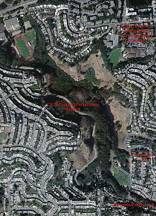
Glen Canyon Park is a city park in San Francisco, California. It occupies about 70 acres (28 ha) along a deep canyon adjacent to the Glen Park, Diamond Heights, and Miraloma Park neighborhoods. O'Shaughnessy Hollow is a rugged, undeveloped 3.6 acres (1.5 ha) tract of parkland that lies immediately to the west and may be considered an extension of Glen Canyon Park.

City Heights is a dense urban community in central San Diego, California, known for its ethnic diversity. The area was previously known as East San Diego. City Heights is located south of Mission Valley and northeast of Balboa Park.

<span class="mw-page-title-main">San Bruno Mountain</span> Mountain in California, United States

San Bruno Mountain is a fault-block horst in northern San Mateo County, California; its northern slopes rise in San Francisco. It is surrounded by San Francisco Bay and the cities of Brisbane, Colma, Daly City, and South San Francisco, and has played an important role in the history of all these communities.

<span class="mw-page-title-main">Diamond Heights, San Francisco</span> Neighborhood of San Francisco

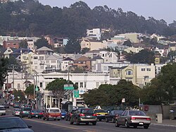
Diamond Heights is a neighborhood in central San Francisco, California, roughly bordered by Diamond Heights Boulevard and Noe Valley to the north and east and Glen Canyon Park to the south and west. It is built on three hills: Red Rock Heights on the northwest, Gold Mine Hill in center, and Fairmount Heights on the southeast.

<span class="mw-page-title-main">Claremont, Oakland/Berkeley, California</span> Place in California, United States

The Claremont district is a neighborhood straddling the city limits of Oakland and Berkeley in the East Bay section of the San Francisco Bay Area in California, United States. The main thoroughfares are Claremont and Ashby Avenues.

<span class="mw-page-title-main">Rincon Hill, San Francisco</span> Neighborhood of San Francisco

Rincon Hill is a neighborhood in San Francisco, California. It is one of San Francisco's many hills, and one of its original "Seven Hills". The relatively compact neighborhood is bounded by Folsom Street to the north, the Embarcadero to the east, Bryant Street on the south, and Essex Street to the west. Named after Rincon Point that formerly extended into the bay there, Rincon Hill is located just south of the Transbay development area, part of the greater South of Market area. The hill is about 100 feet tall.

<span class="mw-page-title-main">Parkside, San Francisco</span> Neighborhood in San Francisco, California, United States

The Parkside is a neighborhood in the western part of San Francisco, California, usually considered to be part of the Sunset District. It is located in the southern part of the Avenues south of Quintara and north of Sloat Boulevard.

The city of San Antonio in the U.S. state of Texas is composed of a number of neighborhoods and districts, spreading out surrounding the central Downtown Area.

<span class="mw-page-title-main">Islais Creek</span> River in the United States of America

Islais Creek or Islais Creek Channel is a small creek in San Francisco, California. The name of the creek is derived from a Salinan Native American word "slay" or "islay", the name for the Prunus ilicifolia wild cherries. Around the time of the Gold Rush, the area became an industrial hub, and the condition of the creek worsened. After the devastating 1906 San Francisco earthquake, the city decided to reclaim the creek using earthquake debris, reducing the waterbody to its present size. Though much of Islais Creek has been converted to an underground culvert, remnants still exist today at both Glen Canyon Park and Third Street. Several community organizations are dedicated to preserve these remnants, as they are important wildlife habitats.

Rancho Rincón de las Salinas y Potrero Viejo was a 4,446-acre (17.99 km2) Mexican land grant, largely within present day southeastern San Francisco, California, and extending to San Mateo County, California.

Fairmount Park is a neighborhood of San Diego, California. Its borders are defined by Interstate 15 to the west, Interstate 805 to the east and California Highway 94 to the south. Its neighboring communities are South Park and Golden Hill to the west, Azalea Park and City Heights to the east, and Webster to the south. It is primarily residential, mostly single-family homes, with a small commercial area along Home Avenue including several restaurants and convenience stores. Bayridge is a small neighborhood within Fairmount Park on its westernmost knoll, identifiable by its outstanding views and well-maintained townhouse development. Fairmount Park is 3 miles from Downtown San Diego. Chollas Creek runs through it.

<span class="mw-page-title-main">Potrero Point</span> District in southeast San Francisco, California

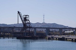
Potrero Point is an area in San Francisco, California, east of San Francisco's Potrero Hill neighborhood. Potrero Point was an early San Francisco industrial area. The Point started as small natural land feature that extends into Mission Bay of San Francisco Bay. The Point was enlarged by blasted and cuts on the nearby cliffs. The cut material was removed and used to fill two square miles into the San Francisco bay, making hundreds of acres of flat land. The first factories opened at Potrero Point in the 1860s. Early factories were powder magazine plant, the Pacific Rolling Mill Company and small shipyards. The large Union Iron Works and its shipyards were built at the site, stated in 1849 by Peter Donahue. To power the factories and neighborhood coal and gas-powered electricity works were built, later the site became Pacific Gas and Electric Company (PG&E).

References

  1. "Mandelman ousts incumbent Sheehy in SF's District Eight". San Francisco Chronicle. SF Chronicle. 6 June 2018. Retrieved May 26, 2020.
  2. 1 2 "Statewide Database". UC Regents. Archived from the original on February 1, 2015. Retrieved December 29, 2014.
  3. "California's 11th Congressional District - Representatives & District Map". Civic Impulse, LLC.
  4. 1 2 "Glen Park neighborhood in San Francisco, California (CA), 94131 subdivision profile - real estate, apartments, condos, homes, community, population, jobs, income, streets".
  5. "Origins of Fairmount Heights: Foundations in Railroad, Civil War, and Real Estate Histories". Glen Park Neighborhoods History Project. December 2019. Retrieved January 22, 2020.
  6. "Zoning Use Districts". San Francisco Planning. October 16, 2020. Retrieved September 9, 2021.
  7. San Francisco Planning (April 2020). "Zoning Use District Maps". American Legal Publishing. Retrieved September 9, 2021.
  8. Glen Park Association (October 2018). "Zoning Use District Maps". Glen Park Association. Retrieved September 9, 2021.
  9. "SEC. 756. GLEN PARK NEIGHBORHOOD COMMERCIAL TRANSIT DISTRICT". American Legal Publishing. July 30, 2021. Retrieved September 9, 2021.
  10. "George Ulshofer and the First Named Streets of Glen Park". Glen Park Neighborhoods History Project. June 15, 2015. Retrieved January 20, 2020.
  11. "The Old Mission Road & Chenery, Diamond, Arlington, and Wilder Streets: Among the Oldest Thoroughfares in San Francisco?". Glen Park Neighborhoods History Project. Summer 2017. Retrieved January 20, 2020.
  12. 1 2 "The First Use of "Glen Park" in the Old Rancho San Miguel". Glen Park Neighborhoods History Project. December 28, 2016. Retrieved January 20, 2020.
  13. "The San Francisco Mission Zoo: Wilder Days in Glen Park (Part I)". Tramps of San Francisco. September 3, 2012. Retrieved January 20, 2020.
  14. Morse, Rob (November 13, 1985). "Rob Morse, Standing Tall". The San Francisco Examiner. p. 43. Retrieved January 22, 2019.
  15. "San Francisco Public Library | Home | San Francisco Public Library".