
Huntly is a town in the Waikato district and region of the North Island of New Zealand. It was on State Highway 1, 95 kilometres (59 mi) south of Auckland and 32 kilometres (20 mi) north of Hamilton. It is situated on the North Island Main Trunk (NIMT) railway and straddles the Waikato River. Huntly is within the Waikato District which is in the northern part of the Waikato region local government area.

Waiuku is a rural town in the Auckland Region of New Zealand. It is located at the southern end of the Waiuku River, which is an estuarial arm of the Manukau Harbour, and lies on the isthmus of the Āwhitu Peninsula, which extends to the northeast. It is 40 kilometres southwest of Auckland city centre, and 12 kilometres north of the mouth of the Waikato River.

Tuakau is a town in the Waikato region at the foot of the Bombay Hills, formerly part of the Franklin District until 2010, when it became part of Waikato District in the North Island of New Zealand. The town serves to support local farming, and is the residence of many employees of New Zealand Steel at Glenbrook.

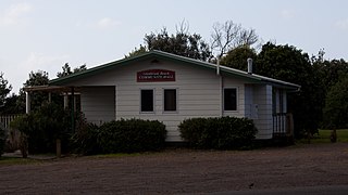
Pōrangahau, a township close to the Pacific Ocean coast in the south-east of the North Island of New Zealand, has a very small population. It lies in the southernmost part of Hawke's Bay, 45 kilometres south of Waipukurau, and close to the mouth of the Porangahau River. The settlement includes a marae and a school.

Te Papapa is a suburb of Auckland, New Zealand. It is located nine kilometres to the southeast of Auckland city centre, on the northern shore of Māngere Inlet, an arm of the Manukau Harbour. The residential and light-industrial suburb lies between the suburbs of Onehunga, Penrose, and Southdown, and is at the northern end of the Māngere Bridge which connects it with the South Auckland suburb of Māngere. Train services on the Onehunga Line run through the suburb on the Onehunga Branch line, which reopened in 2010. Services at Te Papapa station commenced on 19 September 2010. Carter Holt Harvey's head office is located at 173 Captain Springs Road in the Te Papapa area. It has been suggested that the name of the suburb refers to a fortress built of rock slabs. However, at the time Te Papapa Railway Station first opened the area around was commonly known as "Pumpkin Flat" and a short article in the Auckland Star reported that the general manager of the railways had chosen to name the station after the "Maori long pumpkin or Te Papapa" in remembrance of the commonly used name.

Manurewa is a major suburb in South Auckland, New Zealand, located 6 km (3.7 mi) south of Manukau Central, and 26 km (16 mi) southeast of the Auckland City Centre. It is home to the Auckland Botanic Gardens, which receives over a million visitors a year. Manurewa has a high proportion of non-European ethnicities, making it one of the most multi-cultural suburbs in New Zealand. Employment for many is at the many companies of nearby Wiri, Papakura, and at the steel mill at Glenbrook.

Piha is a coastal settlement in West Auckland, on the western coast of the Auckland Region in New Zealand. It is one of the most popular beaches in the area and a major day-trip destination for Aucklanders throughout the year, and especially in summer.

Kaukapakapa is a town in the North Island of New Zealand. It is situated in the Rodney ward of the Auckland Region and is around 50 kilometres northwest of Auckland city. State Highway 16 passes through the town, connecting it to Helensville about 12 km to the south-west, and Araparera about 14 km to the north. The North Auckland Line also passes through Kaukapakapa. The Kaukapakapa River flows from the town to the Kaipara Harbour to the west.
Leigh is a small coastal community in the north of the Auckland Region of New Zealand. It lies on the west side of Omaha Cove, a small inlet within Ōmaha Bay to the south of Cape Rodney. It is 13 km from Matakana, 21 km from Warkworth and approximately 92 km north of Auckland City.

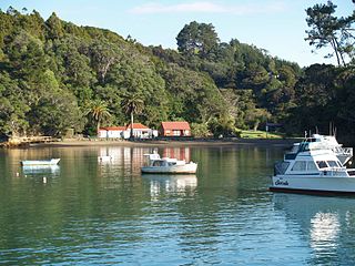
Opua is a locality in the Bay of Islands, in the sub-tropical Northland Region of New Zealand. It is notable as the first port for overseas yachts arriving in the country after crossing the Pacific Ocean. In the original 1870s plans for the town, it was named Newport. The town of Paihia is nearby, and the small settlement of Te Haumi is in between.
Ōkaihau is a small town in the Northland Region of New Zealand's North Island, just north of Kaikohe. State Highway 1 passes through Ōkaihau making it fairly busy. Ōkaihau has a primary school and a secondary school.

Normanby is a small village in South Taranaki, New Zealand. It is approximately 6 km inland from Hāwera along State Highway 3. Eltham is 13 km further north.
Taharoa is a small village on the west coast of the North Island of New Zealand, to the southwest of Kawhia Harbour and overlooking Lake Taharoa.

Mangawhai is a township at the south-west extent of the Mangawhai Harbour, or Mangawhai Estuary, in Northland, New Zealand. The adjacent township of Mangawhai Heads is 5 km north-east, on the lower part of the harbour. Kaiwaka is 13 km south-west, and Waipu is 20 km north-west of Mangawhai Heads.
Tauhoa is a rural community in the Auckland Region of New Zealand's North Island.
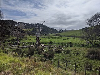
Onewhero is a village and rural community in the Waikato District and Waikato region of New Zealand's North Island.
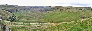
Te Ākau is a small farming settlement in the North Island of New Zealand, located 62 km (39 mi) north west of Hamilton, 39 km (24 mi) south west of Huntly, 45 km (28 mi) south of Port Waikato and 47 km (29 mi), or 19 km (12 mi) by ferry and road, north of Raglan. It has a hall and a school.
Kapiro is a locality in the Far North District of Northland, New Zealand. State Highway 10 passes through Kapiro. Waipapa is 2.7 km south, and Kaeo is 19 km northwest, by road.
Waipatukahu is a locality west of Auckland, in New Zealand. It surrounds Waipatukahu Stream, which flows north-north-east from Lake Paekawau, draining the Waimauku Plateau and the Western Sand Country and joins the Kaipara River.
Glenbrook Beach is a rural community at the northern end of a peninsula formed between the Waiuku River and Taihiki River in Auckland, New Zealand. Waiuku is 14 km south by road.

