
County Donegal is a county of Ireland in the province of Ulster and in the Northern and Western Region. It is named after the town of Donegal in the south of the county. It has also been known as County Tyrconnell or Tirconaill, after the historic territory. Donegal County Council is the local council and Lifford is the county town.

Lifford is the county town of County Donegal, Ireland, the administrative centre of the county and the seat of Donegal County Council, although the town of Letterkenny is often mistaken as holding this role.

Clondalkin is a suburban town in County Dublin, 10 km (6 mi) west of Dublin city centre, Ireland, under the administrative jurisdiction of South Dublin. It features an 8th-century round tower that acts as a focal point for the area.

Schull or Skull is a town on the south-west coast of County Cork in Ireland.

Buncrana is a town in County Donegal, Ireland. It is beside Lough Swilly on the Inishowen peninsula, 23 kilometres (14 mi) northwest of Derry and 43 kilometres (27 mi) north of Letterkenny. In the 2022 census, the population was 6,971, making it the second most populous town in County Donegal, after Letterkenny, and the largest in Inishowen.

Milford or Millford, historically called Ballynagalloglagh, is a small town and townland in County Donegal, Ireland. The population at the 2022 census was 1,076.

Gweedore is a Gaeltacht (Irish-speaking) district and parish located on the Atlantic coast of County Donegal in the north-west of Ireland. Gweedore stretches some 26 kilometres (16 mi) from Glasserchoo and Bloody Foreland in the north to Crolly in the south and around 14 kilometres (9 mi) from Dunlewey in the east to Magheraclogher and Magheralosk in the west, and is sometimes described as one of Europe's most densely populated rural areas. It is the largest Irish-speaking parish in Ireland with a population of around 4,065, and is also the home of the northwest regional studios of the Irish-language radio service RTÉ Raidió na Gaeltachta, as well as an external campus of the University of Galway. Gweedore includes the settlements of Brinlack, Bunbeg, Derrybeg, Crolly and Dunlewey, and sits in the shade of County Donegal's highest peak, Errigal.

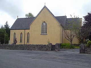
Muff is a village, civil parish and townland in County Donegal, Ireland. It is near the mouth of the River Foyle and sits close to the border between the Republic of Ireland and Northern Ireland. The village of Culmore and the city of Derry are to the south in Northern Ireland.

Rosmuc or Ros Muc, sometimes anglicised as Rosmuck, is a village in the Conamara Gaeltacht of County Galway, Ireland. It lies halfway between the town of Clifden and the city of Galway. Irish is the predominant spoken language in the area, with the electoral division of Turlough, Rosmuc, representing one of the highest percentages of Irish-speaking people in the country. The townland of Rosmuck is part of the civil parish of Kilcummin.

Clane is a town in County Kildare, Ireland, 35.4 km (22 mi) from Dublin. With a population of 8,152 in 2022, it is the ninth largest town in Kildare and the 66th largest in Ireland. The town is on the River Liffey. Clane gives its name to the associated townland, civil parish, electoral division and surrounding barony.

Anagaire is a village in The Rosses district of County Donegal, Ireland. As of 2016, the population was 236.

Quigley's Point is a village in County Donegal, Ireland. Located on the eastern shores of Inishowen and overlooking Lough Foyle, the village is sometimes known locally as "Carrowkeel" as it is in a townland of that name. To the south is the city of Derry and to the north lie the villages of Moville and Greencastle. A car ferry links Greencastle with Magilligan during the summer. The river Cabry, which flows through the area, is spanned by a late-18th century bridge at Quigley's Point.

Campile is a small village situated in County Wexford in the south of Ireland. It is 14 kilometres south of the town of New Ross. As of the 2016 census, Campile had a population of 448 people.
Meelick is a small village and townland in County Clare, Ireland, situated a few kilometres north of Limerick city in the Mid-West Region.

Loch an Iúir, anglicised as Loughanure, is a village and townland in The Rosses, a district in the west of County Donegal in Ulster, the northern province in Ireland. The village is in the Gaeltacht, being halfway between Gweedore and Dungloe, with the N56 road passing through the village. According to the 2016 census, 37% of the population spoke Irish on a daily basis outside the education system. The village of Loughanure lies within the Barony of Boylagh.

Staplestown is a village and townland in north County Kildare, Ireland, located 40 kilometres west of Dublin. The village has a church, a school and is home to St Kevin's GAA. The local national (primary) school is Scoil Naomh Mhuire National School.
Bridgend or Bridge End is a village in County Donegal, Ireland, at the base of the Inishowen peninsula. It is located on the road to Letterkenny, on the western outskirts of Derry and near the border between the Republic of Ireland and Northern Ireland.
Scoil Mhuire, Buncrana is a co-educational voluntary Catholic secondary school, located in Buncrana in County Donegal, Ireland. The school was founded by the Sisters of Mercy in 1933 and continues to have a Catholic ethos under the trusteeship of the Catholic Education an Irish Schools Trust (CEIST). It had 788 students in 2021.
Ballyhogue or Ballyhoge is a village and census town in County Wexford, Ireland. The village, which lies in a townland and civil parish of the same name, had a population of 255 people as of the 2022 census. It is 10 km south of Enniscorthy.
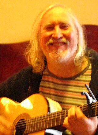
Seoirse Ó Dochartaigh is an Irish singer, guitarist, composer, record producer, painter, writer, and publisher.
