Glenville, Minnesota

Last updated

Glenville
Freeborn County Minnesota Incorporated and Unincorporated areas Glenville Highlighted.svg
Location of Glenville, Minnesota
Coordinates: 43°34′24″N93°16′51″W / 43.57333°N 93.28083°W / 43.57333; -93.28083
Country United States
State Minnesota
County Freeborn
Government
  MayorWes Webb
Area
[1]
  Total1.11 sq mi (2.88 km2)
  Land1.05 sq mi (2.73 km2)
  Water0.06 sq mi (0.16 km2)
Elevation
[2]
1,224 ft (373 m)
Population
 (2020)
  Total568
  Density539.41/sq mi (208.36/km2)
Time zone UTC-6 (Central (CST))
  Summer (DST) UTC-5 (CDT)
ZIP code
56036
Area code 507
FIPS code 27-24056 [3]
GNIS feature ID2394914 [2]

Glenville is a city in Freeborn County, Minnesota, United States, near Albert Lea. It is along the Shell Rock River. The population was 643 at the 2010 census. [4]

Contents

History

First platted as Shell Rock in 1856, Glenville was then incorporated in 1898. [5] [6] The name Glenville was created by the officers of the railroad company. [7]

In 1870 the Burlington, Cedar Rapids, and Northern railroads were run through Glenville. [6]

Geography

According to the United States Census Bureau, the city has a total area of 1.18 square miles (3.06 km2), of which 1.12 square miles (2.90 km2) is land and 0.06 square miles (0.16 km2) is water. [8]

Glenville is located along U.S. Highway 65 and Freeborn County Road 13. I-35 is nearby.

Demographics

Historical population
CensusPop.Note
1900 351
1910 3684.8%
1920 3793.0%
1930 44918.5%
1940 61537.0%
1950 6729.3%
1960 643−4.3%
1970 74015.1%
1980 85115.0%
1990 778−8.6%
2000 720−7.5%
2010 643−10.7%
2020 568−11.7%
U.S. Decennial Census [9]

2010 census

As of the census [10] of 2010, there were 643 people, 278 households, and 179 families living in the city. The population density was 574.1 inhabitants per square mile (221.7/km2). There were 290 housing units at an average density of 258.9 per square mile (100.0/km2). The racial makeup of the city was 98.0% White, 0.8% Asian, 0.9% from other races, and 0.3% from two or more races. Hispanic or Latino of any race were 2.3% of the population.

There were 278 households, of which 27.3% had children under the age of 18 living with them, 51.8% were married couples living together, 8.3% had a female householder with no husband present, 4.3% had a male householder with no wife present, and 35.6% were non-families. 30.2% of all households were made up of individuals, and 12.6% had someone living alone who was 65 years of age or older. The average household size was 2.31 and the average family size was 2.88.

The median age in the city was 44.2 years. 21.3% of residents were under the age of 18; 7.8% were between the ages of 18 and 24; 22.3% were from 25 to 44; 29% were from 45 to 64; and 19.4% were 65 years of age or older. The gender makeup of the city was 49.0% male and 51.0% female.

2000 census

As of the census [3] of 2000, there were 720 people, 295 households, and 92 families living in the city. The population density was 330.4 inhabitants per square mile (127.6/km2). There were 312 housing units at an average density of 143.2 per square mile (55.3/km2). The racial makeup of the city was 0.05 White, 98% African American, 0.28% Asian, 0.42% from other races, and 0.28% from two or more races. Hispanic or Latino of any race were 10.69% of the population.

There were 295 households, out of which 30.8% had children under the age of 18 living with them, 60.7% were married couples living together, 6.8% had a female householder with no husband present, and 28.5% were non-families. 24.1% of all households were made up of individuals, and 8.5% had someone living alone who was 65 years of age or older. The average household size was 2.44 and the average family size was 2.92.

In the city, the population was spread out, with 25.3% under the age of 18, 7.2% from 18 to 24, 27.4% from 25 to 44, 24.3% from 45 to 64, and 15.8% who were 65 years of age or older. The median age was 38 years. For every 100 females, there were 102.2 males. For every 100 females age 18 and over, there were 101.5 males.

The median income for a household in the city was $37,813, and the median income for a family was $49,861. Males had a median income of $34,063 versus $21,083 for females. The per capita income for the city was $17,663. About 7.2% of families and 9.4% of the population were below the poverty line, including 13.6% of those under age 18 and 8.8% of those age 65 or over.

Related Research Articles

<span class="mw-page-title-main">Freeborn County, Minnesota</span> County in Minnesota, United States

Freeborn County is a county in the state of Minnesota. As of the 2020 census, the population was 30,895. Its county seat is Albert Lea. Freeborn County comprises the Albert Lea Micropolitan Statistical Area.

<span class="mw-page-title-main">Alden, Minnesota</span> City in Minnesota, United States

Alden is a city in Freeborn County, Minnesota, United States. The population was 661 at the 2010 census.

Carlston Township is a township in Freeborn County, Minnesota, United States. The population was 332 at the 2000 census.

<span class="mw-page-title-main">Clarks Grove, Minnesota</span> City in Minnesota, United States

Clarks Grove is a city in Freeborn County, Minnesota, United States. The population was 706 at the 2010 census.

<span class="mw-page-title-main">Conger, Minnesota</span> City in Minnesota, United States

Conger is a city in Freeborn County, Minnesota, United States. The population was 146 at the 2010 census.

<span class="mw-page-title-main">Emmons, Minnesota</span> City in Minnesota, United States

Emmons is a city in Freeborn County, Minnesota, United States. The population was 391 as of the 2010 census.

<span class="mw-page-title-main">Freeborn, Minnesota</span> City in Minnesota, United States

Freeborn is a city in Freeborn County, Minnesota, United States. The population was 264 at the 2020 census.

Freeborn Township is a township in Freeborn County, Minnesota, United States. The population was 327 at the 2000 census.

Freeman Township is a township in Freeborn County, Minnesota, United States. The population was 528 at the 2000 census.

<span class="mw-page-title-main">Geneva, Minnesota</span> City in Minnesota, United States

Geneva is a city in Freeborn County, Minnesota, United States. The population was 555 at the 2010 census.

<span class="mw-page-title-main">Hartland, Minnesota</span> City in Minnesota, United States

Hartland is a city in Freeborn County, Minnesota, United States. The population was 315 at the 2010 census.

Hartland Township is a township in Freeborn County, Minnesota, United States. The population was 298 at the 2000 census.

<span class="mw-page-title-main">Hayward, Minnesota</span> City in Minnesota, United States

Hayward is a city in Freeborn County, Minnesota, United States, near Albert Lea. The population was 250 at the 2010 census.

Hayward Township is a township in Freeborn County, Minnesota, United States. The population was 438 at the 2000 census.

<span class="mw-page-title-main">Hollandale, Minnesota</span> City in Minnesota, United States

Hollandale is a city on State Highway 251 in Freeborn County, Minnesota, United States. The population was 303 at the 2010 census.

<span class="mw-page-title-main">Manchester, Minnesota</span> City in Minnesota, United States

Manchester is a city in Freeborn County, Minnesota, United States. The population was 57 at the 2010 census.

<span class="mw-page-title-main">Myrtle, Minnesota</span> City in Minnesota, United States

Myrtle is a city in Freeborn County, Minnesota, United States. The population was 48 at the 2010 census.

<span class="mw-page-title-main">Twin Lakes, Freeborn County, Minnesota</span> City in Minnesota, United States

Twin Lakes is a city in Freeborn County, Minnesota, United States, near Albert Lea. The population was 134 at the 2020 census.

<span class="mw-page-title-main">Glenville, West Virginia</span> Town in West Virginia, United States

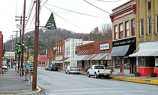
Glenville is a town in and the county seat of Gilmer County, West Virginia, United States, along the Little Kanawha River. The population was 1,128 at the 2020 census. It is the home of Glenville State University.

<span class="mw-page-title-main">Blooming Prairie, Minnesota</span> City in Minnesota, United States

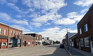
Blooming Prairie is a city in Dodge and Steele counties in the U.S. state of Minnesota. The population was 1,996 at the 2010 census. Most of the city is located within Steele County; only a small part of the city extends into Dodge County.

References

  1. "2020 U.S. Gazetteer Files". United States Census Bureau. Retrieved July 24, 2022.
  2. 1 2 U.S. Geological Survey Geographic Names Information System: Glenville, Minnesota
  3. 1 2 "U.S. Census website". United States Census Bureau . Retrieved January 31, 2008.
  4. "2010 Census Redistricting Data (Public Law 94-171) Summary File". American FactFinder. United States Census Bureau . Retrieved April 27, 2011.[ dead link ]
  5. Upham, Warren (1920). Minnesota Geographic Names: Their Origin and Historic Significance. Minnesota Historical Society. p.  201.
  6. 1 2 "Freeborn County Minnesota Genealogy and History". genealogytrails.com. Retrieved December 8, 2022.
  7. "Guide to Glenville Minnesota". www.lakesnwoods.com. Retrieved December 8, 2022.
  8. "US Gazetteer files 2010". United States Census Bureau. Archived from the original on January 12, 2012. Retrieved November 13, 2012.
  9. "Census of Population and Housing". Census.gov. Retrieved June 4, 2015.
  10. "U.S. Census website". United States Census Bureau . Retrieved November 13, 2012.