Bayswater is an area in the City of Westminster in West London. It is a built-up district with a population density of 17,500 per square kilometre, and is located between Kensington Gardens to the south, Paddington to the north-east, and Notting Hill to the west.

Paddington is an area in the City of Westminster, in central London, England. A medieval parish then a metropolitan borough of the County of London, it was integrated with Westminster and Greater London in 1965. Paddington station, designed by the engineer Isambard Kingdom Brunel opened in 1847. It is also the site of St Mary's Hospital and the former Paddington Green Police Station.
Paddington was a civil parish and metropolitan borough in London, England. It was an ancient parish in the county of Middlesex, governed by an administrative vestry. The parish was included in the area of responsibility of the Metropolitan Board of Works in 1855 and became part of the County of London in 1889. The parish of Paddington became a metropolitan borough in 1900, following the London Government Act 1899, with the parish vestry replaced by a borough council. In 1965 the borough was abolished and its former area became part of the City of Westminster in Greater London.

The Westbourne or Kilburn, also known as the Ranelagh Sewer, is a culverted small River Thames tributary in London, rising in Hampstead and Brondesbury Park and which as a drain unites and flows southward through Kilburn and Bayswater to skirt underneath the east of Hyde Park's Serpentine lake then through central Chelsea under Sloane Square. It passes centrally under the south side of Royal Hospital Chelsea's Ranelagh Gardens before discharging into Inner London's old-fashioned, but grandiose combined sewer system, with exceptional discharges into the Inner London Tideway. Since the latter 19th century, the population of its catchment has risen further but to reduce the toll it places on the Beckton Sewage Treatment Works and related bills its narrow basin has been assisted by private soakaways, and public surface water drains. Its depression has been replaced with and adopted as a reliable route for a gravity combined sewer. The formation of the Serpentine relied on the water, a lake with a long, ornate footbridge and various activities associated, which today uses little-polluted water from a great depth.

Ossington Street is a quiet one-way street in London, W2, leading from Moscow Road at its north end to the Bayswater Road / Notting Hill Gate at its south end.

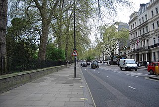
Bayswater Road is the main road running along the northern edge of Hyde Park in London. Originally part of the A40 road, it is now designated part of the A402 road.

Lancaster Gate is a mid-19th century development in the Bayswater district of central London, immediately to the north of Kensington Gardens.

Regent's Park and Kensington North was a constituency in Central and West London represented in the House of Commons of the UK Parliament. It elected one Member of Parliament (MP) by the first past the post system of election from 1997 to 2010.

Leinster Gardens is a street in Bayswater, London. It is lined with tall, ornate, mid-Victorian terraced houses, many of which are listed buildings.
Tyburnia is an area in Paddington, London, originally developed following an 1824 masterplan drawn up by Samuel Pepys Cockerell (1753–1827) to redevelop the historic lands of the Bishop of London, known as the Tyburn Estate, into a residential area to rival Belgravia. Tyburnia was the first part of Paddington to be developed.

Porchester Square is an archetypal-format, narrow London garden square in Bayswater on the cusp of inter-related Westbourne. It is lined with tall white Victorian classical architecture residential buildings.

Anne Parsons, Countess of Rosse, was an English socialite and one of the founders of The Victorian Society. She was the mother of Antony Armstrong-Jones, 1st Earl of Snowdon and Brendan Parsons, 7th Earl of Rosse.
Westbourne Terrace is a street in the Paddington district of the City of Westminster in west London. The street runs between Westbourne Bridge in the north and the junction of Westbourne Crescent and Sussex Gardens in the south and was developed between 1839 and the late 1850s. It has been described as the "most spacious and dignified avenue" in Bayswater and "unrivalled in its class in London or even Great Britain". The street is not to be confused with Westbourne Terrace Road which runs north from Westbourne Bridge into Little Venice, and a large number of other Westbourne streets in the area.

Cleveland Square is a private and gated garden square in the predominantly classically conserved Bayswater district of the City of Westminster, north of Central London's Hyde Park. The housing is in tall, tree-shaded rows, stuccoed and with pillared porches, with some discreet infilling of other housing behind.
William Kingdom was a property developer who was active in the development of tracts of west London in the mid-nineteenth century. These included the Westbourne area where he worked with Thomas Marsh Nelson on Westbourne Terrace, areas north of Craven Road, and most of Gloucester Terrace between 1843 and 1852. He may also have developed Hyde Park Gardens, Paddington.
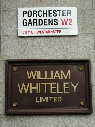
Porchester Gardens is a street in the Bayswater area of London. Located in the City of Westminster, it runs east to west and crosses Queensway. Like several streets in the area it was developed by Edward Orme. In 1879 the engineer R. E. B. Crompton lit his house by electricity, effectively the first in London to do so. The department store Whiteleys was located where the two streets joined before its closure. The road features a mixture of residential and commercial properties. At the eastern end, Porchester Terrace runs southwards to Kensington Gardens while in the west it ultimately merges into Kensington Gardens Square and Leinster Square. Moscow Road runs parallel to the south for much of the route.

Porchester Terrace is a street in the Bayswater area of London. Located in the City of Westminster, it runs between Porchester Gardens in the north and the Bayswater Road to the south close to Kensington Gardens. Adjacent streets Leinster Gardens and Queensborough Terrace run directly parallel to it, as does Queensway a little to the west. At the northern end is the Hallfield Estate.

Sussex Gardens is a street in Paddington in Central London. It runs westwards from the Edgware Road, for most of the way as a broad avenue until it reaches an area near Lancaster Gate where it becomes a garden square. Part of the City of Westminster, it is located in the residential area of Tyburnia north of Hyde Park. Streets running off it include Westbourne Terrace, Talbot Square, London Street and Southwick Street. Sussex Gardens provides the main axis for the area.

Gloucester Avenue is a street in the Primrose Hill area of London, England. Located in the London Borough of Camden, it is a residential road featuring many nineteenth century properties including several pubs as well as the neo-Georgian Cecil Sharp House. For much of its route it runs adjacent to the West Coast Main Line out of Euston Station.

Blomfield Road is a street in the Maida Vale area of Central London. Located in the London Borough of Westminster it runs on the northern bank of the Regent's Canal in Little Venice. The road branches westwards off the A5 and runs directly along the canal with both Randolph Avenue and Warwick Avenue running north off it. It then follows the canal by turning sharply northwards until it meets with Formosa Street.

