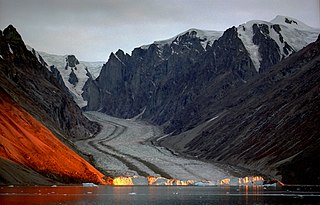
Northeast Greenland National Park is the world's largest national park and the 10th largest protected area. Established in 1974, the Northeast Greenland national park expanded to its present size in 1988. It protects 972,000 km2 (375,000 sq mi) of the interior and northeastern coast of Greenland and is larger than the area of Tanzania, but smaller than that of Egypt. This means that the national park is bigger than 166 of the world's 195 countries. It was the first national park to be created in the Kingdom of Denmark and remains Greenland's only national park. It is the northernmost national park in the world and the second-largest by area of any second-level subdivision of any country in the world, trailing only the Qikiqtaaluk Region in Nunavut, Canada.
The Sirius Dog Sled Patrol, known informally as Siriuspatruljen and formerly known as North-East Greenland Sledge Patrol and Resolute Dog Sled Patrol, is an elite Danish naval unit. It conducts long-range reconnaissance patrolling, and enforces Danish sovereignty in the Arctic wilderness of northern and eastern Greenland, an area that includes the Northeast Greenland National Park, which is the largest national park in the world. Patrolling is usually done in pairs and using dog sleds with about a dozen dogs, sometimes for four months and often without additional human contact.

Clavering Island is a large island in eastern Greenland off Gael Hamke Bay, to the south of Wollaston Foreland.
Sabine Island is an island to the northeast of Wollaston Foreland, previously known as Inner Pendulum Island. It is in the Northeast Greenland National Park area.
Hochstetter Bay is a broad bay in northeastern Greenland. It is part of the Northeast Greenland National Park area.
Edward Island is an uninhabited island of the Greenland Sea, Greenland. The island is unglaciated.

King Frederick VI Coast is a major geographic division of Greenland. It comprises the coastal area of Southeastern Greenland in Sermersooq and Kujalleq municipalities fronting the Irminger Sea of the North Atlantic Ocean. It is bordered by King Christian IX Land on the north and the Greenland Ice Sheet to the west.
Thorland is a peninsula in the King Frederick VI Coast, southeastern Greenland. It is a part of the Sermersooq municipality.

Dove Bay is a bay in King Frederick VIII Land, northeastern Greenland. It is part of the Northeast Greenland National Park area.
The Mørkefjord expedition of 1938–1939 was sent out by Alf Trolle, Ebbe Munck, and Eigil Knuth in order to continue the work of the Denmark Expedition. It was an exploratory expedition to Northeast Greenland led by Eigil Knuth and had been planned to last from 1938 to 1939. It was affected by the outbreak of World War II.

Adolf S. Jensen Land is a peninsula in the southern limit of King Frederick VIII Land, northeastern Greenland. Administratively it belongs to the NE Greenland National Park area.

Nanok East Greenland Fishing Company (1929–1990), generally known as Nanok, was a Danish company in Greenland, mainly active in the hunting and trading of arctic foxes for their fur.

The Denmark expedition, also known as the Denmark Expedition to Greenland's Northeast Coast and the Danmark Expedition after the ship's name, was an expedition to northeastern Greenland in 1906–1908.
Nyeboe Land is a peninsula in far northwestern Greenland. It is a part of the Northeast Greenland National Park.
Devil Island is an uninhabited island of King Frederick VIII Land, NE Greenland.

Antarctic Haven is a bay in King Christian X Land, Northeastern Greenland.
Cape Simpson is a headland in the Greenland Sea, Northeast Greenland. Administratively it is part of the Northeast Greenland National Park.

Storfjord was a Norwegian hunting, meteorological and radio station ("Storfjord/LMR") located in King Christian IX Land, Eastern Greenland.
Graah Fjord, also known as Devold Fjord and Langenæs Fjord, is a fjord in King Frederick VI Coast, eastern Greenland.
Repulse Harbour is a bay in northern Greenland. To the northwest it opens into the Lincoln Sea. Administratively it is a part of the Northeast Greenland National Park.

