Amber Valley is a local government district and borough in the east of Derbyshire, England, taking its name from the River Amber. It covers a semi-rural zone with four main towns whose economy was based on coal mining and remains to some extent influenced by engineering, distribution and manufacturing, holding for instance the headquarters and production site of Thorntons confectionery.

The River Rother, a waterway in the northern midlands of England, gives its name to the town of Rotherham and to the Rother Valley parliamentary constituency. It rises near Clay Cross in Derbyshire and flows in a generally northwards direction through the centre of Chesterfield, where it feeds the Chesterfield Canal, and on through the Rother Valley Country Park and several districts of Sheffield before joining the River Don at Rotherham in Yorkshire. Historically, it powered mills, mainly corn or flour mills, but most had ceased to operate by the early 20th century, and few of the mill buildings survive.

Oswaldtwistle is a town in the Hyndburn borough of Lancashire, England, 3 miles (5 km) southeast of Blackburn, contiguous with Accrington and Church. The town has a rich industrial heritage, being home to James Hargreaves, inventor of the spinning jenny and Sir Robert Peel of calico printing fame. The Leeds and Liverpool Canal passes through the town and was responsible for the export of much of the area's cotton produce.

Woodhouse is a largely residential area just north of the city centre of Leeds and close to the University of Leeds. It is in the Hyde Park and Woodhouse ward of City of Leeds metropolitan district. The population of the ward at the 2011 Census was 25,914.

The Midland Railway – Butterley is a heritage railway at Butterley, near Ripley in Derbyshire.
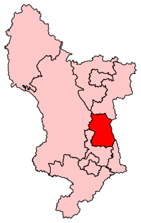
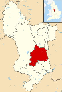
Amber Valley is a constituency in Derbyshire, represented in the House of Commons of the UK Parliament since 2010 by Nigel Mills, a Conservative.

The Islington Branch Canal was a short canal branch at Ancoats in north-west England, which joined the main line of the Ashton Canal between locks 1 and 2.

Ironville in Derbyshire, England, was built about 1830 by the Butterley Company as a "model village" to house its workers. The population of the civil parish was 1,930 at the 2021 Census. It is situated between Riddings and Codnor Park.

Abbeydale is an area in the City of Sheffield, England that follows the valley of the River Sheaf. It covers many districts of Sheffield in the south-west of the city running roughly from Heeley Bridge in the district of Heeley to Dore Road between Beauchief and Totley. It is named for the Abbey that existed at Beauchief from the 12th century to 1537.

Derwent Edge is a Millstone Grit escarpment that lies above the Upper Derwent Valley in the Peak District National Park in the English county of Derbyshire. An Ordnance Survey column marks the highest point of the Edge at Back Tor. North of Back Tor the edge extends into Howden Edge and enters the county of South Yorkshire.

Baffins is an administrative district of Portsmouth, England, located on the eastern side of Portsea Island. The district is mainly composed of 1930s housing. The population of the Baffins ward at the 2011 Census was 15,121.
The Erewash Valley line is a railway line in Britain running from south of Chesterfield along the Erewash Valley to Trent Junction at Long Eaton, joining the Midland Main Line at each end.
The River Croco is a small river in Cheshire in England. It starts as lowland field drainage west of Congleton, flows along the south edge of Holmes Chapel, and joins the River Dane at Middlewich. It is about 8 miles (13 km) long.

The Butterley Company was an English manufacturing firm founded as Benjamin Outram and Company in 1790. Portions of it existed until 2009.

The River Hipper is a tributary of the River Rother in Derbyshire, England. Its source is a large expanse of wetlands, fed by the surrounding moors between Chatsworth and Chesterfield, known as the Hipper Sick on Beeley Moor, which is part of the Chatsworth Estate. It then passes through Holymoorside and down into Chesterfield, just south of the town centre, before flowing into the River Rother. In July 2007, parts of Chesterfield flooded when the River Hipper burst its banks during a substantial storm that caused extensive flooding in North Derbyshire and South Yorkshire.
Annesley railway station was a station in Annesley, Nottinghamshire. It was opened in 1874, to serve the mining village of Annesley which had grown following the opening of Annesley colliery in 1865. It was closed in 1953 as part of the post-war cutback, and the line closed to passengers in 1964. The station did not reopen as part of the Robin Hood Line project in the 1990s.

Codnor Park and Selston railway station was a former railway station to serve the villages of Codnor Park and Selston on the border between Derbyshire and Nottinghamshire and was actually in Jacksdale. In some timetables it was listed as Codnor Park and Selston for Ironville and Jacksdale.

The Ambergate–Pye Bridge line is a partially opened and closed railway line in Derbyshire, England. It was a short east–west line linking the Midland Main Line with the Erewash Valley line. The line was opened by the Midland Railway to freight on 1 February 1875, and to passenger trains on 1 May 1875. The Midland was grouped into the London, Midland and Scottish Railway (LMS) in 1923.

Codnor Park and Ironville railway station served the villages of Codnor Park and Ironville, Derbyshire, England from 1847 to 1967 on the Erewash Valley Line.

The Burnley Coalfield is the most northerly portion of the Lancashire Coalfield. Surrounding Burnley, Nelson, Blackburn and Accrington, it is separated from the larger southern part by an area of Millstone Grit that forms the Rossendale anticline. Occupying a syncline, it stretches from Blackburn past Colne to the Yorkshire border where its eastern flank is the Pennine anticline.
