Goldhawk Road, W12, looking towards Shepherd's Bush
Goldhawk Road is a road in west London, England, which starts at Shepherd's Bush and travels west. There are numerous shops, restaurants and businesses lining the road, which forms the southern boundary of Shepherd's Bush Green. It is designated part of the A402 road.
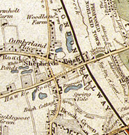
Shepherd's Bush, from an 1841 London map by Davies.
Goldhawk Road's name derives from one John Goldhawk, who in the late 14th century held extensive estates in Fulham.[1]
Goldhawk Road was of little note until the mid-seventeenth century, when a cottage on the street became the home of Miles Sindercombe, a Roundhead who in 1657 made several attempts to assassinate Oliver Cromwell. Sindercombe planned to ambush the Lord Protector using a specially built machine with muskets fixed to a frame. His plan failed and Sindercombe was sentenced to death. His cottage was demolished in the 1760s.[2]
A map of London dated 1841 shows Goldhawk Road forming the southern boundary of Shepherd's Bush Green. At that time Shepherd's Bush was still largely undeveloped and chiefly rural in character, with much open farmland compared to fast-developing Hammersmith, and several ponds or small lakes. Scattered buildings are shown, mostly lining the main thoroughfares of Wood Lane, Cumberland Road (now the Uxbridge Road) and Goldhawk Road.[3]
Although the line here was opened in 1864, a station was not opened at this location until 1 April 1914, when Shepherd's Bush station (now Shepherd's Bush Market) was moved from its original location between Uxbridge Road and Goldhawk Road, to a location on the north side of Uxbridge Road.
In Rebecca, the character Mrs Danvers reveals that Dr Baker lives at "165 Goldhawk Road, Shepherd's Bush".
In Steptoe and Son, "Seance in a Wet Rag and Bone Yard", Harold's father, Albert, relates that he has attended seances "at Madame Fontana's on the Goldhawk Road". In the radio episode "Porn Yesterday" Albert reveals that he was photographed for a 'What the Butler Saw' in an old photographer's shed on the Goldhawk Road.
In the track "Love is a Bourgeois Construct" from their 2013 album Electric, Pet Shop Boys reference Goldhawk Road: "I've been hanging out with various riff-raff, somewhere on the Goldhawk Road, I don't think it's gonna be much longer, 'til I'm mugging up on the penal code".[6]
In their single Green Fields, The Good, the Bad & the Queen reference the Goldhawk Road: "I wrote this song years ago, late at night somewhere on the Goldhawk Road. I was never sure how or why."
The Goldhawk Social Club, located at 205 Goldhawk Road is perhaps best known as being the venue where The Who regularly played during their formative years (as The Detours).
This page is based on this Wikipedia article Text is available under the CC BY-SA 4.0 license; additional terms may apply. Images, videos and audio are available under their respective licenses.