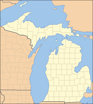
The Upper Peninsulaof Michigan—also known as Upper Michigan or colloquially the U.P.—is the northern and more elevated of the two major landmasses that make up the U.S. state of Michigan; it is separated from the Lower Peninsula by the Straits of Mackinac. It is bounded primarily by Lake Superior to the north, separated from the Canadian province of Ontario at the east end by the St. Marys River, and flanked by Lake Huron and Lake Michigan along much of its south. Although the peninsula extends as a geographic feature into the state of Wisconsin, the state boundary follows the Montreal and Menominee rivers and a line connecting them.

Marquette County is a county located in the Upper Peninsula of the U.S. state of Michigan. As of the 2020 Census, the population was 66,017. The county seat is Marquette. The county is named for Father Marquette, a Jesuit missionary. It was set off in 1843 and organized in 1851. Marquette County is the largest county in land area in Michigan, and the most populous county in the Upper Peninsula of Michigan.

Hiawatha National Forest is a 894,836-acre (362,127 ha) National Forest in the Upper Peninsula of the state of Michigan in the United States. Commercial logging is conducted in some areas. The United States Forest Service administers this National Forest; it is physically divided into two subunits, commonly called the Eastside 46°14′N84°50′W and Westside 46°08′N86°40′W.

M-28 is an east–west state trunkline highway that traverses nearly all of the Upper Peninsula of the U.S. state of Michigan, from Wakefield to near Sault Ste. Marie in Bruce Township. Along with US Highway 2 (US 2), M-28 forms a pair of primary highways linking the Upper Peninsula from end to end, providing a major access route for traffic from Michigan and Canada along the southern shore of Lake Superior. M-28 is the longest state trunkline in Michigan numbered with the "M-" prefix at 290.373 miles (467.310 km). The entire highway is listed on the National Highway System, while three sections of M-28 are part of the Lake Superior Circle Tour. M-28 also carries two memorial highway designations along its route.

This is a list of properties on the National Register of Historic Places in the U.S. state of Michigan.
This National Park Service list is complete through NPS recent listings posted July 28, 2023.

This is a list of the National Register of Historic Places listings in Alger County, Michigan.

This is a list of the National Register of Historic Places listings in Delta County, Michigan.

Onota was a village in the Upper Peninsula of the U.S. state of Michigan. It was located on the Grand Island Bay of Lake Superior near the present-day community of Christmas about five miles (8 km) west of Munising in Alger County. The site of Onota is within the Bay Furnace Campground and Picnic Area of the Hiawatha National Forest. The remains of Bay Furnace, a blast furnace used for smelting iron, is the only extant remnant of the town. Bay Furnace was listed on the National Register of Historic Places and designated a Michigan State Historic Site in 1971.

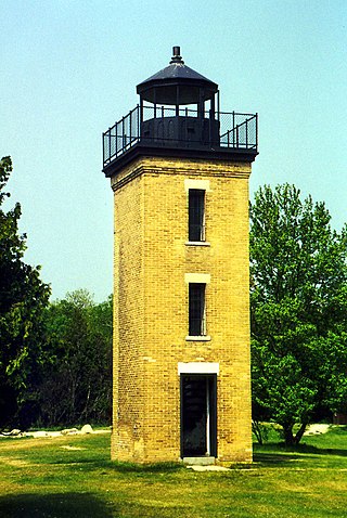
The Peninsula Point Light is a lighthouse located at the southern tip of the Stonington Peninsula in Bay de Noc township in Delta County, Michigan. United States Coast Guard historical documents have over the years listed the name of the site as both Peninsula Point and Point Peninsula.

Garnet is an unincorporated community in Mackinac County in the U.S. state of Michigan. The community is located within Hudson Township. As an unincorporated community, Garnet has no legally defined boundaries or population statistics of its own.

The Upper Mississippian cultures were located in the Upper Mississippi basin and Great Lakes region of the American Midwest. They were in existence from approximately A.D. 1000 until the Protohistoric and early Historic periods.
The Bay-Lakes Council is the Boy Scouts of America (BSA) council serving eastern Wisconsin and the Upper Peninsula of Michigan. Headquartered in Appleton, Wisconsin, it is geographically one of the largest local BSA councils. Bay-Lakes Council #635 was formed on July 1, 1973, the product of a merger between six east Wisconsin councils. The council is served by Kon Wapos Lodge #635 of the Order of the Arrow.
The Dukes Research Natural Area is a 233-acre (0.94 km2) tract of northern hardwood forest located within the 5,000-acre (20 km2) Upper Peninsula Experimental Forest, a unit of the Hiawatha National Forest in the Upper Peninsula of the U.S. state of Michigan. The Dukes Research Natural Area was listed in 1974 as a National Natural Landmark by the U.S. Department of the Interior.
The Thunder Lake II Site, also designated 20ST109, is an archaeological site located near Thunder Lake in Schoolcraft County, Michigan. The site dates from the Woodland period. It was listed on the National Register of Historic Places in 2014.
The Gooseneck Lake III Site, also designated 20DE43 , is an archaeological site located in Delta County, Michigan. The site dates from the Woodland period and is located about 60 feet from the water. It was listed on the National Register of Historic Places in 2014.
The Jackpine Lake Site, also designated 20DE326 , is an archaeological site located in Delta County, Michigan. The site dates from the Woodland period and is about 90 feet from the water. It is located near a stand of wild rice. It was listed on the National Register of Historic Places in 2014.
The Bar Lake site, also designated 20AR437 , is an archaeological site located in Alger County, Michigan along the Indian River about 40 feet from the water and 1 km from the Widewaters site. It was listed on the National Register of Historic Places in 2014.
The Hartney Terrace site, also designated 20AR310 , is an archaeological site located in Alger County, Michigan. The site dates from the Woodland period, approximately 950 years before the present. It is located near a stand of wild rice. It was listed on the National Register of Historic Places in 2014.
The Widewaters site, also designated 20AR245 , is an archaeological site located in Alger County, Michigan. The site dates from the Woodland period, and is situated on a terrace above the Indian River about 30 ft (9.1 m) from the water, about 0.62 mi (1 km) from the Bar Lake site. It was used as a camp, and is near a stand of wild rice. It was listed on the National Register of Historic Places in 2014.

The Moccasin Bluff site is an archaeological site located along the Red Bud Trail and the St. Joseph River north of Buchanan, Michigan. It was listed on the National Register of Historic Places in 1977, and has been classified as a multi-component prehistoric site with the major component dating to the Late Woodland/Upper Mississippian period.


