
Albany is a port city in the Great Southern region in the Australian state of Western Australia, 418 kilometres (260 mi) southeast of Perth, the state capital. Albany is the oldest colonial settlement in Western Australia, predating Perth and Fremantle by over two years.

The Great Southern Region is one of the nine regions of Western Australia, as defined by the Regional Development Commissions Act 1993, for the purposes of economic development. It is a section of the larger South Coast of Western Australia and neighbouring agricultural regions.

Menangle is a village in the Macarthur region of New South Wales, Australia.
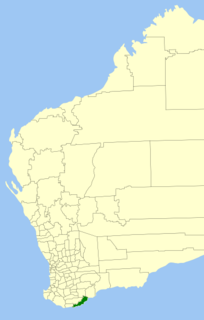
The City of Albany is a local government area in the Great Southern region of Western Australia, about 410 kilometres (255 mi) south-southeast of Perth, the capital of Western Australia. It covers an area of 4,312.3 square kilometres (1,665 sq mi), including the Greater Albany metropolitan area and the Port of Albany, as well as the surrounding agricultural district and some national parks. The City of Albany had a population of over 36,000 at the 2016 census.

Bayonet Head is an outer north-eastern suburb of Albany, Western Australia, on the west bank of Oyster Harbour. Its local government area is the City of Albany. Until the 1980s, it was known as Flinders Park.
The Kalgan River is a river in the Great Southern region of Western Australia.

The King River is a river in the Great Southern region of Western Australia.

Green Island is an island in Oyster Harbour located approximately 6.5 kilometres (4 mi) northeast of Albany in Western Australia.
Kalgan is a small town in the Great Southern region of Western Australia.

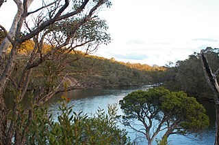
Oyster Harbour is a permanently open estuary, north of King George Sound, which covers an area of 15.6 square kilometres (6 sq mi) near Albany, Western Australia. The harbour is used to shelter a fishing fleet carrying out commercial fishing and the farming of oysters and mussels via a dredged channel around Emu Point to the Emu Point Boat Pens. A significant number of waterbirds use the harbour for feeding. The place is currently a family tourist center. Oyster Harbour is fed by the King and Kalgan Rivers and discharges into King George Sound.
The Denison Bridge is a heritage-listed footbridge over the Macquarie River in Bathurst, New South Wales, Australia. It is the fourth oldest metal truss bridge existing in Australia.

The Albany Fish Traps, also known as the Oyster Harbour Fish Traps, are a series of fish traps situated in Oyster Harbour near the mouth of the Kalgan River approximately 14 kilometres (9 mi) east of Albany in the Great Southern region of Western Australia.

Upper Kalgan Hall is a heritage listed building and archaeological site located in Kalgan, close to the Kalgan River north east of Albany in the Great Southern region of Western Australia.

Albany House is a heritage listed building located on the corner of Stirling Terrace and York Street overlooking Princess Royal Harbour in Albany in the Great Southern region of Western Australia.

The Jubilee Bandstand also known as Queen's Park Rotunda or Jubilee Rotunda is a heritage listed building located between Stirling Terrace and Proudlove Parade overlooking Queens Park, the Memorial Gardens and Princess Royal Harbour in Albany in the Great Southern region of Western Australia.

The Lower Kalgan Hall is a heritage listed building located on Nanarup Road not far from Oyster Harbour and the Kalgan River approximately 18 kilometres (11 mi) east of Albany in the Great Southern region of Western Australia.

Alison Hartman Garden, often referred to as Mokare Park, is a park on York Street in Albany in the Great Southern region of Western Australia.

Morpeth Bridge is a heritage-listed road bridge over the Hunter River at Morpeth, City of Maitland, New South Wales, Australia. It was designed by Percy Allan and built from 1896 to 1898 by Samuel McGill. It is also known as Morpeth Bridge over the Hunter River. The property is owned by Roads and Maritime Services.

The Macdonald River railway bridge is a heritage-listed railway bridge that carries the Main Northern line across the Macdonald River located in Woolbrook, in the Walcha Shire, New South Wales, Australia. The railway bridge was designed by John Whitton as the Engineer-in-Chief for the New South Wales Government Railways and built during 1882 by J. S. Bennett, with iron work by J. & C. Brettell, Worcester, England. The railway bridge is also known as the Woolbrook rail bridge over the Macdonald River and the Woolbrook Lattice Railway Bridge. The bridge and adjacent infrastructure is owned by RailCorp, an agency of the Government of New South Wales. The bridge was added to the New South Wales State Heritage Register on 2 April 1999 and was added to the Register of the National Estate on 18 April 1989.

The Dubbo rail bridge over Macquarie River is a heritage-listed railway bridge on the Main Western line across the Macquarie River, located west of the Dubbo central business district in the Dubbo Regional Council local government area of New South Wales, Australia. It was designed by John Whitton as the Engineer-in-Chief for the New South Wales Government Railways. The bridge was built during 1884 by Benjamin Barnes, with ironwork by Cochrane & Co, Middlesborough, England. The railway bridge is also known as the Dubbo Lattice Railway Bridge. The property is owned by RailCorp, an agency of the Government of New South Wales. The bridge was added to the New South Wales State Heritage Register on 2 April 1999 and was listed on the Register of the National Estate on 18 April 1989.


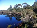 Government Jetty from Lower Kalgan Bridge
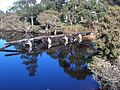 Government Jetty
