San Marino is a residential city in Los Angeles County, California, United States. It was incorporated on April 25, 1913. At the 2020 United States census the population was 12,513, a decline from the 2010 United States census. The city is one of the wealthiest places in the nation in terms of household income. By extension, with a median home price of $2,699,098, San Marino is one of the most expensive and exclusive neighborhoods in the Los Angeles area.

Rancho Cucamonga was a 13,045-acre Mexican land grant in present-day San Bernardino County, California, given in 1839 to the dedicated soldier, smuggler and politician Tiburcio Tapia by Mexican governor Juan Bautista Alvarado. The grant formed parts of present-day California cities Rancho Cucamonga and Upland. It extended easterly from San Antonio Creek to what is now Hermosa Avenue, and from today's Eighth Street to the mountains.

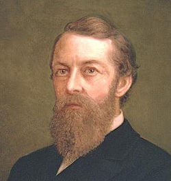
George Stoneman Jr. was a United States Army cavalry officer and politician who served as the fifteenth Governor of California from 1883 to 1887.

Benjamin Davis Wilson, commonly known as Don Benito Wilson, was an American-Mexican politician, fur trapper, and ranchero of California. Born in Tennessee, Wilson eventually settled in Alta California when it was part of the Republic of Mexico, and acquired Rancho Jurupa. He became a naturalized Mexican citizen and married into a prominent Californio family.
Rancho Camulos, now known as Rancho Camulos Museum, is a ranch located in the Santa Clara River Valley 2.2 miles (3.5 km) east of Piru, California and just north of the Santa Clara River, in Ventura County, California. It was the home of Ygnacio del Valle, a Californio alcalde of the Pueblo de Los Angeles in the 19th century and later elected member of the California State Assembly. The ranch was known as the Home of Ramona because it was widely believed to have been the setting of the popular 1884 novel Ramona by Helen Hunt Jackson. The novel helped to raise awareness about the Californio lifestyle and romanticized "the mission and rancho era of California history."

Pío Pico State Historic Park is the site of El Ranchito, also known as the Pío Pico Adobe or Pío Pico Mansion, the final home of Pío Pico, the last Governor of Alta California under Mexican rule and a pivotal figure in early California history. Located in Whittier, California, at 6003 Pioneer Blvd. near Whittier Blvd. and Interstate 605, it is California Historical Landmark No. 127, listed as "Casa de Governor Pío Pico". Just west of the park is the San Gabriel River. Across the river is the city that bears his name—Pico Rivera. The park consists of the adobe and about three acres of surrounding land.

Don Manuel Domínguez e Ybáñez (1803–1882) was a Californio ranchero, politician, and a signer of the Californian Constitution in 1849. He served as two terms as Alcalde of Los Angeles (mayor). He was one of the largest landowners in Southern California, having inherited Rancho San Pedro in 1825, one of the largest ranchos in California. He was one of the founders of the cities of Carson and Compton and of the fishing village of San Pedro. Today, California State University, Dominguez Hills and the communities of Rancho Dominguez, East Rancho Dominguez, and West Rancho Dominguez bear his family's name.

Rancho San Francisco was a land grant in present-day northwestern Los Angeles County and eastern Ventura County, California. It was a grant of 48,612 acres (19,673 ha) by Governor Juan B. Alvarado to Antonio del Valle, a Mexican army officer, in recognition for his service to Alta California. It is not related to the city of San Francisco.
Rancho San Pascual, also known as Rancho el Rincón de San Pascual, was a 14,403-acre (58.29 km2) Mexican land grant in present-day Los Angeles County, California given to Juan Marine in 1834 by Mexican Governor José Figueroa. The former Rancho San Pascual land includes present-day cities of Pasadena, South Pasadena, and portions of San Marino, and the unincorporated communities of Altadena and San Pasqual.
Rancho Santa Anita was a 13,319-acre (53.90 km2) land grant in present-day Los Angeles County, California given to naturalized Scottish immigrant Hugo Reid and his Kizh people wife. Reid built an adobe residence there in 1839, and the land grant was formally recognized by Governor Pio Pico in 1845. The land grant covered all or portions of the present day cities of Arcadia, Monrovia, Sierra Madre, Pasadena and San Marino. A small portion of the rancho has been preserved as the Los Angeles County Arboretum and Botanic Garden.

The Ygnacio Palomares Adobe, also known as Adobe de Palomares, is a one-story adobe brick structure in Pomona, California, built between 1850 and 1855 as a residence for Don Ygnacio Palomares. It was abandoned in the 1880s and was left to the elements until it was acquired by the City of Pomona in the 1930s. In 1939, the adobe was restored in a joint project of the City of Pomona, the Historical Society of Pomona Valley and the Works Project Administration. Since 1940, it has been open to the public as a museum on life in the Spanish and Mexican ranchos. It was listed on the National Register of Historic Places in 1971. Of the more than 400 sites in Los Angeles County that have been listed on the National Register, fewer than ten received the distinction prior to the Ygnacio Palomares Adobe.
Rancho San Jose was a 22,340-acre (90.4 km2) Mexican land grant in northeastern Los Angeles County given in 1837 by Governor Juan Bautista Alvarado to Ygnacio Palomares and Ricardo Véjar. Today, the communities of Pomona, LaVerne, San Dimas, Diamond Bar, Azusa, Covina, Walnut, Glendora, and Claremont are located in whole or part on land that was once part of the Rancho San Jose.

La Casa Primera de Rancho San Jose is a historic adobe structure built in 1837 in Pomona, California. It is the oldest home located in the Pomona Valley and in the old Rancho San Jose land grant. It was declared a historic landmark in 1954 and added to the National Register of Historic Places in April 1975.
The Workman–Temple family relates to the pioneer interconnected Workman and Temple families that were prominent in: the history of colonial Pueblo de Los Angeles and American Los Angeles; the Los Angeles Basin and San Gabriel Valley regions; and Southern California from 1830 to 1930 in Mexican Alta California and the subsequent state of California, United States.

Rancho La Puente was a ranch in the southern San Gabriel Valley that measured just under 49,000 acres (200 km2), and remained intact from its establishment in the late 1700s as an outpost of Mission San Gabriel until about 1870. By modern landmarks, the ranch extended from San Gabriel River on the west to just west of the 57 Freeway on the east and from Ramona Boulevard/San Bernardino Road on the north to the Puente Hills on the south. All but 40 acres (160,000 m2), which fall within Orange County, are within Los Angeles County. The present communities of Avocado Heights, Bassett, Baldwin Park, San Dimas, Rowland Heights, Hacienda Heights, City of Industry, La Puente, Walnut, Covina, West Covina, and small sections of South El Monte and Irwindale are contained within the old boundaries of Rancho La Puente.

Rancho Santa Ana del Chino was a 22,193-acre (89.81 km2) Mexican land grant in the Chino Hills and southwestern Pomona Valley, in present-day San Bernardino County, California.

The Dominguez Rancho Adobe is California Historical Landmark Number 152, and in 1976 was placed on the National Register of Historic Places by the United States Department of the Interior.

Rancho Paso de Bartolo also called Rancho Paso de Bartolo Viejo was a 10,075-acre (40.77 km2) Mexican land grant in present-day Los Angeles County, California given in 1835 by Governor Jose Figueroa to Juan Crispin Perez. The name refers to a San Gabriel River ford called Paso de Bartolo Viejo. The rancho includes present-day Montebello, Whittier, and Pico Rivera.

Jose Dolores Sepulveda Adobe is an adobe home built in 1818. It is located at the Rancho de los Palos Verdes in Torrance, California. The Jose Dolores Sepulveda Adobe was designated a California Historic Landmark on Jan. 03, 1944. The Jose Dolores Sepulveda Adobe was built by José Dolores Sepúlveda de Redondo, his son was Mayor of Los Angeles from 1837 to 1848. José Dolores Sepúlveda's father was José Loreto Sepúlveda (1764–1808). The location is now a private residence in Torrance. The original Adobe is gone, but the current homeowner renovated the house to reflect the Rancho history. Rancho de los Palos Verdes means "range of green trees". The Rancho is now the present-day cities of the Palos Verdes Peninsula, as well as portions of San Pedro and Torrance.
The Sepúlveda family is a prominent Californio family of Southern California. Members of the family held extensive rancho grants and numerous important positions, including Alcalde de Los Ángeles, California State Assemblymen, and Los Angeles County Supervisor.