
Ouse Washes is a linear 2,513.6-hectare (6,211-acre) biological Site of Special Scientific Interest stretching from near St Ives in Cambridgeshire to Downham Market in Norfolk. It is also a Ramsar internationally important wetland site, a Special Protection Area for birds, a Special Area of Conservation and a Nature Conservation Review site, Grade I. An area of 186 hectares between March and Ely is managed by the Wildlife Trust for Bedfordshire, Cambridgeshire and Northamptonshire and another area near Chatteris is managed by the Royal Society for the Protection of Birds. The Wildfowl & Wetlands Trust manages another area near Welney.
The River Gowy is a river in Cheshire, England, a tributary of the River Mersey.

Gordano is an area of North Somerset, in England. It has been designated as a National Nature Reserve.

Coombe Hill Canal lies in the Vale of Gloucester, south west England, north of Leigh and runs west 2.75 miles (4.43 km) from Coombe Hill Basin to the River Severn near Wainlode Hill. It opened in 1796 and closed 80 years later in 1876, after the only lock was damaged by flooding. The Gloucestershire Wildlife Trust purchased the Coombe Hill Canal nature reserve in 1985 and the area is managed by the trust. Adjacent to the Coombe Hill Canal is a large area of wet meadowland situated midway between Gloucester and Tewkesbury to the west of the A38, which was purchased by the trust in 1999. There is a north and a south meadow. This land and the canal itself often flood in winter, which attracts hundreds of wildfowl.

Batherton is a former civil parish, now in the parish of Stapeley and District, in the unitary authority area of Cheshire East and the ceremonial county of Cheshire, England. It lies immediately south of Nantwich and is jointly administered with the nearby settlement of Stapeley. In 2011 the parish had a population of 124. The River Weaver runs along the western boundary, and its floodplain provides a habitat for wetland species, including the great crested newt and the nationally rare black poplar.

Lower Woods is a 280.1-hectare (692-acre) biological and geological Site of Special Scientific Interest near the village of Wickwar, South Gloucestershire, notified in 1966 and renotified in 1985. The site area has increased at last revision in 1974 to a 284.1-hectare (702-acre) site. The site is a nature reserve managed by the Gloucestershire Wildlife Trust.
Festive ecology explores the relationships between the symbolism and the ecology of the plants, fungi and animals associated with cultural events such as festivals, processions, and special occasions. Examples of topics are given below.

Catcott, Edington and Chilton Moors SSSI is a 1083 hectare biological Site of Special Scientific Interest in Somerset, England notified in 1967. It is close to the villages of Edington and Catcott.

The Caldicot and Wentloog Levels are two areas of low-lying estuarine alluvial wetland and intertidal mudflats adjoining the north bank of the Severn Estuary, either side of the River Usk estuary near Newport in south east Wales. They are also known collectively as the Monmouthshire Levels or Gwent Levels, and the name Wentloog is sometimes spelled Wentlooge in official publications.
Thorpe Hay Meadow is a 6.4-hectare (16-acre) biological Site of Special Scientific Interest west of Staines-upon-Thames in Surrey. It is owned and managed by the Surrey Wildlife Trust.

The Riddy is an 8.4 hectare flood meadow and Local Nature Reserve located in Sandy, Bedfordshire, United Kingdom, bordering the River Ivel. Owned by Sandy Town Council but managed by both the Wildlife Trust for Bedfordshire, Cambridgeshire and Northamptonshire and Bedfordshire Rural Communities Charity, the 7.7 hectares site gains its name from a small stream which flows through the eastern end of the reserve. The different habitats in the Riddy support a diverse range of species, including a multiplicity of grasses and flowering plants in the meadows, aquatic plants and water voles which inhabit the ditches, ponds and stream, and birds which feed and hunt across the reserve.

Purple moor grass and rush pastures is a type of Biodiversity Action Plan habitat in the UK. It occurs on poorly drained neutral and acidic soils of the lowlands and upland fringe. It is found in the South West of England, especially in Devon.

The Mureș Floodplain Natural Park, set aside by the Romanian government in 2005, is located in western Romania outside the city of Arad. The park covers 17,455 ha and follows the river Mureș westward from the city of Arad to the Hungarian border. The park is a typical ecosystem for wetlands, with running waters, lakes, swamps and floodplains, with forests, an important place for the passage and nesting of bird species and is subjected to periodical floods. The forests in the park are made up primarily of common oak, narrow-leafed ash, black and white poplar, white willow, and American black walnut. This area is an important place for nesting and passage for nearly 200 species of birds, most of which are strictly protected internationally.

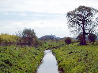
The Hockenhull Platts are three bridges southwest of the village of Tarvin, Cheshire, England. They are also known as the "Packhorse Bridges" or (erroneously) the "Roman Bridges", and are recorded in the National Heritage List for England as designated Grade II listed buildings. The bridges are situated where Platts Lane crosses the River Gowy. An area of 5 hectares west of the Gowy, including the westernmost bridge, forms Hockenhull Platts Nature Reserve, managed by the Cheshire Wildlife Trust.

The Apennine deciduous montane forests are a temperate broadleaf and mixed forests ecoregion in the Apennine Mountains of Italy. The development of these forests is ensured by the high rainfall in the Apennines, combined with a temperate-cool climate. Because of climate change, the presence of silver fir, although still widespread, has been dramatically reduced in favour of beech.

Totteridge Common is a 3.7 hectare Site of Borough Importance for Nature Conservation, Grade II, in Totteridge in the London Borough of Barnet. The nature reserve is the southern verge of the road Totteridge Common, between Totteridge Park and Oak Lodge. It is registered common land owned by the Totteridge Manor Association and comprised the lands of the former Manor of Totteridge which were transferred to the association in 1954.

Salmonsbury Meadows is an 18-hectare (44-acre) biological and geological Site of Special Scientific Interest in Gloucestershire, notified in 1985. The site is listed in the 'Cotswold District' Local Plan 2001-2011 as a Key Wildlife Site (KWS).

Magor Marsh is a 36-hectare (90-acre) wetland reserve, located on the Welsh side of the Severn Estuary. It is managed by the Gwent Wildlife Trust. It has a great variety of habitats, including damp hay meadows, sedge fen, reed bed, scrub and wet woodland. There are also numerous reens and a large pond.

Kobuleti Strict Nature Reserve is a protected area in Kobuleti Municipality, Adjara region of Georgia along the Black Sea coast in the northern part of the resort town Kobuleti. Kobuleti Protected Areas were established in 1998 to preserve unique wetland ecosystems recognized by the Ramsar Convention. Because of these wetland ecosystems, ancient forests, and the high biodiversity found within the reserve, it was inscribed on the UNESCO World Heritage List as part of the Colchic Rainforests and Wetlands in 2021.

Ādaži was established in 2004 as a protected landscape in Ādaži and Saulkrasti municipalities of Latvia. Pierīga, Gauja is on the right bank of the lower reaches Ādaži military poligone and its adjacent territories. The area was created to preserve Latvia's rare habitats created during military training - dry heaths and open inland dunes with sand dune meadows, bluish meadow meadows and mesotrophic lakes, as well as a significant number of specially protected plant and animal species. The area also includes the Lieluika and Mazuika lakes nature reserve. Lake Mazuika is recognized as a benchmark for a clear water lake in the Baltic region. Natura 2000 territory.

