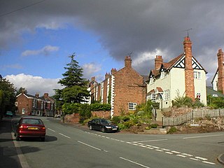
Farndon is a village and civil parish in the unitary authority of Cheshire West and Chester and the ceremonial county of Cheshire, England. It is on the banks of the River Dee, south of Chester, which here forms the England–Wales border. The Welsh village of Holt lies just over the River Dee from Farndon.

Elton is a village and civil parish in Cheshire West and Chester, Cheshire, England, 13 km (8.1 mi) northeast of Chester, between Helsby and Ellesmere Port, near the River Mersey. Its proximity to the Mersey and the Manchester Ship Canal have contributed to its industrial character. The village is on the north-western edge of the Cheshire Plain, 2.5 km (1.6 mi) from Stanlow Refinery.
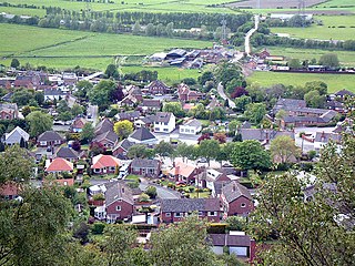
Helsby is a village, civil parish and electoral ward in the unitary authority of Cheshire West and Chester and the ceremonial county of Cheshire, England. Overlooking the Mersey estuary, it is approximately 9 miles (14 km) north east of Chester and 2.5 miles (4 km) south west of Frodsham.

Dunham-on-the-Hill is a village and former civil parish, now in the parish of Dunham-on-the-Hill and Hapsford, in the unitary authority of Cheshire West and Chester, and the ceremonial county of Cheshire, England. It is on the A56 road, approximately 2.3 miles (3.7 km) from Helsby and 6 miles (9.7 km) from Chester. The village is 120 feet (37 m) above sea level, south west of Helsby Hill.
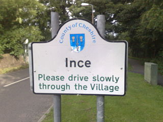
Ince is a village and civil parish in the unitary authority of Cheshire West and Chester and the ceremonial county of Cheshire, England. It is situated immediately to the east of the Stanlow Oil Refinery. It shares Ince & Elton railway station with the village of Elton, which it runs into.

Acton is a small village and former civil parish, now in the parish of Burland and Acton, lying immediately west of the town of Nantwich, in the unitary authority area of Cheshire East and the ceremonial county of Cheshire, England. The civil parish covered 762 acres (3.08 km2) and also included the small settlement of Dorfold and part of Burford, with an estimated population of 340 in 2006. It is administered jointly with the adjacent civil parishes of Henhull and Edleston. Historically, Acton refers to a township and also to an ancient parish in the Nantwich Hundred covering a wide area to the west of Nantwich. The area is agricultural, with dairy farming the main industry. Around a third of the area falls within the Dorfold Estate. Historically, agriculture was the major employer, but it has now been overtaken by the service industries, with many residents commuting significant distances outside the parish to work.

Chester was a rural district of Cheshire, England, from 1894 to 1974. It was located near the city and county borough of Chester but did not include it. The district saw various boundary changes throughout its life. It included the small civil parish of Chester Castle, an exclave of the rural district within the boundaries of the county borough of Chester.

Bickley is a village in the parish of No Man's Heath and District in Cheshire West and Chester and Cheshire, England. According to the 2001 Census it had a population of 498, that reduced to 481 at the 2011 census. The parish included the villages of Bickley Town and Bickley Moss. Bickley was a township in the parish of Malpas. In 1866 Bickley became a civil parish and on 1 April 2015 it was abolished to form "No Mans Heath and District".

The Hooton–Helsby line is a railway line in the north-west of England that runs from Hooton on the Chester–Birkenhead line to the village and junction station at Helsby where it joins the Chester–Warrington line.

Cheshire West and Chester is a unitary authority area with borough status in Cheshire, England. It was established on 1 April 2009 as part of the 2009 local government changes, by virtue of an order under the Local Government and Public Involvement in Health Act 2007. It superseded the boroughs of Ellesmere Port and Neston, Vale Royal and the City of Chester; its council assumed the functions and responsibilities of the former Cheshire County Council within its area. The remainder of ceremonial Cheshire is composed of Cheshire East, Halton and Warrington. Cheshire West and Chester has three key urban areas: Chester, Ellesmere Port and Northwich/Winsford.

Swettenham is a village and civil parish in the unitary authority of Cheshire East and the ceremonial county of Cheshire, England. According to the 2001 Official UK Census, the population of the entire civil parish was 248, increasing to 291 at the 2011 Census. The civil parish includes the hamlet of Kermincham.

St James' Church is in the village of Ince, Cheshire, England. The church is recorded in the National Heritage List for England as a designated Grade II* listed building. It is an active Anglican parish church in the diocese of Chester, the archdeaconry of Chester and the deanery of Frodsham. Its benefice is united with that of St Mary, Thornton-le-Moors.

St Mary's Church is a redundant Anglican church in the small village of Thornton-le-Moors, Cheshire, England. The church is recorded in the National Heritage List for England as a designated Grade I listed building, and it is in the care of the Churches Conservation Trust.

Hapsford is a village and former civil parish, now in the parish of Dunham-on-the-Hill and Hapsford, in the unitary authority area of Cheshire West and Chester and the ceremonial county of Cheshire, England. It is located on the A5117 road, with Helsby to the east and the village of Elton, near Ellesmere Port, to the north west. Junction 14 of the M56 motorway and Chester services motorway service station are sited nearby.
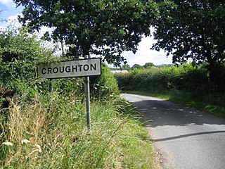
Croughton is a hamlet and civil parish on the outskirts and 3.5 miles (5.7 km) north of the city of Chester, and part of the unitary authority of Cheshire West and Chester and the ceremonial county of Cheshire. The Shropshire Union Canal runs through Croughton.

Clutton is a village and civil parish in the unitary authority of Cheshire West and Chester and the ceremonial county of Cheshire, England. It lies nine miles from Wrexham and 11 miles from Chester. It had a population of 371 according to the 2011 census.

Wimbolds Trafford is a hamlet and former civil parish, now in the parish of Mickle Trafford and District, in the unitary authority area of Cheshire West and Chester and the ceremonial county of Cheshire, England. The hamlet lies on the B5132 road, approximately 5 miles (8 km) to the north east of Chester and north of the village of Mickle Trafford.
Elton is a civil parish in Cheshire West and Chester, England. It contains six buildings that are recorded in the National Heritage List for England as designated listed buildings, all of which are at Grade II. This grade is the lowest of the three gradings given to listed buildings and is applied to "buildings of national importance and special interest".
Thornton-le-Moors is a civil parish in Cheshire West and Chester, England. It contains nine buildings recorded in the National Heritage List for England as designated listed buildings. Of these, one is listed at Grade I, the highest of the three grades, and the others are at Grade II, the lowest grade. Apart from the village of Thornton-le-Moors, the parish is rural, other than the area north of the A5117 road, which is occupied by an oil refinery. The listed buildings consist of the village church and associated structures, houses, farmhouses, and farm buildings.

